[Skip to Content]
Earth From Space
Earth from Space logo  9 Matches Search ResultsEarth from Space logo

Image: gray corner Image: gray corner
View Image Information
Image: Geographic Location
Image: gray corner Image: gray corner

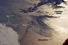
Photo #: ISS023-E-32397 Technical Info
All Available Images Lo-Resolution 0k
Features: OIL SPILL, CHANDELEUR ISLANDS, COAST, DELTA, SUNGLINT, MISSISSIPPI RIVER DELTA, RIVER, WAVE, GULF
Geographic Region: USA-LOUISIANA


Image: gray corner Image: gray corner
View Image Information
Image: Geographic Location
Image: gray corner Image: gray corner

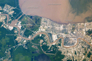
Photo #: ISS027-E-32535 Technical Info
All Available Images Lo-Resolution 0k
Features: LAKE PONTCHARTRAIN, RIVER, MISSISSIPPI RIVER, NEW ORLEANS, SEDIMENT, LAKE, PLUME, FLOODING
Geographic Region: USA-LOUISIANA


Image: gray corner Image: gray corner
View Image Information
Image: Geographic Location
Image: gray corner Image: gray corner

Photo #: ISS059-E-36323 Technical Info
All Available Images Lo-Resolution 0k
Features: LAKE PONTCHARTRAIN, NEW ORLEANS, MISSISSIPPI RIVER, LOUISIANA, BATON ROUGE, RED RIVER, GULF OF MEXICO
Geographic Region: USA-MISSISSIPPI


Image: gray corner Image: gray corner
View Image Information
Image: Geographic Location
Image: gray corner Image: gray corner

Photo #: ISS060-E-556 Technical Info
All Available Images Lo-Resolution 0k
Features: SAINT LOUIS, MISSISSIPPI RIVER
Geographic Region: USA-ILLINOIS


Image: gray corner Image: gray corner
View Image Information
Image: Geographic Location
Image: gray corner Image: gray corner

Photo #: ISS062-E-121160 Technical Info
All Available Images Lo-Resolution 0k
Features: ISLANDS, RIVER, OCEAN, OXBOW LAKE, GREENVILLE, LAKE, AGRICULTURE, SUNGLINT, OLD RIVER, CHANNEL, LAKE FERGUSON, FLOODING, SEDIMENT, MISSISSIPPI RIVER, BASIN, LAKE CHICOT
Geographic Region: USA-MISSISSIPPI


Image: gray corner Image: gray corner
View Image Information
Image: Geographic Location
Image: gray corner Image: gray corner

Photo #: STS036-75-71 Technical Info
All Available Images Lo-Resolution 0k
Features: MISSISSIPPI RIVER, RESERVOIR, AGRICULTURE, PLAIN, RIVER, HILL, URBAN AREA, FOREST
Geographic Region: USA-ILLINOIS


Image: gray corner Image: gray corner
View Image Information
Image: Geographic Location
Image: gray corner Image: gray corner

Photo #: STS066-158-95 Technical Info
All Available Images Lo-Resolution 0k
Features: RIVER, MISSISSIPPI RIVER, FLOOD PLAIN, AGRICULTURE
Geographic Region: USA-MISSISSIPPI


Image: gray corner Image: gray corner
View Image Information
Image: Geographic Location
Image: gray corner Image: gray corner

Photo #: STS091-707-27 Technical Info
All Available Images Lo-Resolution 0k
Features: FLOOD PLAIN, AGRICULTURE, AGR., RIVER, MISSISSIPPI RIVER
Geographic Region: USA-ARKANSAS


Image: gray corner Image: gray corner
View Image Information
Image: Geographic Location
Image: gray corner Image: gray corner

Photo #: STS61A-42-51 Technical Info
All Available Images Lo-Resolution 0k
Features: CHANNEL, RIVER, MISSISSIPPI RIVER DELTA, DELTA, SWAMP, COAST, SEDIMENT, ISLAND
Geographic Region: USA-LOUISIANA


NASA
Home Page
JSC
Home Page
JSC Digital
Image Collection
Earth Science &
Remote Sensing
NASA meatball logo
This service is provided by the International Space Station program and the JSC Earth Science & Remote Sensing Unit, ARES Division, Exploration Integration Science Directorate.
ESRS logo