Geographic Region: USA-COLORADO
Feature: DENVER
|
Geographic Region: USA-COLORADO Feature: DENVER |
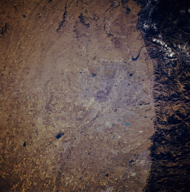 |
| STS61A-048-0094 Denver, Colorado, U.S.A. November 1985 The dark, forested Front Range of the Rocky Mountains provides a dramatic and abrupt landform change from the western edge of the Great Plains. Visible at this scale is little of the infrastructure of Denver--some street grid patterns; dark, irregularly shaped lakes and reservoirs scattered across the urban area; and part of the north-flowing South Platte River. The picture was taken prior to the construction of the Denver International Airport northeast of the city. |
| Images: | Images: | NO IMAGES YET | |||
| Mission: | STS61A |
||||
| Roll - Frame: | 48 - 94 |
||||
| Geographical Name: | USA-COLORADO |
||||
| Features: | DENVER |
||||
| Center Lat x Lon: | 39.5N x 105W |
||||
| Film Exposure: | N | N=Normal exposure, U=Under exposed, O=Over exposed, F=out of Focus |
|||
| Percentage of Cloud Cover-CLDP: | 0 |
||||
| Camera:: | HB |
||||
| Camera Tilt: | 38 | LO=Low Oblique, HO=High Oblique, NV=Near Vertical |
|||
| Camera Focal Length: | 250 |
||||
| Nadir to Photo Center Direction: | SE | The direction from the nadir to the center point, N=North, S=South, E=East, W=West |
|||
| Stereo?: | N | Y=Yes there is an adjacent picture of the same area, N=No there isn't |
|||
| Orbit Number: | 65 |
||||
| Date: | 19851103 | YYYYMMDD |
|||
| Time: | 181537 | GMT HHMMSS |
|||
| Nadir Lat: | 41.3N |
Latitude of suborbital point of spacecraft | |||
| Nadir Lon: | 106.5W |
Longitude of suborbital point of spacecraft | |||
| Sun Azimuth: | 170 | Clockwise angle in degrees from north to the sun measured at the nadir point |
|||
| Space Craft Altitude: | 179 | nautical miles |
|||
| Sun Elevation: | 33 | Angle in degrees between the horizon and the sun, measured at the nadir point |
|||
| Land Views: | PLAIN, MOUNTAIN |
||||
| Water Views: | RIVER, RESERVOIR |
||||
| Atmosphere Views: | |
||||
| Man Made Views: | AIRPORT, AGRICULTURE |
||||
| City Views: | |
||||
Photo is not associated with any sequences | |||||
| NASA Home Page |
JSC Home Page |
JSC Digital Image Collection |
Earth Science & Remote Sensing |
|
This service is provided by the International Space Station program and the JSC Earth Science & Remote Sensing Unit, ARES Division, Exploration Integration Science Directorate.

|