Geographic Region: USA-WASHINGTON
Feature: COLUMBIA RIVER
|
Geographic Region: USA-WASHINGTON Feature: COLUMBIA RIVER |
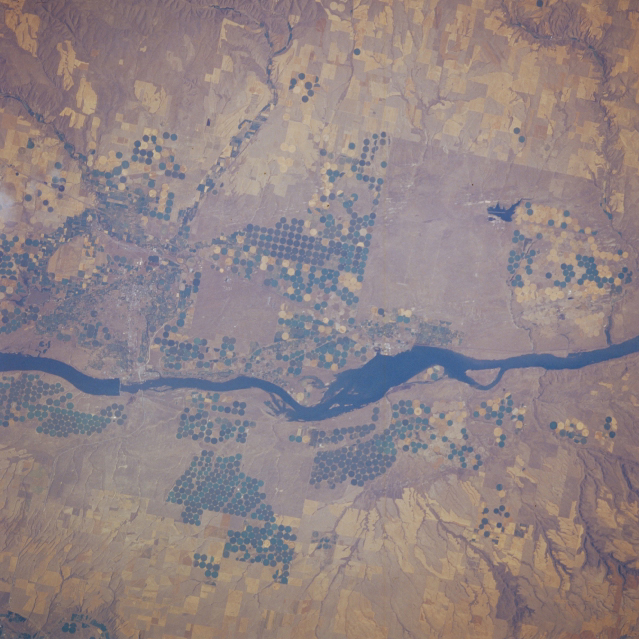 |
| STS51F-035-0011 Columbia River, Oregon and Washington, U.S.A. August 1985 This low-oblique, east-northeast-looking photograph shows the Columbia River downstream from McNary Dam. Visible are numerous agricultural field patterns, including pivot-irrigation fields on both sides of the river. The small city of Hermiston, Oregon, is barely discernible south of McNary Dam. |
| Images: | Images: | NO IMAGES YET | |||
| Mission: | STS51F |
||||
| Roll - Frame: | 35 - 11 |
||||
| Geographical Name: | USA-WASHINGTON |
||||
| Features: | COLUMBIA RIVER |
||||
| Center Lat x Lon: | 46.0N x 119.5W |
||||
| Film Exposure: | N | N=Normal exposure, U=Under exposed, O=Over exposed, F=out of Focus |
|||
| Percentage of Cloud Cover-CLDP: | 5 |
||||
| Camera:: | HB |
||||
| Camera Tilt: | 18 | LO=Low Oblique, HO=High Oblique, NV=Near Vertical |
|||
| Camera Focal Length: | 250 |
||||
| Nadir to Photo Center Direction: | W | The direction from the nadir to the center point, N=North, S=South, E=East, W=West |
|||
| Stereo?: | N | Y=Yes there is an adjacent picture of the same area, N=No there isn't |
|||
| Orbit Number: | 82 |
||||
| Date: | 19850803 | YYYYMMDD |
|||
| Time: | 233752 | GMT HHMMSS |
|||
| Nadir Lat: | 45.7N |
Latitude of suborbital point of spacecraft | |||
| Nadir Lon: | 118.6W |
Longitude of suborbital point of spacecraft | |||
| Sun Azimuth: | 256 | Clockwise angle in degrees from north to the sun measured at the nadir point |
|||
| Space Craft Altitude: | 176 | nautical miles |
|||
| Sun Elevation: | 37 | Angle in degrees between the horizon and the sun, measured at the nadir point |
|||
| Land Views: | |
||||
| Water Views: | |
||||
| Atmosphere Views: | |
||||
| Man Made Views: | DAM, AGRICULTURE, PIVOT IRRIGATION |
||||
| City Views: | |
||||
Photo is not associated with any sequences | |||||
| NASA Home Page |
JSC Home Page |
JSC Digital Image Collection |
Earth Science & Remote Sensing |
|
This service is provided by the International Space Station program and the JSC Earth Science & Remote Sensing Unit, ARES Division, Exploration Integration Science Directorate.

|