Geographic Region: USA-TENNESSEE
Feature: CHATTANOOGA
|
Geographic Region: USA-TENNESSEE Feature: CHATTANOOGA |
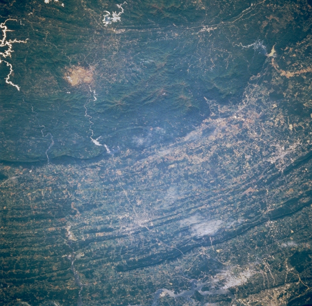 |
| STS51B-053-0020 Cleveland, Tennessee, U.S.A. May 1985 Four highly reflective reservoirs in the upper third of the photograph--large Hiwassee Lake (North Carolina), Nottley Lake (Georgia), Blue Ridge Lake (Georgia) and Lake Ocoee (Tennessee)--are partially visible in the forested Blue Ridge Mountains, part of the much larger Appalachian Mountains. Surrounded by these reservoirs is a circular, deforested area, which is probably the result of environmental degradation. West of the forested mountains is a series of paralleling, concentric arcs of darker, forested ridgelines and narrow valleys. Barely visible are south Chattanooga (bottom right) with Interstate Highway 75 and a railroad that connect Chattanooga with Cleveland, Tennessee, and Dalton, Georgia. |
| Images: | Images: | NO IMAGES YET | |||
| Mission: | STS51B |
||||
| Roll - Frame: | 53 - 20 |
||||
| Geographical Name: | USA-TENNESSEE |
||||
| Features: | CHATTANOOGA |
||||
| Center Lat x Lon: | 35.0N x 84.5W |
||||
| Film Exposure: | N | N=Normal exposure, U=Under exposed, O=Over exposed, F=out of Focus |
|||
| Percentage of Cloud Cover-CLDP: | 5 |
||||
| Camera:: | HB |
||||
| Camera Tilt: | NV | LO=Low Oblique, HO=High Oblique, NV=Near Vertical |
|||
| Camera Focal Length: | 250 |
||||
| Nadir to Photo Center Direction: | The direction from the nadir to the center point, N=North, S=South, E=East, W=West |
||||
| Stereo?: | Y | Y=Yes there is an adjacent picture of the same area, N=No there isn't |
|||
| Orbit Number: | 79 |
||||
| Date: | 1985____ | YYYYMMDD |
|||
| Time: | GMT HHMMSS |
||||
| Nadir Lat: | N |
Latitude of suborbital point of spacecraft | |||
| Nadir Lon: | E |
Longitude of suborbital point of spacecraft | |||
| Sun Azimuth: | Clockwise angle in degrees from north to the sun measured at the nadir point |
||||
| Space Craft Altitude: | nautical miles |
||||
| Sun Elevation: | Angle in degrees between the horizon and the sun, measured at the nadir point |
||||
| Land Views: | MOUNTAIN, VALLEY |
||||
| Water Views: | RESERVOIR |
||||
| Atmosphere Views: | |
||||
| Man Made Views: | |
||||
| City Views: | |
||||
Photo is not associated with any sequences | |||||
| NASA Home Page |
JSC Home Page |
JSC Digital Image Collection |
Earth Science & Remote Sensing |
|
This service is provided by the International Space Station program and the JSC Earth Science & Remote Sensing Unit, ARES Division, Exploration Integration Science Directorate.

|