Geographic Region: TAIWAN
Feature: ENTIRE ISLAND,BASHI STR.
|
Geographic Region: TAIWAN Feature: ENTIRE ISLAND,BASHI STR. |
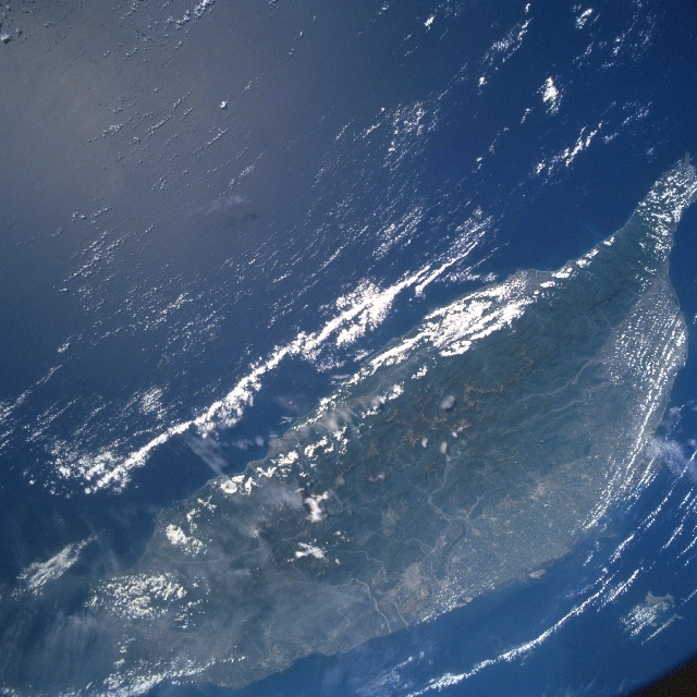 |
| STS090-730-066 Island of Taiwan April 1998 Even though clouds and some haze (northern end of island) obscure parts of Taiwan, the entire north-south extent of the island is visible in this synoptic southeast-looking view. On the eastern half of the island, the Chungyang Mountains with steep slopes and dense forests dark area) dominate the landscape. Many of the higher elevations in this rugged mountainous region exceed 10000 feet (3000 meters) above sea level. The highly industrialized and densely populated lowland corridor is visible along the west coast of Taiwan from the capital city of Taipei (north) to the Kaohsiung area along the southwest coast. Several short-flowing rivers (light colored lines) can be traced through the western slopes of the Chungyang Mountains and across the narrow coastal plains. |
| Images: | Images: | NO IMAGES YET | |||
| Mission: | STS090 |
||||
| Roll - Frame: | 730 - 66 |
||||
| Geographical Name: | TAIWAN |
||||
| Features: | ENTIRE ISLAND,BASHI STR. |
||||
| Center Lat x Lon: | 23.5N x 122.0E |
||||
| Film Exposure: | N | N=Normal exposure, U=Under exposed, O=Over exposed, F=out of Focus |
|||
| Percentage of Cloud Cover-CLDP: | 15 |
||||
| Camera:: | HB |
||||
| Camera Tilt: | 8 | LO=Low Oblique, HO=High Oblique, NV=Near Vertical |
|||
| Camera Focal Length: | 40 |
||||
| Nadir to Photo Center Direction: | E | The direction from the nadir to the center point, N=North, S=South, E=East, W=West |
|||
| Stereo?: | N | Y=Yes there is an adjacent picture of the same area, N=No there isn't |
|||
| Orbit Number: | 86 |
||||
| Date: | 19980423 | YYYYMMDD |
|||
| Time: | 013225 | GMT HHMMSS |
|||
| Nadir Lat: | 23.4N |
Latitude of suborbital point of spacecraft | |||
| Nadir Lon: | 121.7E |
Longitude of suborbital point of spacecraft | |||
| Sun Azimuth: | 102 | Clockwise angle in degrees from north to the sun measured at the nadir point |
|||
| Space Craft Altitude: | 134 | nautical miles |
|||
| Sun Elevation: | 55 | Angle in degrees between the horizon and the sun, measured at the nadir point |
|||
| Land Views: | MOUNTAIN, FOREST, PLAIN |
||||
| Water Views: | RIVER |
||||
| Atmosphere Views: | |
||||
| Man Made Views: | |
||||
| City Views: | |
||||
Photo is not associated with any sequences | |||||
| NASA Home Page |
JSC Home Page |
JSC Digital Image Collection |
Earth Science & Remote Sensing |
|
This service is provided by the International Space Station program and the JSC Earth Science & Remote Sensing Unit, ARES Division, Exploration Integration Science Directorate.

|