Geographic Region: TURKMENISTAN
Feature: PAN-TSENTRALNYYE DES,SEA
|
Geographic Region: TURKMENISTAN Feature: PAN-TSENTRALNYYE DES,SEA |
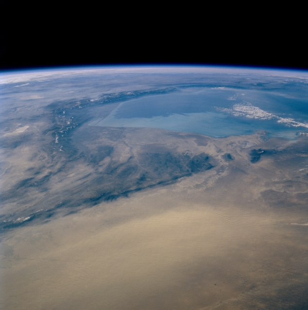 |
| STS074-735-007 Kopet Mountains, Turkmenistan November 1995 Most of arid, western Turkmenistan is visible in this southwest-looking panoramic view that includes the southern end of the Caspian Sea (large light blue feature near horizon). A sizeable dust storm (lighter-colored, uniform-looking) is in progress, blowing dust towards the southwest in the bottom third of the image. The darker features are mountain ranges. The linear, northwest-southeast aligned Kopet Mountains extend diagonally across the scene along a fault zone that is located along the northeast-facing base of the mountains. Several snow-capped peaks and ridgelines of the mountains in northern Iran, including the Elburz Mountains (along the southern edge of the Caspian Sea) are discernible towards the left horizon. |
| Images: | Images: | NO IMAGES YET | |||
| Mission: | STS074 |
||||
| Roll - Frame: | 735 - 7 |
||||
| Geographical Name: | TURKMENISTAN |
||||
| Features: | PAN-TSENTRALNYYE DES,SEA |
||||
| Center Lat x Lon: | 38.5N x 55.0E |
||||
| Film Exposure: | N | N=Normal exposure, U=Under exposed, O=Over exposed, F=out of Focus |
|||
| Percentage of Cloud Cover-CLDP: | 5 |
||||
| Camera:: | HB |
||||
| Camera Tilt: | HO | LO=Low Oblique, HO=High Oblique, NV=Near Vertical |
|||
| Camera Focal Length: | 100 |
||||
| Nadir to Photo Center Direction: | W | The direction from the nadir to the center point, N=North, S=South, E=East, W=West |
|||
| Stereo?: | N | Y=Yes there is an adjacent picture of the same area, N=No there isn't |
|||
| Orbit Number: | 15 |
||||
| Date: | 19951113 | YYYYMMDD |
|||
| Time: | 100829 | GMT HHMMSS |
|||
| Nadir Lat: | 40.7N |
Latitude of suborbital point of spacecraft | |||
| Nadir Lon: | 63.7E |
Longitude of suborbital point of spacecraft | |||
| Sun Azimuth: | 221 | Clockwise angle in degrees from north to the sun measured at the nadir point |
|||
| Space Craft Altitude: | 175 | nautical miles |
|||
| Sun Elevation: | 21 | Angle in degrees between the horizon and the sun, measured at the nadir point |
|||
| Land Views: | MOUNTAIN |
||||
| Water Views: | SEA |
||||
| Atmosphere Views: | DUST |
||||
| Man Made Views: | |
||||
| City Views: | |
||||
Photo is not associated with any sequences | |||||
| NASA Home Page |
JSC Home Page |
JSC Digital Image Collection |
Earth Science & Remote Sensing |
|
This service is provided by the International Space Station program and the JSC Earth Science & Remote Sensing Unit, ARES Division, Exploration Integration Science Directorate.

|