Geographic Region: USA-COLORADO
Feature: AGR., MTS., RIO GRANDE
|
Geographic Region: USA-COLORADO Feature: AGR., MTS., RIO GRANDE |
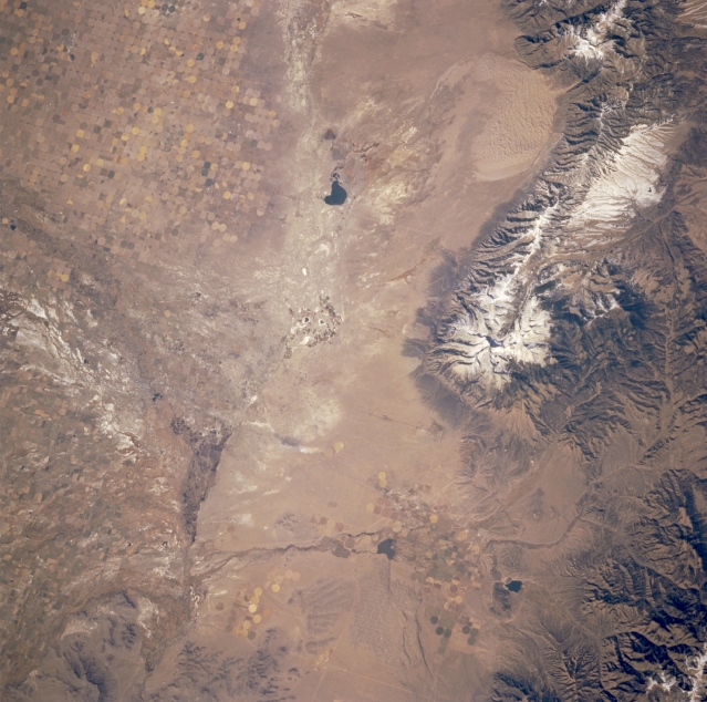 |
| STS073-740-025 San Luis Valley, Colorado, U.S.A. October 1995 Part of the San Luis Valley of south-central Colorado is featured in this north-looking, low-oblique photograph. Visible in the valley are circular patterns produced by center-pivot irrigation; snowcapped Blanca Peak [14 345 feet (4372 meters) above sea level], north of which is Great Sand Dunes National Monument; and part of the Sangre de Cristo Mountains. Apparent are intermittently flowing San Luis Creek that travels south across the valley; dark San Luis Lake; and intermittently flowing water channels of the Rio Grande that merge with San Luis Creek near Alamosa (not discernible in this photograph). West of the Rio Grande is a light saline surface caused by the repetitive deposition and evaporation process in this desertlike landscape. |
| Images: | Images: | NO IMAGES YET | |||
| Mission: | STS073 |
||||
| Roll - Frame: | 740 - 25 |
||||
| Geographical Name: | USA-COLORADO |
||||
| Features: | AGR., MTS., RIO GRANDE |
||||
| Center Lat x Lon: | 37.5N x 105.5W |
||||
| Film Exposure: | N | N=Normal exposure, U=Under exposed, O=Over exposed, F=out of Focus |
|||
| Percentage of Cloud Cover-CLDP: | 0 |
||||
| Camera:: | HB |
||||
| Camera Tilt: | 29 | LO=Low Oblique, HO=High Oblique, NV=Near Vertical |
|||
| Camera Focal Length: | 250 |
||||
| Nadir to Photo Center Direction: | W | The direction from the nadir to the center point, N=North, S=South, E=East, W=West |
|||
| Stereo?: | Y | Y=Yes there is an adjacent picture of the same area, N=No there isn't |
|||
| Orbit Number: | 52 |
||||
| Date: | 19951023 | YYYYMMDD |
|||
| Time: | 183244 | GMT HHMMSS |
|||
| Nadir Lat: | 37.1N |
Latitude of suborbital point of spacecraft | |||
| Nadir Lon: | 104.2W |
Longitude of suborbital point of spacecraft | |||
| Sun Azimuth: | 177 | Clockwise angle in degrees from north to the sun measured at the nadir point |
|||
| Space Craft Altitude: | 146 | nautical miles |
|||
| Sun Elevation: | 42 | Angle in degrees between the horizon and the sun, measured at the nadir point |
|||
| Land Views: | VALLEY, DUNE, MOUNTAIN |
||||
| Water Views: | RIVER |
||||
| Atmosphere Views: | |
||||
| Man Made Views: | PIVOT IRRIGATION |
||||
| City Views: | |
||||
Photo is not associated with any sequences | |||||
| NASA Home Page |
JSC Home Page |
JSC Digital Image Collection |
Earth Science & Remote Sensing |
|
This service is provided by the International Space Station program and the JSC Earth Science & Remote Sensing Unit, ARES Division, Exploration Integration Science Directorate.

|