Geographic Region: USA-FLORIDA
Feature: FORT MYERS, HARBOR, IS.
|
Geographic Region: USA-FLORIDA Feature: FORT MYERS, HARBOR, IS. |
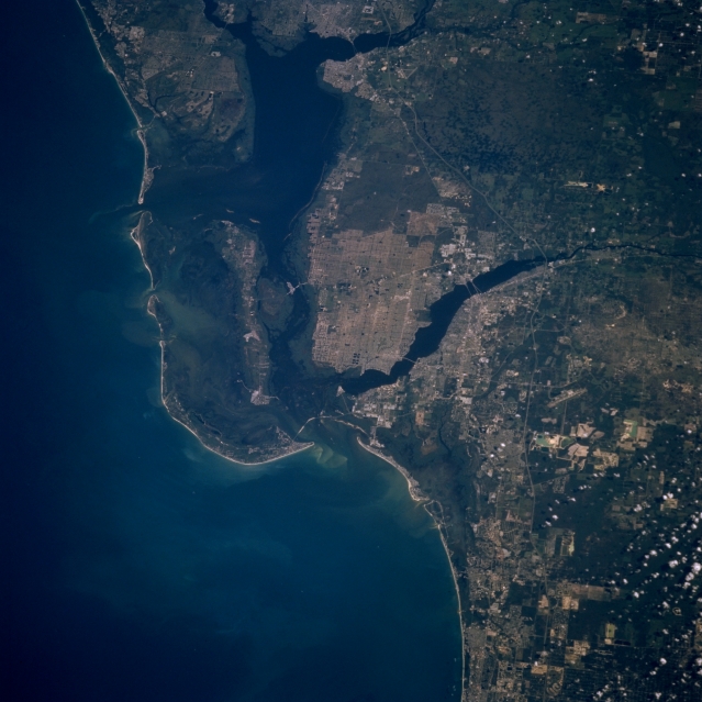 |
| STS070-712-063 Fort Myers, Florida, U.S.A. July 1995 This photograph covers essentially the same area as STS069-718-0053. Readily identifiable from north to south are the mouth of the Peace River at Port Charlotte; Charlotte Harbor; Sanibel and Pine Islands; the expanding cities of North Fort Myers, Cape Coral, and Fort Myers (south of the Caloosahatchee River); and urban and commercial developments south of Fort Myers. Interstate Highway 75 and segments of U.S. Highway 41 are discernible. |
| Images: | Images: | NO IMAGES YET | |||
| Mission: | STS070 |
||||
| Roll - Frame: | 712 - 63 |
||||
| Geographical Name: | USA-FLORIDA |
||||
| Features: | FORT MYERS, HARBOR, IS. |
||||
| Center Lat x Lon: | 26.5N x 82W |
||||
| Film Exposure: | N | N=Normal exposure, U=Under exposed, O=Over exposed, F=out of Focus |
|||
| Percentage of Cloud Cover-CLDP: | 0 |
||||
| Camera:: | HB |
||||
| Camera Tilt: | 32 | LO=Low Oblique, HO=High Oblique, NV=Near Vertical |
|||
| Camera Focal Length: | 250 |
||||
| Nadir to Photo Center Direction: | N | The direction from the nadir to the center point, N=North, S=South, E=East, W=West |
|||
| Stereo?: | N | Y=Yes there is an adjacent picture of the same area, N=No there isn't |
|||
| Orbit Number: | 49 |
||||
| Date: | 19950716 | YYYYMMDD |
|||
| Time: | 141513 | GMT HHMMSS |
|||
| Nadir Lat: | 24.9N |
Latitude of suborbital point of spacecraft | |||
| Nadir Lon: | 81.6W |
Longitude of suborbital point of spacecraft | |||
| Sun Azimuth: | 84 | Clockwise angle in degrees from north to the sun measured at the nadir point |
|||
| Space Craft Altitude: | 155 | nautical miles |
|||
| Sun Elevation: | 45 | Angle in degrees between the horizon and the sun, measured at the nadir point |
|||
| Land Views: | COAST, PLAIN, ISLAND |
||||
| Water Views: | GULF, RIVER, BAY, SWAMP |
||||
| Atmosphere Views: | |
||||
| Man Made Views: | URBAN AREA, HIGHWAY |
||||
| City Views: | |
||||
Photo is not associated with any sequences | |||||
| NASA Home Page |
JSC Home Page |
JSC Digital Image Collection |
Earth Science & Remote Sensing |
|
This service is provided by the International Space Station program and the JSC Earth Science & Remote Sensing Unit, ARES Division, Exploration Integration Science Directorate.

|