Geographic Region: USA-OREGON
Feature: MTS.,LAKES,RESERVOIRS
|
Geographic Region: USA-OREGON Feature: MTS.,LAKES,RESERVOIRS |
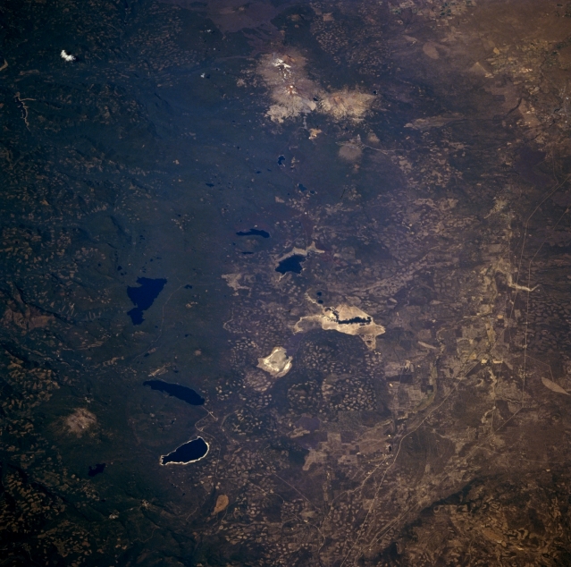 |
| STS068-262-033 Central Oregon Cascades and Three Sisters Peaks, Oregon, U.S.A. October 1994 Visible in this low-oblique, north-looking photograph are the snowcapped peaks of the Three Sisters Volcanoes--North Sister, the oldest of the three, a stratovolcano 5 miles (8 kilometers) wide; Center Sister; and South Sister, the youngest and highest at 10 358 feet (3158 meters). The last major eruption of South Sister occurred nearly 1900 years ago. Mount Bachelor, a famous skiing attraction south of South Sister, is a monogentic volcano 9060 feet (2764 meters) high. Numerous lakes are apparent north to south--Lake Cultus, Crane Prairie Lake, Waldo Lake, Wickiup Reservoir, Davis Lake, Odell Lake, and Crescent Lake. West of Odell Lake and Crescent Lake is Diamond Peak, a shield volcano probably less than a 100 000 years old and the dominant landform in this region. Heavily forested Willamette National Forest and the clear-cutting patterns of lumber companies east of the lakes in the Deschutes National Forest are discernible. |
| Images: | Images: | NO IMAGES YET | |||
| Mission: | STS068 |
||||
| Roll - Frame: | 262 - 33 |
||||
| Geographical Name: | USA-OREGON |
||||
| Features: | MTS.,LAKES,RESERVOIRS |
||||
| Center Lat x Lon: | 43.5N x 121.5W |
||||
| Film Exposure: | N | N=Normal exposure, U=Under exposed, O=Over exposed, F=out of Focus |
|||
| Percentage of Cloud Cover-CLDP: | 0 |
||||
| Camera:: | HB |
||||
| Camera Tilt: | 46 | LO=Low Oblique, HO=High Oblique, NV=Near Vertical |
|||
| Camera Focal Length: | 250 |
||||
| Nadir to Photo Center Direction: | N | The direction from the nadir to the center point, N=North, S=South, E=East, W=West |
|||
| Stereo?: | N | Y=Yes there is an adjacent picture of the same area, N=No there isn't |
|||
| Orbit Number: | 40 |
||||
| Date: | 19941002 | YYYYMMDD |
|||
| Time: | 212910 | GMT HHMMSS |
|||
| Nadir Lat: | 41.6N |
Latitude of suborbital point of spacecraft | |||
| Nadir Lon: | 122.1W |
Longitude of suborbital point of spacecraft | |||
| Sun Azimuth: | 211 | Clockwise angle in degrees from north to the sun measured at the nadir point |
|||
| Space Craft Altitude: | 117 | nautical miles |
|||
| Sun Elevation: | 40 | Angle in degrees between the horizon and the sun, measured at the nadir point |
|||
| Land Views: | RANGE, VOLCANO, FOREST |
||||
| Water Views: | LAKE |
||||
| Atmosphere Views: | |
||||
| Man Made Views: | |
||||
| City Views: | |
||||
Photo is not associated with any sequences | |||||
| NASA Home Page |
JSC Home Page |
JSC Digital Image Collection |
Earth Science & Remote Sensing |
|
This service is provided by the International Space Station program and the JSC Earth Science & Remote Sensing Unit, ARES Division, Exploration Integration Science Directorate.

|