Geographic Region: USA-OKLAHOMA
Feature: CIMARRON R, CANTON LAKE
|
Geographic Region: USA-OKLAHOMA Feature: CIMARRON R, CANTON LAKE |
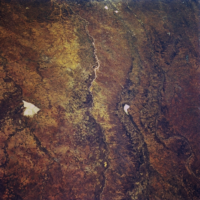 |
| STS068-257-043 Great Salt Plains Lake, Cimarron River, and Canadian River, Oklahoma, U.S.A. October 1994 This southeast-looking, low-oblique, panoramic photograph of west-central Oklahoma shows three river systems that move generally west to east through the state--the Cimarron River; to its south the North Canadian River, which flows through Canton Lake (right of center) eastward into Oklahoma City; and farthest south, the South Canadian River, which flows generally southeastward. Situated on the Salt Fork of the Arkansas River, bright, white Great Salt Plains Lake [10 miles (16 kilometers) long], sometimes dry in the late summer and fall, is used for flood control and conservation. |
| Images: | Images: | NO IMAGES YET | |||
| Mission: | STS068 |
||||
| Roll - Frame: | 257 - 43 |
||||
| Geographical Name: | USA-OKLAHOMA |
||||
| Features: | CIMARRON R, CANTON LAKE |
||||
| Center Lat x Lon: | 36.5N x 98.5W |
||||
| Film Exposure: | N | N=Normal exposure, U=Under exposed, O=Over exposed, F=out of Focus |
|||
| Percentage of Cloud Cover-CLDP: | 0 |
||||
| Camera:: | HB |
||||
| Camera Tilt: | 35 | LO=Low Oblique, HO=High Oblique, NV=Near Vertical |
|||
| Camera Focal Length: | 100 |
||||
| Nadir to Photo Center Direction: | S | The direction from the nadir to the center point, N=North, S=South, E=East, W=West |
|||
| Stereo?: | Y | Y=Yes there is an adjacent picture of the same area, N=No there isn't |
|||
| Orbit Number: | 167 |
||||
| Date: | 19941010 | YYYYMMDD |
|||
| Time: | 171412 | GMT HHMMSS |
|||
| Nadir Lat: | 37.7N |
Latitude of suborbital point of spacecraft | |||
| Nadir Lon: | 99W |
Longitude of suborbital point of spacecraft | |||
| Sun Azimuth: | 156 | Clockwise angle in degrees from north to the sun measured at the nadir point |
|||
| Space Craft Altitude: | 111 | nautical miles |
|||
| Sun Elevation: | 43 | Angle in degrees between the horizon and the sun, measured at the nadir point |
|||
| Land Views: | PLAIN |
||||
| Water Views: | RIVER, PLAYA |
||||
| Atmosphere Views: | |
||||
| Man Made Views: | AGRICULTURE |
||||
| City Views: | |
||||
Photo is not associated with any sequences | |||||
| NASA Home Page |
JSC Home Page |
JSC Digital Image Collection |
Earth Science & Remote Sensing |
|
This service is provided by the International Space Station program and the JSC Earth Science & Remote Sensing Unit, ARES Division, Exploration Integration Science Directorate.

|