Geographic Region: USA-MICHIGAN
Feature: STRAITS OF MACKINAC, BRIDGE
|
Geographic Region: USA-MICHIGAN Feature: STRAITS OF MACKINAC, BRIDGE |
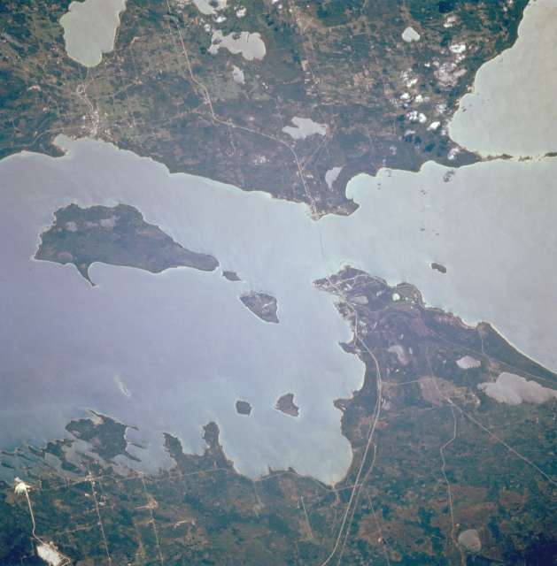 |
| STS068-230-085 Straits of Mackinac, Michigan, U.S.A. October 1994 An important link in the Saint Lawrence Seaway, the Straits of Mackinac, 4 miles (6 kilometers) wide at their narrowest point, are apparent in this south-looking, low-oblique, sunglint-reflected photograph. The Mackinac Straits Bridge (barely discernible), third longest suspension bridge [3800 feet (1159 meters) long] in the world, opened in 1957. Three islands are readily visible--Round Island, the smallest; Mackinac; and Boise Blanc, the largest of the three, south of which lies the city of Cheboygan. Interstate Highway 75 traverses north-south. |
| Images: | Images: | NO IMAGES YET | |||
| Mission: | STS068 |
||||
| Roll - Frame: | 230 - 85 |
||||
| Geographical Name: | USA-MICHIGAN |
||||
| Features: | STRAITS OF MACKINAC, BRIDGE |
||||
| Center Lat x Lon: | 46.0N x 84.5W |
||||
| Film Exposure: | N | N=Normal exposure, U=Under exposed, O=Over exposed, F=out of Focus |
|||
| Percentage of Cloud Cover-CLDP: | 0 |
||||
| Camera:: | HB |
||||
| Camera Tilt: | 27 | LO=Low Oblique, HO=High Oblique, NV=Near Vertical |
|||
| Camera Focal Length: | 250 |
||||
| Nadir to Photo Center Direction: | S | The direction from the nadir to the center point, N=North, S=South, E=East, W=West |
|||
| Stereo?: | N | Y=Yes there is an adjacent picture of the same area, N=No there isn't |
|||
| Orbit Number: | 22 |
||||
| Date: | 19941001 | YYYYMMDD |
|||
| Time: | 184807 | GMT HHMMSS |
|||
| Nadir Lat: | 46.9N |
Latitude of suborbital point of spacecraft | |||
| Nadir Lon: | 84.1W |
Longitude of suborbital point of spacecraft | |||
| Sun Azimuth: | 206 | Clockwise angle in degrees from north to the sun measured at the nadir point |
|||
| Space Craft Altitude: | 118 | nautical miles |
|||
| Sun Elevation: | 37 | Angle in degrees between the horizon and the sun, measured at the nadir point |
|||
| Land Views: | ISLAND, FOREST |
||||
| Water Views: | STRAIT, LAKE |
||||
| Atmosphere Views: | |
||||
| Man Made Views: | MINING |
||||
| City Views: | |
||||
Photo is not associated with any sequences | |||||
| NASA Home Page |
JSC Home Page |
JSC Digital Image Collection |
Earth Science & Remote Sensing |
|
This service is provided by the International Space Station program and the JSC Earth Science & Remote Sensing Unit, ARES Division, Exploration Integration Science Directorate.

|