Geographic Region: USA-TEXAS
Feature: GREENVILLE, L TAWAKONI
|
Geographic Region: USA-TEXAS Feature: GREENVILLE, L TAWAKONI |
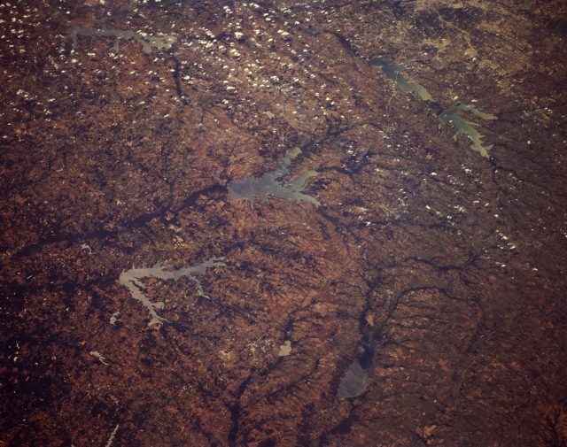 |
| STS068-174-170 Northeast Texas, U.S.A. October 1994 Discernible in this oblique, southwest-looking photograph of northeast Texas are three watersheds--the Trinity River Basin with three large reservoirs [Cedar Creek Reservoir, Lake Ray Hubbard with Interstate Highway 30 crossing its southern end, and Lake Lavon (top right of photograph)]; the Sabine River System with Lake Tawakoni and Lake Folk Reservoir (center of photograph); and the much larger Red River Watershed with dark, east-flowing wooded stream channels, including Lake Cooper, a newly created reservoir, and the South Sulphur River. Visible are part of urban Dallas (upper right corner) and widely scattered cumulus clouds. |
| Images: | Images: | NO IMAGES YET | |||
| Mission: | STS068 |
||||
| Roll - Frame: | 174 - 170 |
||||
| Geographical Name: | USA-TEXAS |
||||
| Features: | GREENVILLE, L TAWAKONI |
||||
| Center Lat x Lon: | 33.0N x 96W |
||||
| Film Exposure: | N | N=Normal exposure, U=Under exposed, O=Over exposed, F=out of Focus |
|||
| Percentage of Cloud Cover-CLDP: | 5 |
||||
| Camera:: | LH |
||||
| Camera Tilt: | 44 | LO=Low Oblique, HO=High Oblique, NV=Near Vertical |
|||
| Camera Focal Length: | 250 |
||||
| Nadir to Photo Center Direction: | W | The direction from the nadir to the center point, N=North, S=South, E=East, W=West |
|||
| Stereo?: | Y | Y=Yes there is an adjacent picture of the same area, N=No there isn't |
|||
| Orbit Number: | 103 |
||||
| Date: | 19941006 | YYYYMMDD |
|||
| Time: | 184502 | GMT HHMMSS |
|||
| Nadir Lat: | 33.7N |
Latitude of suborbital point of spacecraft | |||
| Nadir Lon: | 94.3W |
Longitude of suborbital point of spacecraft | |||
| Sun Azimuth: | 196 | Clockwise angle in degrees from north to the sun measured at the nadir point |
|||
| Space Craft Altitude: | 116 | nautical miles |
|||
| Sun Elevation: | 50 | Angle in degrees between the horizon and the sun, measured at the nadir point |
|||
| Land Views: | PLAIN, RANGE |
||||
| Water Views: | RESERVOIR, RIVER |
||||
| Atmosphere Views: | |
||||
| Man Made Views: | |
||||
| City Views: | |
||||
Photo is not associated with any sequences | |||||
| NASA Home Page |
JSC Home Page |
JSC Digital Image Collection |
Earth Science & Remote Sensing |
|
This service is provided by the International Space Station program and the JSC Earth Science & Remote Sensing Unit, ARES Division, Exploration Integration Science Directorate.

|