Geographic Region: USA-ARIZONA
Feature: AGRICULTURE, COLORADO RIVER
|
Geographic Region: USA-ARIZONA Feature: AGRICULTURE, COLORADO RIVER |
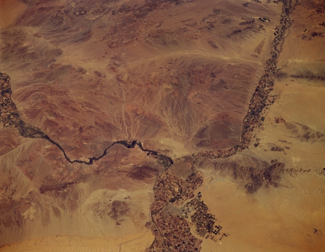 |
| STS068-173-138 Sonoran Desert, Arizona, U.S.A. October 1994 The southwest corner of the sparsely vegetated Sonoran Desert is captured in this low-oblique, northeast-looking photograph. The only diversity in an otherwise arid region is created by the irrigated-field patterns along floodplains of the Colorado River (south-flowing) and the Gila River (southwest-flowing). Several circular center-point irrigation fields are visible south of Yuma (bottom center of the photograph). The Gila Mountains east of Yuma and several other ranges--the Chocolate, Kofa, and Eagle Tail Mountains--can be seen between the Colorado and Gila Rivers. The linear Sand Hills are discernible across the bottom of the photograph. |
| Images: | Images: | NO IMAGES YET | |||
| Mission: | STS068 |
||||
| Roll - Frame: | 173 - 138 |
||||
| Geographical Name: | USA-ARIZONA |
||||
| Features: | AGRICULTURE, COLORADO RIVER |
||||
| Center Lat x Lon: | 33.0N x 114.5W |
||||
| Film Exposure: | N | N=Normal exposure, U=Under exposed, O=Over exposed, F=out of Focus |
|||
| Percentage of Cloud Cover-CLDP: | 0 |
||||
| Camera:: | LH |
||||
| Camera Tilt: | 42 | LO=Low Oblique, HO=High Oblique, NV=Near Vertical |
|||
| Camera Focal Length: | 250 |
||||
| Nadir to Photo Center Direction: | NE | The direction from the nadir to the center point, N=North, S=South, E=East, W=West |
|||
| Stereo?: | Y | Y=Yes there is an adjacent picture of the same area, N=No there isn't |
|||
| Orbit Number: | 120 |
||||
| Date: | 19941007 | YYYYMMDD |
|||
| Time: | 195324 | GMT HHMMSS |
|||
| Nadir Lat: | 32.1N |
Latitude of suborbital point of spacecraft | |||
| Nadir Lon: | 115.9W |
Longitude of suborbital point of spacecraft | |||
| Sun Azimuth: | 189 | Clockwise angle in degrees from north to the sun measured at the nadir point |
|||
| Space Craft Altitude: | 111 | nautical miles |
|||
| Sun Elevation: | 52 | Angle in degrees between the horizon and the sun, measured at the nadir point |
|||
| Land Views: | MOUNTAIN, DESERT |
||||
| Water Views: | RIVER |
||||
| Atmosphere Views: | |
||||
| Man Made Views: | PIVOT IRRIGATION, AGRICULTURE |
||||
| City Views: | |
||||
Photo is not associated with any sequences | |||||
| NASA Home Page |
JSC Home Page |
JSC Digital Image Collection |
Earth Science & Remote Sensing |
|
This service is provided by the International Space Station program and the JSC Earth Science & Remote Sensing Unit, ARES Division, Exploration Integration Science Directorate.

|