Geographic Region: CANADA-S
Feature: SASKATCHEWAN RIVER
|
Geographic Region: CANADA-S Feature: SASKATCHEWAN RIVER |
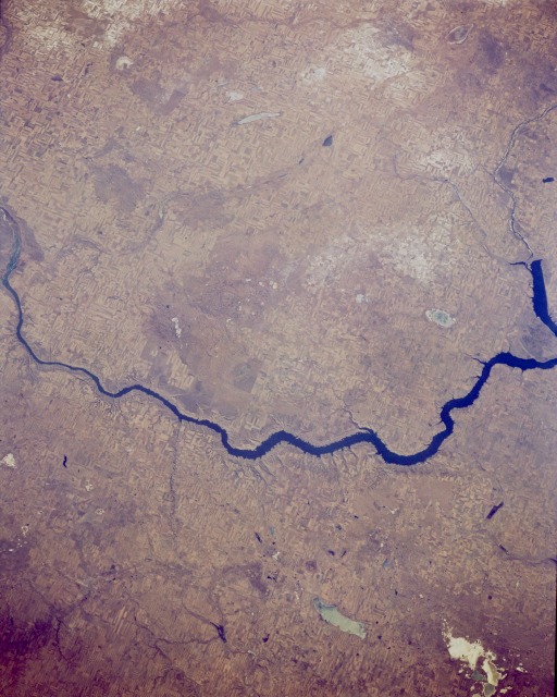 |
| STS066-154-114 South Saskatchewan River, Saskatchewan, Canada November 1994 Lake Diefenbaker, located in southwestern Saskatchewan, is the wide blue sector of the South Saskatchewan River and was created by damming this tributary of the river. One of the dams is located along the center right edge of the picture (abrupt end of the blue lake). Although the agricultural field patterns in this small scale image are not easy to identify, the faint but widespread angular pattern spread across most of the scene represents fence lines aligned diagonally to the edge of the view. The subtle but slightly lighter colored areas north of the South Saskatchewan River suggest a dusting of snow. The grayish feature south of Lake Diefenbaker is Reed Lake (bottom center) and the whitish feature near the lower right corner of the image is Chaplin Lake. Both are dry lakes, indicating the semi-aridity of the Canadian high plains/prairie provinces. A few lakes, such as Luck and Barber, are discernible north of Lake Diefenbaker. |
| Images: | Images: | NO IMAGES YET | |||
| Mission: | STS066 |
||||
| Roll - Frame: | 154 - 114 |
||||
| Geographical Name: | CANADA-S |
||||
| Features: | SASKATCHEWAN RIVER |
||||
| Center Lat x Lon: | 51.0N x 107.5W |
||||
| Film Exposure: | N | N=Normal exposure, U=Under exposed, O=Over exposed, F=out of Focus |
|||
| Percentage of Cloud Cover-CLDP: | 0 |
||||
| Camera:: | LH |
||||
| Camera Tilt: | 27 | LO=Low Oblique, HO=High Oblique, NV=Near Vertical |
|||
| Camera Focal Length: | 250 |
||||
| Nadir to Photo Center Direction: | N | The direction from the nadir to the center point, N=North, S=South, E=East, W=West |
|||
| Stereo?: | N | Y=Yes there is an adjacent picture of the same area, N=No there isn't |
|||
| Orbit Number: | 66 |
||||
| Date: | 19941107 | YYYYMMDD |
|||
| Time: | 191547 | GMT HHMMSS |
|||
| Nadir Lat: | 49.7N |
Latitude of suborbital point of spacecraft | |||
| Nadir Lon: | 107.1W |
Longitude of suborbital point of spacecraft | |||
| Sun Azimuth: | 186 | Clockwise angle in degrees from north to the sun measured at the nadir point |
|||
| Space Craft Altitude: | 161 | nautical miles |
|||
| Sun Elevation: | 24 | Angle in degrees between the horizon and the sun, measured at the nadir point |
|||
| Land Views: | PLAIN |
||||
| Water Views: | RIVER, LAKE |
||||
| Atmosphere Views: | |
||||
| Man Made Views: | AGRICULTURE |
||||
| City Views: | |
||||
Photo is not associated with any sequences | |||||
| NASA Home Page |
JSC Home Page |
JSC Digital Image Collection |
Earth Science & Remote Sensing |
|
This service is provided by the International Space Station program and the JSC Earth Science & Remote Sensing Unit, ARES Division, Exploration Integration Science Directorate.

|