Geographic Region: USA-OKLAHOMA
Feature: AREA W OF TULSA
|
Geographic Region: USA-OKLAHOMA Feature: AREA W OF TULSA |
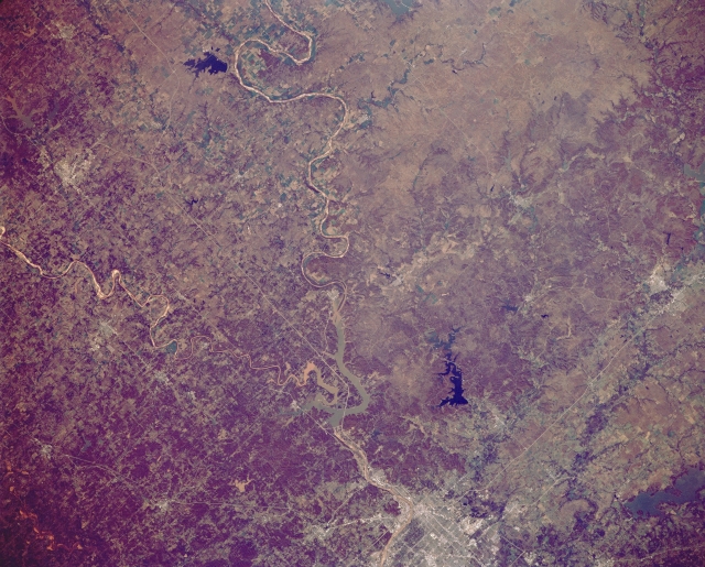 |
| STS066-152-121 Arkansas River and Keystone Lake, Oklahoma, U.S.A. November 1994 The Arkansas River and much of north-central Oklahoma appear in this northwest-looking, low-oblique photograph. Dark blue Skiatook Lake lies north of silty Keystone Lake, which receives the southeast-flowing Arkansas River (upper center) and the east-flowing Cimarron River. Stillwater, just north of the Cimarron River, is a market and processing center for the surrounding farm and livestock area. Bartlesville, 41 miles (66 kilometers) north of Tulsa, is a distribution center for a ranching and rich oil producing area. West of Bartlesville and north of the Arkansas River appears the grass-covered, low, rolling terrain of the southern Flint Hills. |
| Images: | Images: | NO IMAGES YET | |||
| Mission: | STS066 |
||||
| Roll - Frame: | 152 - 121 |
||||
| Geographical Name: | USA-OKLAHOMA |
||||
| Features: | AREA W OF TULSA |
||||
| Center Lat x Lon: | 36.0N x 96.5W |
||||
| Film Exposure: | U | N=Normal exposure, U=Under exposed, O=Over exposed, F=out of Focus |
|||
| Percentage of Cloud Cover-CLDP: | 0 |
||||
| Camera:: | LH |
||||
| Camera Tilt: | 8 | LO=Low Oblique, HO=High Oblique, NV=Near Vertical |
|||
| Camera Focal Length: | 90 |
||||
| Nadir to Photo Center Direction: | S | The direction from the nadir to the center point, N=North, S=South, E=East, W=West |
|||
| Stereo?: | N | Y=Yes there is an adjacent picture of the same area, N=No there isn't |
|||
| Orbit Number: | 49 |
||||
| Date: | 19941106 | YYYYMMDD |
|||
| Time: | 173240 | GMT HHMMSS |
|||
| Nadir Lat: | 36.4N |
Latitude of suborbital point of spacecraft | |||
| Nadir Lon: | 96.5W |
Longitude of suborbital point of spacecraft | |||
| Sun Azimuth: | 169 | Clockwise angle in degrees from north to the sun measured at the nadir point |
|||
| Space Craft Altitude: | 162 | nautical miles |
|||
| Sun Elevation: | 37 | Angle in degrees between the horizon and the sun, measured at the nadir point |
|||
| Land Views: | PLAIN |
||||
| Water Views: | RIVER, LAKE |
||||
| Atmosphere Views: | |
||||
| Man Made Views: | AGRICULTURE, URBAN AREA |
||||
| City Views: | |
||||
Photo is not associated with any sequences | |||||
| NASA Home Page |
JSC Home Page |
JSC Digital Image Collection |
Earth Science & Remote Sensing |
|
This service is provided by the International Space Station program and the JSC Earth Science & Remote Sensing Unit, ARES Division, Exploration Integration Science Directorate.

|