Geographic Region: USA-UTAH
Feature: LAKE POWELL, COLORADO R.
|
Geographic Region: USA-UTAH Feature: LAKE POWELL, COLORADO R. |
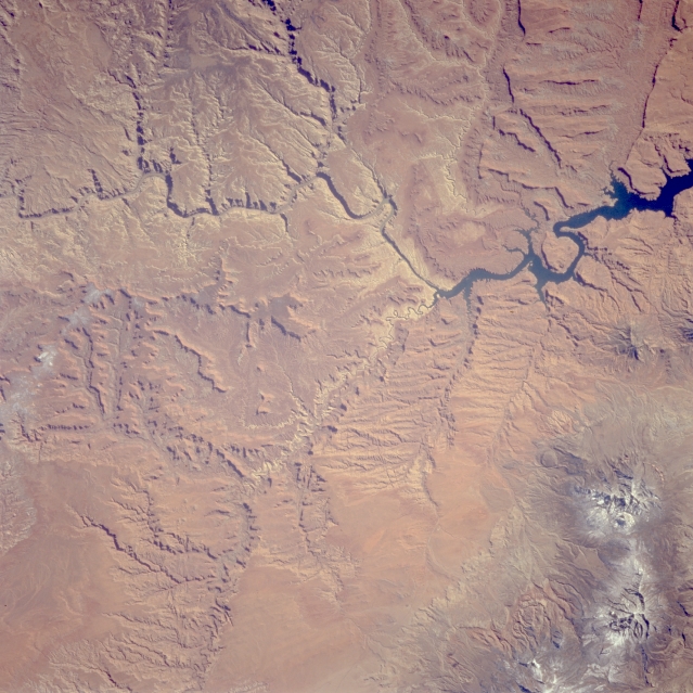 |
| STS066-121-005 Colorado and Dirty Devil Rivers, Utah, U.S.A. November 1994 This southeast-looking, low-oblique photograph features part of the Colorado River winding its way northwestward through numerous canyons in Canyonlands National Park. The northern part of Lake Powell and the forested, snow-covered Henry Mountains to its north are visible. The Dirty Devil River joins Lake Powell (center of the photograph). |
| Images: | Images: | NO IMAGES YET | |||
| Mission: | STS066 |
||||
| Roll - Frame: | 121 - 5 |
||||
| Geographical Name: | USA-UTAH |
||||
| Features: | LAKE POWELL, COLORADO R. |
||||
| Center Lat x Lon: | 38.0N x 110.5W |
||||
| Film Exposure: | N | N=Normal exposure, U=Under exposed, O=Over exposed, F=out of Focus |
|||
| Percentage of Cloud Cover-CLDP: | 0 |
||||
| Camera:: | HB |
||||
| Camera Tilt: | 5 | LO=Low Oblique, HO=High Oblique, NV=Near Vertical |
|||
| Camera Focal Length: | 100 |
||||
| Nadir to Photo Center Direction: | N | The direction from the nadir to the center point, N=North, S=South, E=East, W=West |
|||
| Stereo?: | Y | Y=Yes there is an adjacent picture of the same area, N=No there isn't |
|||
| Orbit Number: | 34 |
||||
| Date: | 19941105 | YYYYMMDD |
|||
| Time: | 185526 | GMT HHMMSS |
|||
| Nadir Lat: | 37.8N |
Latitude of suborbital point of spacecraft | |||
| Nadir Lon: | 110.4W |
Longitude of suborbital point of spacecraft | |||
| Sun Azimuth: | 177 | Clockwise angle in degrees from north to the sun measured at the nadir point |
|||
| Space Craft Altitude: | 163 | nautical miles |
|||
| Sun Elevation: | 37 | Angle in degrees between the horizon and the sun, measured at the nadir point |
|||
| Land Views: | PLATEAU, MOUNTAIN |
||||
| Water Views: | RIVER, LAKE |
||||
| Atmosphere Views: | |
||||
| Man Made Views: | |
||||
| City Views: | |
||||
Photo is not associated with any sequences | |||||
| NASA Home Page |
JSC Home Page |
JSC Digital Image Collection |
Earth Science & Remote Sensing |
|
This service is provided by the International Space Station program and the JSC Earth Science & Remote Sensing Unit, ARES Division, Exploration Integration Science Directorate.

|