Geographic Region: USA-PENNSYLVANIA
Feature: HARRISBURG,YORK,CARLISLE
|
Geographic Region: USA-PENNSYLVANIA Feature: HARRISBURG,YORK,CARLISLE |
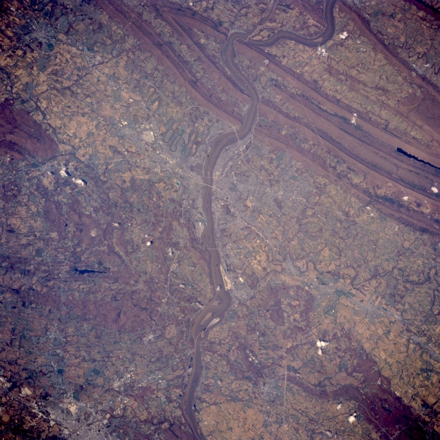 |
| STS059-217-074 Harrisburg Area, Pennsylvania April 1994 The southeasterly flowing Susquehanna River bisects this image vertically as it passes the capital city of Pennsylvania, Harrisburg (located on the east bank of the river near the center of the image). Even though the street patterns of Harrisburg and the surrounding towns are not observed, several highways (thin, light-colored lines) can be traced across the rural landscape and to a lesser degree, some of the urban areas routes can also be seen. These highways include Interstate Highway 81, US Highway 322, and the Pennsylvania Turnpike (Interstate Highway 76). The linear, light-colored feature along the east bank of the Susquehanna River is Harrisburg International Airport (formerly Olmstead Air Force Base). The bright feature about 7 miles (11 km) west of Harrisburg is the reflection off of the rooftops at the Mechanicsburg Naval Supply Depot. Brownish-looking terrain in this image tends to be forested uplands consisting of low mountains, ridgelines, and hills. A section of the Blue Mountains (several paralleling ridges) are the northern border of the broad Cumberland Valley. Clarks Creek Reservoir is the narrow dark object in a valley between two ridges (middle right edge). The southern boundary of the valley is less defined, however, by low ridges and hilly terrain. Conewago Lake is the small dark feature northwest of York, Pennsylvania in the lower left corner. |
| Images: | Images: | NO IMAGES YET | |||
| Mission: | STS059 |
||||
| Roll - Frame: | 217 - 74 |
||||
| Geographical Name: | USA-PENNSYLVANIA |
||||
| Features: | HARRISBURG,YORK,CARLISLE |
||||
| Center Lat x Lon: | 40.5N x 77W |
||||
| Film Exposure: | N | N=Normal exposure, U=Under exposed, O=Over exposed, F=out of Focus |
|||
| Percentage of Cloud Cover-CLDP: | 0 |
||||
| Camera:: | HB |
||||
| Camera Tilt: | NV | LO=Low Oblique, HO=High Oblique, NV=Near Vertical |
|||
| Camera Focal Length: | 250 |
||||
| Nadir to Photo Center Direction: | N | The direction from the nadir to the center point, N=North, S=South, E=East, W=West |
|||
| Stereo?: | Y | Y=Yes there is an adjacent picture of the same area, N=No there isn't |
|||
| Orbit Number: | 86 |
||||
| Date: | 19940414 | YYYYMMDD |
|||
| Time: | 172318 | GMT HHMMSS |
|||
| Nadir Lat: | 39.3N |
Latitude of suborbital point of spacecraft | |||
| Nadir Lon: | 76.9W |
Longitude of suborbital point of spacecraft | |||
| Sun Azimuth: | 188 | Clockwise angle in degrees from north to the sun measured at the nadir point |
|||
| Space Craft Altitude: | 115 | nautical miles |
|||
| Sun Elevation: | 60 | Angle in degrees between the horizon and the sun, measured at the nadir point |
|||
| Land Views: | MOUNTAIN, VALLEY |
||||
| Water Views: | RIVER, LAKE |
||||
| Atmosphere Views: | |
||||
| Man Made Views: | URBAN AREA, HIGHWAY, AIRPORT |
||||
| City Views: | |
||||
Photo is not associated with any sequences | |||||
| NASA Home Page |
JSC Home Page |
JSC Digital Image Collection |
Earth Science & Remote Sensing |
|
This service is provided by the International Space Station program and the JSC Earth Science & Remote Sensing Unit, ARES Division, Exploration Integration Science Directorate.

|