Geographic Region: USA-KANSAS
Feature: EMPORIA AREA
|
Geographic Region: USA-KANSAS Feature: EMPORIA AREA |
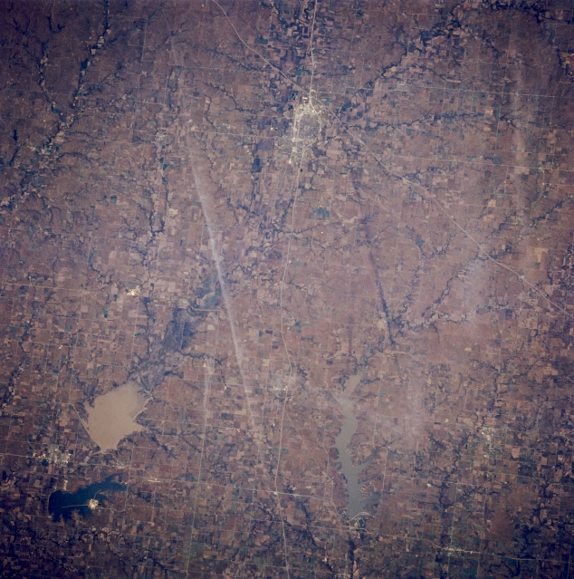 |
| STS058-088-047 Emporia and John Redmond Reservoir, Kansas, U.S.A. October 1993 Emporia and silt-laden John Redmond Reservoir (lower left), part of which is included in the Flint Hills National Wildlife Refuge, are visible in this west-looking, low-oblique photograph. Located in the Flint Hills between the Neosho and Cottonwood Rivers, Emporia is a commercial and shipping center for the surrounding cattle and farm region. The city has grain elevators; stockyards; industries processing beef and soybeans; and plants producing printing equipment, baked goods, cheese, and steel tanks. Emporia is the home of William Allen White who made the Emporia Gazette a nationally known newspaper. Northeast-southwest-oriented Interstate Highway 35 cuts through the western edge of the city. |
| Images: | Images: | NO IMAGES YET | |||
| Mission: | STS058 |
||||
| Roll - Frame: | 88 - 47 |
||||
| Geographical Name: | USA-KANSAS |
||||
| Features: | EMPORIA AREA |
||||
| Center Lat x Lon: | 38.5N x 96W |
||||
| Film Exposure: | N | N=Normal exposure, U=Under exposed, O=Over exposed, F=out of Focus |
|||
| Percentage of Cloud Cover-CLDP: | 0 |
||||
| Camera:: | HB |
||||
| Camera Tilt: | 14 | LO=Low Oblique, HO=High Oblique, NV=Near Vertical |
|||
| Camera Focal Length: | 250 |
||||
| Nadir to Photo Center Direction: | SW | The direction from the nadir to the center point, N=North, S=South, E=East, W=West |
|||
| Stereo?: | Y | Y=Yes there is an adjacent picture of the same area, N=No there isn't |
|||
| Orbit Number: | 66 |
||||
| Date: | 19931022 | YYYYMMDD |
|||
| Time: | 164231 | GMT HHMMSS |
|||
| Nadir Lat: | 39.0N |
Latitude of suborbital point of spacecraft | |||
| Nadir Lon: | 95.6W |
Longitude of suborbital point of spacecraft | |||
| Sun Azimuth: | 154 | Clockwise angle in degrees from north to the sun measured at the nadir point |
|||
| Space Craft Altitude: | 155 | nautical miles |
|||
| Sun Elevation: | 36 | Angle in degrees between the horizon and the sun, measured at the nadir point |
|||
| Land Views: | PLAIN |
||||
| Water Views: | LAKE |
||||
| Atmosphere Views: | |
||||
| Man Made Views: | URBAN AREA, AGRICULTURE |
||||
| City Views: | |
||||
Photo is not associated with any sequences | |||||
| NASA Home Page |
JSC Home Page |
JSC Digital Image Collection |
Earth Science & Remote Sensing |
|
This service is provided by the International Space Station program and the JSC Earth Science & Remote Sensing Unit, ARES Division, Exploration Integration Science Directorate.

|