Geographic Region: USA-TEXAS
Feature: RICHLAND CHAMBERS RES., TRINITY RIVER
|
Geographic Region: USA-TEXAS Feature: RICHLAND CHAMBERS RES., TRINITY RIVER |
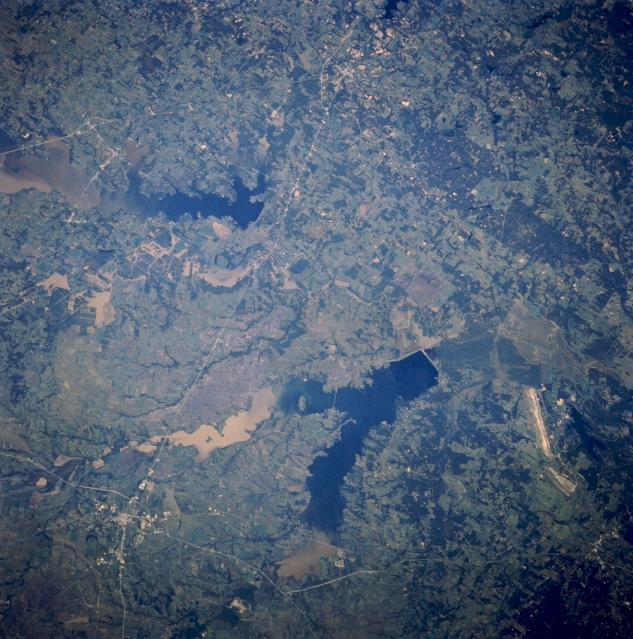 |
| STS058-080-035 Richland Creek Reservoir, Texas, U.S.A. October 1993 Two large reservoirs dominate this photograph of low, rolling hills near Corsicana--Y-shaped Richland Creek Reservoir southeast of Corsicana and, to its northeast, elongated Cedar Creek Reservoir between Corsicana and Athens--with muddy sediment (lighter water) apparent in the upper reaches of both. Barely discernible is a section of the Trinity River that flows southward between the two reservoirs. Corsicana lies at the intersection of north-south-oriented Interstate Highway 45 and Texas Highway 31 (lower left corner). Texas Highway 31 connects Corsicana and Athens (near the top center). Apparent south of Richland Creek Reservoir are a lignite strip mine operation and a small, dark lake. |
| Images: | Images: | NO IMAGES YET | |||
| Mission: | STS058 |
||||
| Roll - Frame: | 80 - 35 |
||||
| Geographical Name: | USA-TEXAS |
||||
| Features: | RICHLAND CHAMBERS RES., TRINITY RIVER |
||||
| Center Lat x Lon: | 32.0N x 96W |
||||
| Film Exposure: | N | N=Normal exposure, U=Under exposed, O=Over exposed, F=out of Focus |
|||
| Percentage of Cloud Cover-CLDP: | 0 |
||||
| Camera:: | HB |
||||
| Camera Tilt: | 29 | LO=Low Oblique, HO=High Oblique, NV=Near Vertical |
|||
| Camera Focal Length: | 250 |
||||
| Nadir to Photo Center Direction: | E | The direction from the nadir to the center point, N=North, S=South, E=East, W=West |
|||
| Stereo?: | N | Y=Yes there is an adjacent picture of the same area, N=No there isn't |
|||
| Orbit Number: | 68 |
||||
| Date: | 19931022 | YYYYMMDD |
|||
| Time: | 195213 | GMT HHMMSS |
|||
| Nadir Lat: | 31.6N |
Latitude of suborbital point of spacecraft | |||
| Nadir Lon: | 97.4W |
Longitude of suborbital point of spacecraft | |||
| Sun Azimuth: | 213 | Clockwise angle in degrees from north to the sun measured at the nadir point |
|||
| Space Craft Altitude: | 155 | nautical miles |
|||
| Sun Elevation: | 41 | Angle in degrees between the horizon and the sun, measured at the nadir point |
|||
| Land Views: | RANGE, PLAIN |
||||
| Water Views: | RESERVOIR, RIVER |
||||
| Atmosphere Views: | |
||||
| Man Made Views: | MINING, HIGHWAY, DAM |
||||
| City Views: | |
||||
Photo is not associated with any sequences | |||||
| NASA Home Page |
JSC Home Page |
JSC Digital Image Collection |
Earth Science & Remote Sensing |
|
This service is provided by the International Space Station program and the JSC Earth Science & Remote Sensing Unit, ARES Division, Exploration Integration Science Directorate.

|