Geographic Region: USA-SOUTH CAROLINA
Feature: CLARK HILL RESERVIOR
|
Geographic Region: USA-SOUTH CAROLINA Feature: CLARK HILL RESERVIOR |
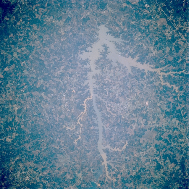 |
| ST056-076-007 Clark Hill Reservoir, Georgia, U.S.A. April 1993 Clark Hill Reservoir, one of the largest reservoirs on the Savannah River, lies northwest of Augusta and forms part of the Georgia-South Carolina border. The lake, surrounded by light-colored forested lands, receives sediment from numerous tributary streams. Thin, linear Interstate Highway 20 is apparent south of the lake (right corner). |
| Images: | Images: | NO IMAGES YET | |||
| Mission: | STS056 |
||||
| Roll - Frame: | 76 - 7 |
||||
| Geographical Name: | USA-SOUTH CAROLINA |
||||
| Features: | CLARK HILL RESERVIOR |
||||
| Center Lat x Lon: | 34.0N x 82.5W |
||||
| Film Exposure: | N | N=Normal exposure, U=Under exposed, O=Over exposed, F=out of Focus |
|||
| Percentage of Cloud Cover-CLDP: | 0 |
||||
| Camera:: | HB |
||||
| Camera Tilt: | 2 | LO=Low Oblique, HO=High Oblique, NV=Near Vertical |
|||
| Camera Focal Length: | 250 |
||||
| Nadir to Photo Center Direction: | E | The direction from the nadir to the center point, N=North, S=South, E=East, W=West |
|||
| Stereo?: | N | Y=Yes there is an adjacent picture of the same area, N=No there isn't |
|||
| Orbit Number: | 38 |
||||
| Date: | 19930410 | YYYYMMDD |
|||
| Time: | 134422 | GMT HHMMSS |
|||
| Nadir Lat: | 34.0N |
Latitude of suborbital point of spacecraft | |||
| Nadir Lon: | 82.6W |
Longitude of suborbital point of spacecraft | |||
| Sun Azimuth: | 102 | Clockwise angle in degrees from north to the sun measured at the nadir point |
|||
| Space Craft Altitude: | 162 | nautical miles |
|||
| Sun Elevation: | 32 | Angle in degrees between the horizon and the sun, measured at the nadir point |
|||
| Land Views: | FOREST |
||||
| Water Views: | RESERVOIR, SEDIMENT, RIVER |
||||
| Atmosphere Views: | |
||||
| Man Made Views: | |
||||
| City Views: | |
||||
Photo is not associated with any sequences | |||||
| NASA Home Page |
JSC Home Page |
JSC Digital Image Collection |
Earth Science & Remote Sensing |
|
This service is provided by the International Space Station program and the JSC Earth Science & Remote Sensing Unit, ARES Division, Exploration Integration Science Directorate.

|