Geographic Region: ARGENTINA
Feature: CENTRAL ANDES, TEUCO R.
|
Geographic Region: ARGENTINA Feature: CENTRAL ANDES, TEUCO R. |
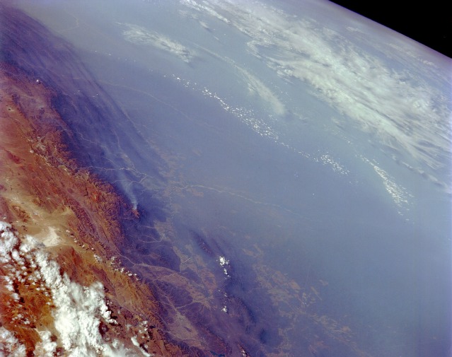 |
| STS048-151-137 Smoke, South-Central Bolivia September 1991 The extensive smoke pall shown in this high-oblique, northeast-looking photograph of southern Bolivia is typical of palls that can extend for thousands of square miles (thousands of square kilometers) in Brazil, Paraguay, and Bolivia. The smoke palls are most widespread during the dry winter months when vegetated areas are cleared for slash-and-burn agriculture--crop cultivation in recently cut and burned tropical vegetation clearings that are soon abandoned in favor of newly burned land. The darker, vegetated parallel ridges (western edge of the photograph) are the foothills of the Andes Mountains that give way to the higher elevations (brown area) further west, which act as a barrier to the westward movement of smoke throughout South America. The Pilcomayo River is visible (center of photograph) as it emerges from the foothills of the Andes Mountains near the town of Villa Montes. Large cultivated field patterns appear in some of the valleys in the foothills and in the lowlands adjacent to the eastern flank of the foothills. |
| Images: | Images: | NO IMAGES YET | |||
| Mission: | STS048 |
||||
| Roll - Frame: | 151 - 137 |
||||
| Geographical Name: | ARGENTINA |
||||
| Features: | CENTRAL ANDES, TEUCO R. |
||||
| Center Lat x Lon: | 24S x 63W |
||||
| Film Exposure: | N | N=Normal exposure, U=Under exposed, O=Over exposed, F=out of Focus |
|||
| Percentage of Cloud Cover-CLDP: | 20 |
||||
| Camera:: | LH |
||||
| Camera Tilt: | HO | LO=Low Oblique, HO=High Oblique, NV=Near Vertical |
|||
| Camera Focal Length: | 250 |
||||
| Nadir to Photo Center Direction: | E | The direction from the nadir to the center point, N=North, S=South, E=East, W=West |
|||
| Stereo?: | N | Y=Yes there is an adjacent picture of the same area, N=No there isn't |
|||
| Orbit Number: | 13 |
||||
| Date: | 19910913 | YYYYMMDD |
|||
| Time: | 193654 | GMT HHMMSS |
|||
| Nadir Lat: | 27.8S |
Latitude of suborbital point of spacecraft | |||
| Nadir Lon: | 70.7W |
Longitude of suborbital point of spacecraft | |||
| Sun Azimuth: | 299 | Clockwise angle in degrees from north to the sun measured at the nadir point |
|||
| Space Craft Altitude: | 294 | nautical miles |
|||
| Sun Elevation: | 37 | Angle in degrees between the horizon and the sun, measured at the nadir point |
|||
| Land Views: | MOUNTAIN, BASIN |
||||
| Water Views: | |
||||
| Atmosphere Views: | SMOKE |
||||
| Man Made Views: | |
||||
| City Views: | |
||||
Photo is not associated with any sequences | |||||
| NASA Home Page |
JSC Home Page |
JSC Digital Image Collection |
Earth Science & Remote Sensing |
|
This service is provided by the International Space Station program and the JSC Earth Science & Remote Sensing Unit, ARES Division, Exploration Integration Science Directorate.

|