Geographic Region: FRANCE
Feature: LE HAVRE AREA
|
Geographic Region: FRANCE Feature: LE HAVRE AREA |
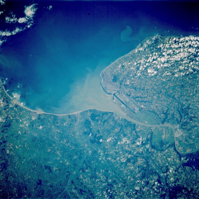 |
| STS047-094-006 Le Havre, France September 1992 The city of Le Havre, located on the northwest coast of France, is a major seaport and window to the world for France. Located on the north side of the Seine River estuary, Le Havre, with a population that exceeds 200 000, is a key port for transatlantic passenger service, as well as a transshipment center for oceangoing freight. A large percentage of the labor force in this region of France is involved in the movement of manufactured goods and people into and out of France. A ferry line connects Le Havre with Southampton, England, and the city has an excellent harbor and fine shipbuilding facilities. Outside the city, agriculture is the predominant occupation; wheat is a major crop. This area is part of the much larger region known as the lowlands of north-central Europe, a highly productive farm belt. |
| Images: | Images: | NO IMAGES YET | |||
| Mission: | STS047 |
||||
| Roll - Frame: | 94 - 6 |
||||
| Geographical Name: | FRANCE |
||||
| Features: | LE HAVRE AREA |
||||
| Center Lat x Lon: | 49.5N x .0E |
||||
| Film Exposure: | N | N=Normal exposure, U=Under exposed, O=Over exposed, F=out of Focus |
|||
| Percentage of Cloud Cover-CLDP: | 20 |
||||
| Camera:: | HB |
||||
| Camera Tilt: | 20 | LO=Low Oblique, HO=High Oblique, NV=Near Vertical |
|||
| Camera Focal Length: | 250 |
||||
| Nadir to Photo Center Direction: | W | The direction from the nadir to the center point, N=North, S=South, E=East, W=West |
|||
| Stereo?: | Y | Y=Yes there is an adjacent picture of the same area, N=No there isn't |
|||
| Orbit Number: | 49 |
||||
| Date: | 19920915 | YYYYMMDD |
|||
| Time: | 151538 | GMT HHMMSS |
|||
| Nadir Lat: | 49.3N |
Latitude of suborbital point of spacecraft | |||
| Nadir Lon: | 1.0E |
Longitude of suborbital point of spacecraft | |||
| Sun Azimuth: | 240 | Clockwise angle in degrees from north to the sun measured at the nadir point |
|||
| Space Craft Altitude: | 170 | nautical miles |
|||
| Sun Elevation: | 26 | Angle in degrees between the horizon and the sun, measured at the nadir point |
|||
| Land Views: | COAST, PLAIN |
||||
| Water Views: | RIVER, SEDIMENT |
||||
| Atmosphere Views: | |
||||
| Man Made Views: | URBAN AREA |
||||
| City Views: | |
||||
Photo is not associated with any sequences | |||||
| NASA Home Page |
JSC Home Page |
JSC Digital Image Collection |
Earth Science & Remote Sensing |
|
This service is provided by the International Space Station program and the JSC Earth Science & Remote Sensing Unit, ARES Division, Exploration Integration Science Directorate.

|