Geographic Region: BRAZIL
Feature: RONDONIA,DEFOREST,CITY
|
Geographic Region: BRAZIL Feature: RONDONIA,DEFOREST,CITY |
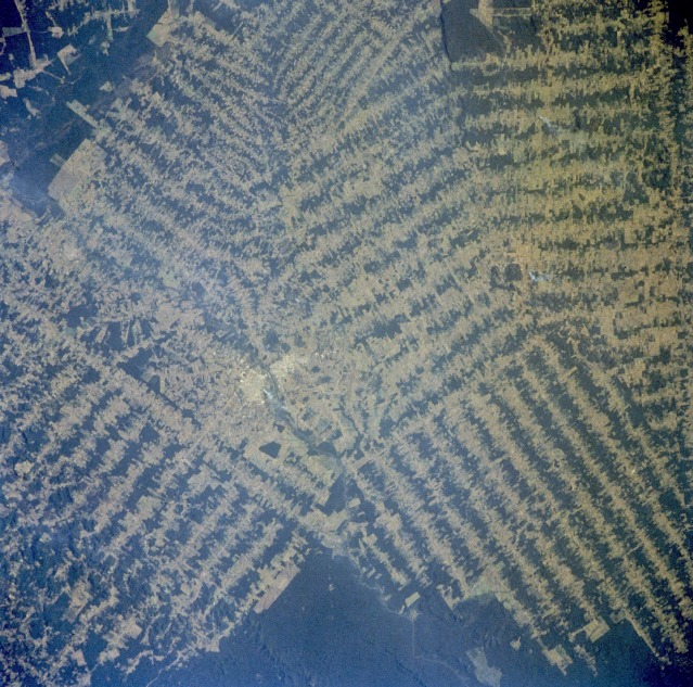 |
| STS046-078-026 Rondônia, Brazil August 1992 This photograph, showing the destruction of tropical rain forests, provides a visual indication of the rate of deforestation that is taking place in the state of Rondônia, which has been especially hard hit by deforestation. The amount of clear-cut area now exceeds the area of remaining rain forest timber stands. The solid dark green areas show the remaining tropical rain forest canopy. Two urban areas separated by a small river can be seen near the center of the photograph. This photograph and photograph STS-51G-034-0060, taken 7 years earlier, are representative of much larger areas where tropical rain forests are being decimated to permit farming and grazing in Brazil, Central America, Africa, Asia, and Australia. |
| Images: | Images: | NO IMAGES YET | |||
| Mission: | STS046 |
||||
| Roll - Frame: | 78 - 26 |
||||
| Geographical Name: | BRAZIL |
||||
| Features: | RONDONIA,DEFOREST,CITY |
||||
| Center Lat x Lon: | N x E |
||||
| Film Exposure: | N | N=Normal exposure, U=Under exposed, O=Over exposed, F=out of Focus |
|||
| Percentage of Cloud Cover-CLDP: | 0 |
||||
| Camera:: | HB |
||||
| Camera Tilt: | LO | LO=Low Oblique, HO=High Oblique, NV=Near Vertical |
|||
| Camera Focal Length: | 250 |
||||
| Nadir to Photo Center Direction: | The direction from the nadir to the center point, N=North, S=South, E=East, W=West |
||||
| Stereo?: | N | Y=Yes there is an adjacent picture of the same area, N=No there isn't |
|||
| Orbit Number: | 35 |
||||
| Date: | 19920802 | YYYYMMDD |
|||
| Time: | 191034 | GMT HHMMSS |
|||
| Nadir Lat: | 11.7S |
Latitude of suborbital point of spacecraft | |||
| Nadir Lon: | 61.8W |
Longitude of suborbital point of spacecraft | |||
| Sun Azimuth: | 303 | Clockwise angle in degrees from north to the sun measured at the nadir point |
|||
| Space Craft Altitude: | 232 | nautical miles |
|||
| Sun Elevation: | 39 | Angle in degrees between the horizon and the sun, measured at the nadir point |
|||
| Land Views: | FOREST, BASIN |
||||
| Water Views: | RIVER |
||||
| Atmosphere Views: | |
||||
| Man Made Views: | DEFORESTATION |
||||
| City Views: | |
||||
Associated Photos in Sequence:  Photo #: STS51G-34-60 Photo #: STS51G-34-60Description: BRAZIL, AMAZON BASIN-1985; DEFORESTATION PATTERNS Sequence ID: 7A  Photo #: STS046-78-26 ** Currently displayed photo ** Photo #: STS046-78-26 ** Currently displayed photo ** Description: BRAZIL, AMAZON BASIN-1992; CHANGING DEFORESTATION PATTERNS Sequence ID: 7B  Photo #: STS046-80-36 Photo #: STS046-80-36Description: BRAZIL, AMAZON BASIN-1992; CHANGING DEFORESTATION PATTERNS Sequence ID: 7C | |||||
| NASA Home Page |
JSC Home Page |
JSC Digital Image Collection |
Earth Science & Remote Sensing |
|
This service is provided by the International Space Station program and the JSC Earth Science & Remote Sensing Unit, ARES Division, Exploration Integration Science Directorate.

|