Geographic Region: JAPAN
Feature: N. HONSHU, SENDAI
|
Geographic Region: JAPAN Feature: N. HONSHU, SENDAI |
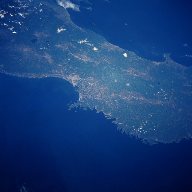 |
| STS040-610-030 Sendai Coast, Honshu, Japan June 1991 The physical landscape of the north central section of Honshu Island is shown in this west-looking view. The darker areas on the image identify the vegetated mountains and the lighter areas indicate coastal plains and isolated intermontane valleys where the urban areas are located. A limited amount of farming is carried out where topographic conditions permit. The dark, roughly oval-shaped feature (near upper left corner) is Inawashiro Lake, while the smaller less obvious oval feature (middle right-east of Oga Peninsula) is Lake Tazawa, a circular caldera that is the deepest lake in Japan (1388 feet-423 meters). Sendai Bay is the large, smooth coastline along the east side of Honshu, while the coastline north of this bay becomes more serrated-looking. The two "white spots" (oval, whiter features) near the central west coast are snow capped Mt. Chokai (northernmost)-7316 feet-2330 meters and Mt. Gassan- 6496 feet-1980 meters above sea level. |
| Images: | Images: | NO IMAGES YET | |||
| Mission: | STS040 |
||||
| Roll - Frame: | 610 - 30 |
||||
| Geographical Name: | JAPAN |
||||
| Features: | N. HONSHU, SENDAI |
||||
| Center Lat x Lon: | 39.0N x 141.5E |
||||
| Film Exposure: | N | N=Normal exposure, U=Under exposed, O=Over exposed, F=out of Focus |
|||
| Percentage of Cloud Cover-CLDP: | 0 |
||||
| Camera:: | RX |
||||
| Camera Tilt: | LO | LO=Low Oblique, HO=High Oblique, NV=Near Vertical |
|||
| Camera Focal Length: | 100 |
||||
| Nadir to Photo Center Direction: | The direction from the nadir to the center point, N=North, S=South, E=East, W=West |
||||
| Stereo?: | N | Y=Yes there is an adjacent picture of the same area, N=No there isn't |
|||
| Orbit Number: | |
||||
| Date: | 199106__ | YYYYMMDD |
|||
| Time: | GMT HHMMSS |
||||
| Nadir Lat: | N |
Latitude of suborbital point of spacecraft | |||
| Nadir Lon: | E |
Longitude of suborbital point of spacecraft | |||
| Sun Azimuth: | Clockwise angle in degrees from north to the sun measured at the nadir point |
||||
| Space Craft Altitude: | nautical miles |
||||
| Sun Elevation: | Angle in degrees between the horizon and the sun, measured at the nadir point |
||||
| Land Views: | PLAIN, MOUNTAIN |
||||
| Water Views: | LAKE |
||||
| Atmosphere Views: | |
||||
| Man Made Views: | |
||||
| City Views: | |
||||
Photo is not associated with any sequences | |||||
| NASA Home Page |
JSC Home Page |
JSC Digital Image Collection |
Earth Science & Remote Sensing |
|
This service is provided by the International Space Station program and the JSC Earth Science & Remote Sensing Unit, ARES Division, Exploration Integration Science Directorate.

|