Geographic Region: USA-NEW MEXICO
Feature: PANORAMA,NM. TO MEXICO
|
Geographic Region: USA-NEW MEXICO Feature: PANORAMA,NM. TO MEXICO |
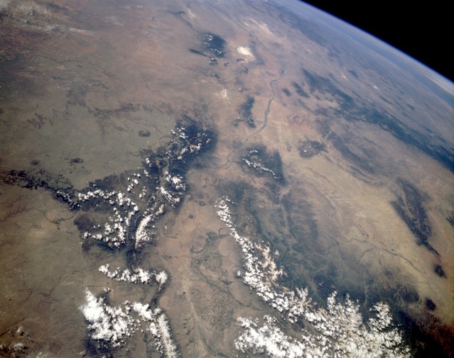 |
| STS040-151-023 Southern Rocky Mountains, New Mexico, U.S.A. June 1991 This panoramic, south-looking photograph captures the physiographic relationship between the southern extent of the Rocky Mountains and the desert environment of south-central Colorado and most of New Mexico. In this photograph, the Rio Grande Rift Valley can be traced from its source in the San Juan Mountains of Colorado, through the San Luis Valley, and then southward until it starts to bend southeast and runs through the same mountain pass in which El Paso, Texas, is located. In the bottom center of the photograph, hundreds of center-pivot irrigation field patterns are visible in the vicinity of Alamosa, Colorado. The wide Rio Grande Rift Valley is flanked by the Sangre de Cristo Range to the east and the San Juan Mountains to the west. Farther to the west, several tributaries of the San Juan River are visible near Farmington, New Mexico. As the Rio Grande flows south, it passes the city of Albuquerque, New Mexico, and White Sands National Monument (near the top center of the photograph). The large uniform-looking region to the east of the Sangre de Cristo Range is a plateau where water erosion is slowly creating several large canyons. |
| Images: | Images: | NO IMAGES YET | |||
| Mission: | STS040 |
||||
| Roll - Frame: | 151 - 23 |
||||
| Geographical Name: | USA-NEW MEXICO |
||||
| Features: | PANORAMA,NM. TO MEXICO |
||||
| Center Lat x Lon: | 36.0N x 106W |
||||
| Film Exposure: | N | N=Normal exposure, U=Under exposed, O=Over exposed, F=out of Focus |
|||
| Percentage of Cloud Cover-CLDP: | 0 |
||||
| Camera:: | LH |
||||
| Camera Tilt: | HO | LO=Low Oblique, HO=High Oblique, NV=Near Vertical |
|||
| Camera Focal Length: | 90 |
||||
| Nadir to Photo Center Direction: | S | The direction from the nadir to the center point, N=North, S=South, E=East, W=West |
|||
| Stereo?: | N | Y=Yes there is an adjacent picture of the same area, N=No there isn't |
|||
| Orbit Number: | 35 |
||||
| Date: | 19910607 | YYYYMMDD |
|||
| Time: | 164321 | GMT HHMMSS |
|||
| Nadir Lat: | 38.8N |
Latitude of suborbital point of spacecraft | |||
| Nadir Lon: | 105.2W |
Longitude of suborbital point of spacecraft | |||
| Sun Azimuth: | 108 | Clockwise angle in degrees from north to the sun measured at the nadir point |
|||
| Space Craft Altitude: | 155 | nautical miles |
|||
| Sun Elevation: | 56 | Angle in degrees between the horizon and the sun, measured at the nadir point |
|||
| Land Views: | BASIN, DESERT, FOREST, MOUNTAIN, PLAIN, PLATEAU, RANGE, VALLEY |
||||
| Water Views: | RIVER |
||||
| Atmosphere Views: | |
||||
| Man Made Views: | AGRICULTURE, PIVOT IRRIGATION |
||||
| City Views: | |
||||
Photo is not associated with any sequences | |||||
| NASA Home Page |
JSC Home Page |
JSC Digital Image Collection |
Earth Science & Remote Sensing |
|
This service is provided by the International Space Station program and the JSC Earth Science & Remote Sensing Unit, ARES Division, Exploration Integration Science Directorate.

|