Geographic Region: RUSSIAN FEDERATION
Feature: LAKE BAIKAL-SVYATOYNOS P
|
Geographic Region: RUSSIAN FEDERATION Feature: LAKE BAIKAL-SVYATOYNOS P |
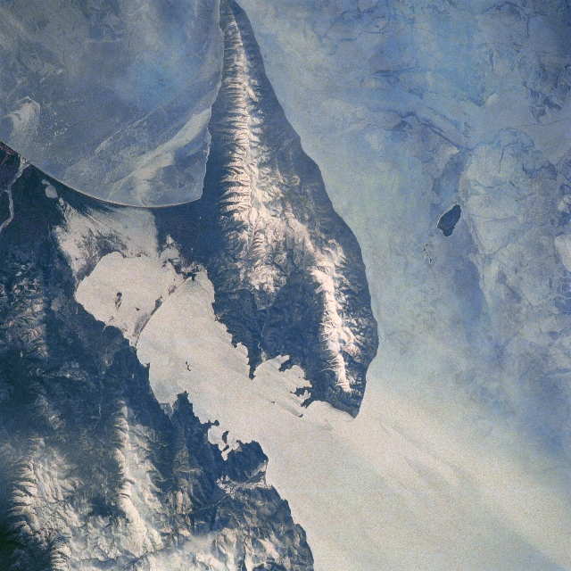 |
| STS039-077-073 Svyatoy Peninsula and Lake Baykal, Russia May 1991 Even though this image was collected during the spring of 1991, the snow-covered mountainous landscape and ice-covered (extensive, light-colored surfaces) Lake Baykal presents a harsh-looking, cold environment. The wedge-shaped mountainous terrain with several snow capped peaks and ridgelines exceeding 5000 feet (1524 meters) above sea level is aligned in a northeast-southwest orientation. The dark feature west of the large, Svyatoy Peninsula is a small island that is surrounded by ice. The various patterns and color gradation within the ice that covers Lake Baykol indicates a variety of ice thicknesses. The Svyatoy Peninsula is connected to the mountainous eastern shore of the lake by a low-lying, swampy isthmus. |
| Images: | Images: | NO IMAGES YET | |||
| Mission: | STS039 |
||||
| Roll - Frame: | 77 - 73 |
||||
| Geographical Name: | RUSSIAN FEDERATION |
||||
| Features: | LAKE BAIKAL-SVYATOYNOS P |
||||
| Center Lat x Lon: | 54.0N x 109.0E |
||||
| Film Exposure: | N | N=Normal exposure, U=Under exposed, O=Over exposed, F=out of Focus |
|||
| Percentage of Cloud Cover-CLDP: | 0 |
||||
| Camera:: | HB |
||||
| Camera Tilt: | 31 | LO=Low Oblique, HO=High Oblique, NV=Near Vertical |
|||
| Camera Focal Length: | 250 |
||||
| Nadir to Photo Center Direction: | NW | The direction from the nadir to the center point, N=North, S=South, E=East, W=West |
|||
| Stereo?: | Y | Y=Yes there is an adjacent picture of the same area, N=No there isn't |
|||
| Orbit Number: | 11 |
||||
| Date: | 19910429 | YYYYMMDD |
|||
| Time: | 011352 | GMT HHMMSS |
|||
| Nadir Lat: | 52.8N |
Latitude of suborbital point of spacecraft | |||
| Nadir Lon: | 109.8E |
Longitude of suborbital point of spacecraft | |||
| Sun Azimuth: | 113 | Clockwise angle in degrees from north to the sun measured at the nadir point |
|||
| Space Craft Altitude: | 145 | nautical miles |
|||
| Sun Elevation: | 34 | Angle in degrees between the horizon and the sun, measured at the nadir point |
|||
| Land Views: | PENINSULA |
||||
| Water Views: | LAKE |
||||
| Atmosphere Views: | |
||||
| Man Made Views: | |
||||
| City Views: | |
||||
Photo is not associated with any sequences | |||||
| NASA Home Page |
JSC Home Page |
JSC Digital Image Collection |
Earth Science & Remote Sensing |
|
This service is provided by the International Space Station program and the JSC Earth Science & Remote Sensing Unit, ARES Division, Exploration Integration Science Directorate.

|