Geographic Region: USA-FLORIDA
Feature: JACKSONVILLE,ST. JOHNS R.
|
Geographic Region: USA-FLORIDA Feature: JACKSONVILLE,ST. JOHNS R. |
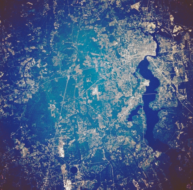 |
| STS034-074-077 Northeast Florida, U.S.A. October 1989 Man's impact on northeastern Florida is vividly documented in this low-oblique, north-looking photograph of the area surrounding Jacksonville and the extensive highway network radiating outward--north-south-oriented Interstate Highway 95, east-west-oriented Interstate Highway 10, and northeast-southwest-aligned U. S. Highway 301. Downtown Jacksonville lies along the northwest shore of the Saint Johns River at its 90deg-turn eastward. Runways of three airports are visible--Jacksonville International Airport north of the city; Cecil Field Naval Air Station southwest of the city; and Jacksonville Naval Air Station south and immediately west of the dark, wide, north-flowing Saint Johns River. Two highly reflective areas (bottom left) are probably limestone quarries. The darker features scattered across the low-lying, flat terrain are wooded swamps. |
| Images: | Images: | NO IMAGES YET | |||
| Mission: | STS034 |
||||
| Roll - Frame: | 74 - 77 |
||||
| Geographical Name: | USA-FLORIDA |
||||
| Features: | JACKSONVILLE,ST. JOHNS R. |
||||
| Center Lat x Lon: | 30.0N x 82W |
||||
| Film Exposure: | N | N=Normal exposure, U=Under exposed, O=Over exposed, F=out of Focus |
|||
| Percentage of Cloud Cover-CLDP: | 0 |
||||
| Camera:: | HB |
||||
| Camera Tilt: | 14 | LO=Low Oblique, HO=High Oblique, NV=Near Vertical |
|||
| Camera Focal Length: | 250 |
||||
| Nadir to Photo Center Direction: | SE | The direction from the nadir to the center point, N=North, S=South, E=East, W=West |
|||
| Stereo?: | N | Y=Yes there is an adjacent picture of the same area, N=No there isn't |
|||
| Orbit Number: | 66 |
||||
| Date: | 19891022 | YYYYMMDD |
|||
| Time: | 192643 | GMT HHMMSS |
|||
| Nadir Lat: | 30.6N |
Latitude of suborbital point of spacecraft | |||
| Nadir Lon: | 82.4W |
Longitude of suborbital point of spacecraft | |||
| Sun Azimuth: | 222 | Clockwise angle in degrees from north to the sun measured at the nadir point |
|||
| Space Craft Altitude: | 175 | nautical miles |
|||
| Sun Elevation: | 37 | Angle in degrees between the horizon and the sun, measured at the nadir point |
|||
| Land Views: | PLAIN |
||||
| Water Views: | RIVER |
||||
| Atmosphere Views: | |
||||
| Man Made Views: | URBAN AREA, AIRPORT, HIGHWAY, MINING |
||||
| City Views: | |
||||
Photo is not associated with any sequences | |||||
| NASA Home Page |
JSC Home Page |
JSC Digital Image Collection |
Earth Science & Remote Sensing |
|
This service is provided by the International Space Station program and the JSC Earth Science & Remote Sensing Unit, ARES Division, Exploration Integration Science Directorate.

|