Geographic Region: USA-ALASKA
Feature: KUIU ISLAND
|
Geographic Region: USA-ALASKA Feature: KUIU ISLAND |
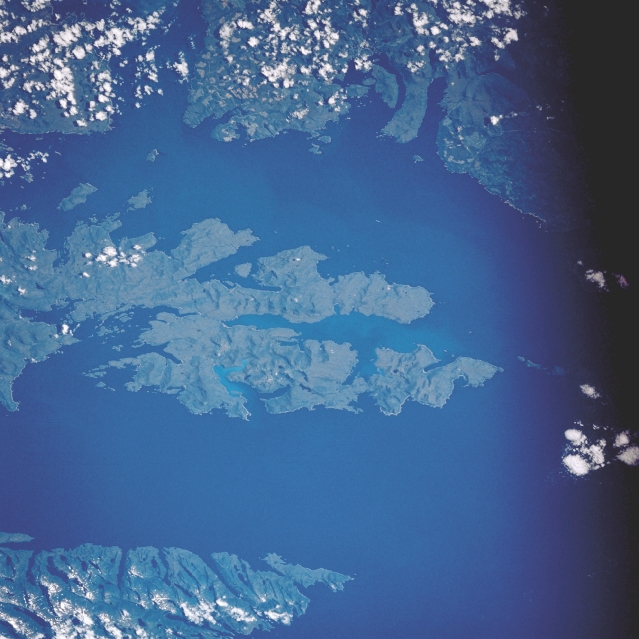 |
| STS028-082-041 Kuiu Island, Alaska, U.S.A. August 1989 This photograph features the southern two-thirds of forested Kuiu Island, an undeveloped island flanked by Chatham Strait on the west and partially bordered by Sumner Strait on the east. |
| Images: | Images: | NO IMAGES YET | |||
| Mission: | STS028 |
||||
| Roll - Frame: | 82 - 41 |
||||
| Geographical Name: | USA-ALASKA |
||||
| Features: | KUIU ISLAND |
||||
| Center Lat x Lon: | 56.0N x 134W |
||||
| Film Exposure: | N | N=Normal exposure, U=Under exposed, O=Over exposed, F=out of Focus |
|||
| Percentage of Cloud Cover-CLDP: | 20 |
||||
| Camera:: | HB |
||||
| Camera Tilt: | 45 | LO=Low Oblique, HO=High Oblique, NV=Near Vertical |
|||
| Camera Focal Length: | 250 |
||||
| Nadir to Photo Center Direction: | W | The direction from the nadir to the center point, N=North, S=South, E=East, W=West |
|||
| Stereo?: | N | Y=Yes there is an adjacent picture of the same area, N=No there isn't |
|||
| Orbit Number: | 21 |
||||
| Date: | 19890809 | YYYYMMDD |
|||
| Time: | 190350 | GMT HHMMSS |
|||
| Nadir Lat: | 55.9N |
Latitude of suborbital point of spacecraft | |||
| Nadir Lon: | 131.3W |
Longitude of suborbital point of spacecraft | |||
| Sun Azimuth: | 142 | Clockwise angle in degrees from north to the sun measured at the nadir point |
|||
| Space Craft Altitude: | 161 | nautical miles |
|||
| Sun Elevation: | 45 | Angle in degrees between the horizon and the sun, measured at the nadir point |
|||
| Land Views: | ISLAND |
||||
| Water Views: | |
||||
| Atmosphere Views: | |
||||
| Man Made Views: | |
||||
| City Views: | |
||||
Photo is not associated with any sequences | |||||
| NASA Home Page |
JSC Home Page |
JSC Digital Image Collection |
Earth Science & Remote Sensing |
|
This service is provided by the International Space Station program and the JSC Earth Science & Remote Sensing Unit, ARES Division, Exploration Integration Science Directorate.

|