Geographic Region: CANADA-M
Feature: NELSON R, HUDSON BAY
|
Geographic Region: CANADA-M Feature: NELSON R, HUDSON BAY |
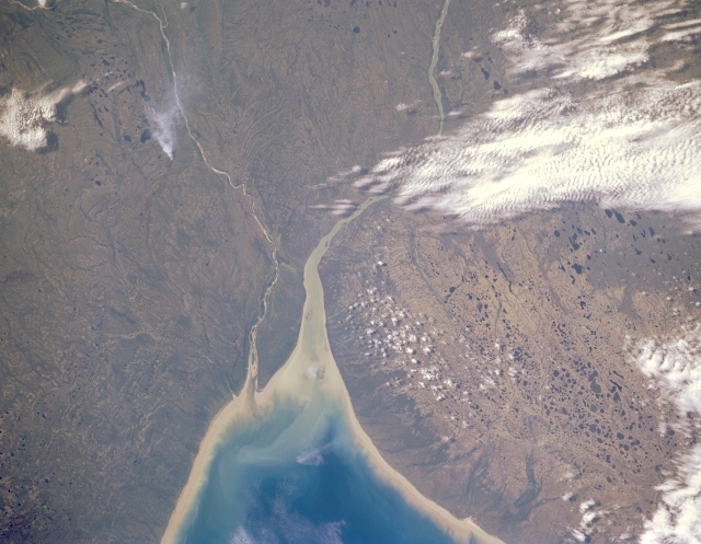 |
| STS028-152-149 Nelson River, Manitoba, Canada August 1989 The Nelson River (larger, westerly) and the Hayes River (smaller, southwesterly) form a small peninsula that extends modestly into the southwest side of Hudson Bay. In this image there is no hint of human development or activity with the possible exception of a single smoke plume east of the Hayes River. But even the fire could have been started earlier by a lightning strike from a passing thunderstorm. The lighter colored shorelines east and north of the mouths of these rivers are sandy beaches. The spongy pattern made by a multitude of small lakes (dark features) shows the boggy landscape that is prevalent around Hudson Bay. |
| Images: | Images: | NO IMAGES YET | |||
| Mission: | STS028 |
||||
| Roll - Frame: | 152 - 149 |
||||
| Geographical Name: | CANADA-M |
||||
| Features: | NELSON R, HUDSON BAY |
||||
| Center Lat x Lon: | 57.0N x 93W |
||||
| Film Exposure: | N | N=Normal exposure, U=Under exposed, O=Over exposed, F=out of Focus |
|||
| Percentage of Cloud Cover-CLDP: | 30 |
||||
| Camera:: | LH |
||||
| Camera Tilt: | 32 | LO=Low Oblique, HO=High Oblique, NV=Near Vertical |
|||
| Camera Focal Length: | 250 |
||||
| Nadir to Photo Center Direction: | E | The direction from the nadir to the center point, N=North, S=South, E=East, W=West |
|||
| Stereo?: | N | Y=Yes there is an adjacent picture of the same area, N=No there isn't |
|||
| Orbit Number: | 36 |
||||
| Date: | 19890810 | YYYYMMDD |
|||
| Time: | 174447 | GMT HHMMSS |
|||
| Nadir Lat: | 57.1N |
Latitude of suborbital point of spacecraft | |||
| Nadir Lon: | 94.7W |
Longitude of suborbital point of spacecraft | |||
| Sun Azimuth: | 166 | Clockwise angle in degrees from north to the sun measured at the nadir point |
|||
| Space Craft Altitude: | 161 | nautical miles |
|||
| Sun Elevation: | 48 | Angle in degrees between the horizon and the sun, measured at the nadir point |
|||
| Land Views: | |
||||
| Water Views: | RIVER, BAY, LAKE |
||||
| Atmosphere Views: | |
||||
| Man Made Views: | |
||||
| City Views: | |
||||
Photo is not associated with any sequences | |||||
| NASA Home Page |
JSC Home Page |
JSC Digital Image Collection |
Earth Science & Remote Sensing |
|
This service is provided by the International Space Station program and the JSC Earth Science & Remote Sensing Unit, ARES Division, Exploration Integration Science Directorate.

|