Geographic Region: USA-WASHINGTON
Feature: MT. RAINIER, CASCADE MTS.
|
Geographic Region: USA-WASHINGTON Feature: MT. RAINIER, CASCADE MTS. |
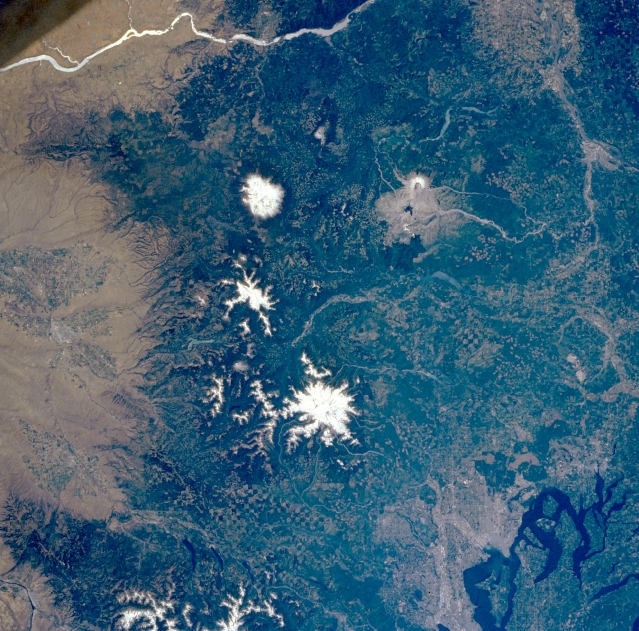 |
| NM21-770-007 Mount Saint Helens, Mount Adams, and Mount Rainier; Washington; U.S.A. Winter 1996 The southern Washington Cascade Range is visible in this near-vertical photograph. The Columbia River, separating the states of Oregon and Washington, can be seen at the top of the photograph. The second-highest peak in the Cascade Range, Mount Adams, is visible north of the river. The horseshoe-shaped summit and caldera of Mount Saint Helens and the gray blast zone from its eruption of May 18, 1980, can be seen west of Mount Adams. North of Mount Adams and Mount Saint Helens is Mount Rainier, the highest peak in the Cascade Range and the second highest peak in the contiguous United States. The streams draining Mount Saint Helens remain choked with ash from the eruption. Mount Rainier is also considered to be one of the prime volcanic hazards in the United States because of its proximity to the Tacoma-Seattle region (upper left corner). Puget Sound and the cities of Olympia, Tacoma, and Seattle are visible near the bottom right, and the city of Yakima is barely discernible near the center left. The checkerboard pattern in the forests of the Cascades is from logging clear cuts. |
| Images: | Images: | NO IMAGES YET | |||
| Mission: | NM21 |
||||
| Roll - Frame: | 770 - 7 |
||||
| Geographical Name: | USA-WASHINGTON |
||||
| Features: | MT. RAINIER, CASCADE MTS. |
||||
| Center Lat x Lon: | 46.5N x 122W |
||||
| Film Exposure: | N | N=Normal exposure, U=Under exposed, O=Over exposed, F=out of Focus |
|||
| Percentage of Cloud Cover-CLDP: | 0 |
||||
| Camera:: | HB |
||||
| Camera Tilt: | LO | LO=Low Oblique, HO=High Oblique, NV=Near Vertical |
|||
| Camera Focal Length: | 100 |
||||
| Nadir to Photo Center Direction: | N | The direction from the nadir to the center point, N=North, S=South, E=East, W=West |
|||
| Stereo?: | Y | Y=Yes there is an adjacent picture of the same area, N=No there isn't |
|||
| Orbit Number: | |
||||
| Date: | 19960706 | YYYYMMDD |
|||
| Time: | GMT HHMMSS |
||||
| Nadir Lat: | N |
Latitude of suborbital point of spacecraft | |||
| Nadir Lon: | E |
Longitude of suborbital point of spacecraft | |||
| Sun Azimuth: | Clockwise angle in degrees from north to the sun measured at the nadir point |
||||
| Space Craft Altitude: | nautical miles |
||||
| Sun Elevation: | Angle in degrees between the horizon and the sun, measured at the nadir point |
||||
| Land Views: | VOLCANO, RANGE, FOREST |
||||
| Water Views: | |
||||
| Atmosphere Views: | |
||||
| Man Made Views: | |
||||
| City Views: | |
||||
Photo is not associated with any sequences | |||||
| NASA Home Page |
JSC Home Page |
JSC Digital Image Collection |
Earth Science & Remote Sensing |
|
This service is provided by the International Space Station program and the JSC Earth Science & Remote Sensing Unit, ARES Division, Exploration Integration Science Directorate.

|