Geographic Region: CANADA-S
Feature: REGINA, AGRICULTURE
|
Geographic Region: CANADA-S Feature: REGINA, AGRICULTURE |
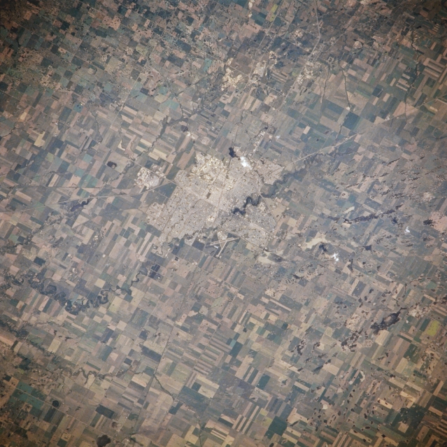 |
| NM21-768-031 Regina, Saskatchewan, Canada Spring/Summer 1996 Located in the south central part of the province, Regina has developed as a service center for the vast agricultural industry that has taken root in this section of the northern Great Plains of Northern America. The large, angular looking, cultivated fields where a number of grain crops are grown, mainly spring wheat, are visible throughout the agricultural landscape. The Wascana River winds its way through the city in a northwest-southeast orientation and the runway of Regina Airport is visible along the southwest side of the city. |
| Images: | Images: | NO IMAGES YET | |||
| Mission: | NM21 |
||||
| Roll - Frame: | 768 - 31 |
||||
| Geographical Name: | CANADA-S |
||||
| Features: | REGINA, AGRICULTURE |
||||
| Center Lat x Lon: | 50.5N x 104.5W |
||||
| Film Exposure: | N | N=Normal exposure, U=Under exposed, O=Over exposed, F=out of Focus |
|||
| Percentage of Cloud Cover-CLDP: | 5 |
||||
| Camera:: | HB |
||||
| Camera Tilt: | 25 | LO=Low Oblique, HO=High Oblique, NV=Near Vertical |
|||
| Camera Focal Length: | 250 |
||||
| Nadir to Photo Center Direction: | NW | The direction from the nadir to the center point, N=North, S=South, E=East, W=West |
|||
| Stereo?: | Y | Y=Yes there is an adjacent picture of the same area, N=No there isn't |
|||
| Orbit Number: | 55 |
||||
| Date: | 19960706 | YYYYMMDD |
|||
| Time: | 175552 | GMT HHMMSS |
|||
| Nadir Lat: | 49.1N |
Latitude of suborbital point of spacecraft | |||
| Nadir Lon: | 103.7W |
Longitude of suborbital point of spacecraft | |||
| Sun Azimuth: | 149 | Clockwise angle in degrees from north to the sun measured at the nadir point |
|||
| Space Craft Altitude: | 207 | nautical miles |
|||
| Sun Elevation: | 61 | Angle in degrees between the horizon and the sun, measured at the nadir point |
|||
| Land Views: | PLAIN |
||||
| Water Views: | RIVER |
||||
| Atmosphere Views: | |
||||
| Man Made Views: | URBAN AREA, AIRPORT, AGRICULTURE |
||||
| City Views: | |
||||
Photo is not associated with any sequences | |||||
| NASA Home Page |
JSC Home Page |
JSC Digital Image Collection |
Earth Science & Remote Sensing |
|
This service is provided by the International Space Station program and the JSC Earth Science & Remote Sensing Unit, ARES Division, Exploration Integration Science Directorate.

|