STS61A-485-15
| NASA Photo ID | STS61A-485-15 |
| Focal Length | 100mm |
| Date taken | 1985.__.__ |
| Time taken | GMT |


Cloud masks available for this image:
Spacecraft nadir point:
Photo center point: 14.0° N, 120.5° E
Photo center point by machine learning:
Photo center point: 14.0° N, 120.5° E
Photo center point by machine learning:
Nadir to Photo Center:
Spacecraft Altitude: nautical miles (0km)
Country or Geographic Name: | PHILIPPINES |
Features: | LUZON, BALAYAN BAY, COAST |
| Features Found Using Machine Learning: | |
Cloud Cover Percentage: | 40 (26-50)% |
Sun Elevation Angle: | ° |
Sun Azimuth: | ° |
Camera: | Hasselblad |
Focal Length: | 100mm |
Camera Tilt: | Low Oblique |
Format: | UNKN: unknown |
Film Exposure: | Normal |
| Additional Information | |
| Width | Height | Annotated | Cropped | Purpose | Links |
|---|---|---|---|---|---|
| 5700 pixels | 5900 pixels | No | No | Download Image | |
| 500 pixels | 518 pixels | No | No | Download Image | |
| 640 pixels | 480 pixels | No | No | Download Image |
Download Packaged File
Download a Google Earth KML for this Image
View photo footprint information
Download a GeoTIFF for this photo
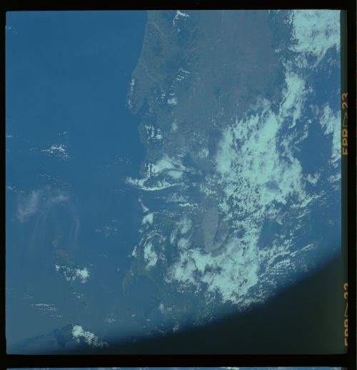
Image Caption:
Northern Luzon
This regional view of northern Luzon shows the drainages likely
to be effected by ash deposits and mud flows following the erup-
tion of Mt. Pinatubo (1). Arrows point to the large rivers.
Note the proximty of the mountain to Manila Bay (2). Laguna de
Bay is at (3), and Taal volcano is at (4). (61A-485-15)
