STS61A-37-25
| NASA Photo ID | STS61A-37-25 |
| Focal Length | 250mm |
| Date taken | 1985.11.01 |
| Time taken | 00:40:34 GMT |

Cloud masks available for this image:
Spacecraft nadir point: 23.4° S, 121.4° E
Photo center point: 22.0° S, 122.5° E
Photo center point by machine learning:
Photo center point: 22.0° S, 122.5° E
Photo center point by machine learning:
Nadir to Photo Center: Northeast
Spacecraft Altitude: 178 nautical miles (330km)
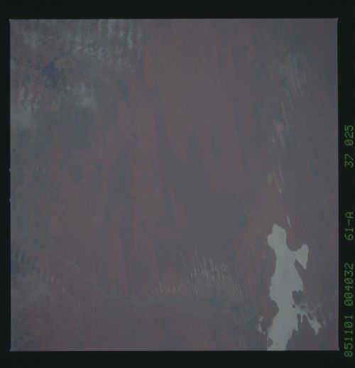
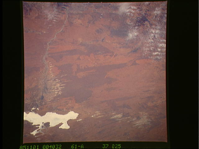
Country or Geographic Name: | AUSTRALIA-WA |
Features: | LAKE DORA |
| Features Found Using Machine Learning: | |
Cloud Cover Percentage: | 5 (1-10)% |
Sun Elevation Angle: | 47° |
Sun Azimuth: | 86° |
Camera: | Hasselblad |
Focal Length: | 250mm |
Camera Tilt: | Near Vertical |
Format: | 5017: Kodak, natural color positive, Ektachrome, X Professional, ASA 64, standard base |
Film Exposure: | Normal |
| Additional Information | |
| Width | Height | Annotated | Cropped | Purpose | Links |
|---|---|---|---|---|---|
| 5700 pixels | 5900 pixels | No | No | Download Image | |
| 500 pixels | 518 pixels | No | No | Download Image | |
| 640 pixels | 480 pixels | No | No | Download Image |
Download Packaged File
Download a Google Earth KML for this Image
View photo footprint information
Download a GeoTIFF for this photo
Image Caption: Apart from the linear, E-W dune ridges (bottom, center), one of
the major patterns visible in the semi-arid subtropics is that of
burn scars, show well here. The Rudall River occasionally brings
water to Lake Dora. White muds and salt crusts can be seen in
the swales between the dunes where flood waters have spilled into
the dunes. (61A-37-25)
the major patterns visible in the semi-arid subtropics is that of
burn scars, show well here. The Rudall River occasionally brings
water to Lake Dora. White muds and salt crusts can be seen in
the swales between the dunes where flood waters have spilled into
the dunes. (61A-37-25)
