STS51F-42-34
| NASA Photo ID | STS51F-42-34 |
| Focal Length | 100mm |
| Date taken | 1985.08.03 |
| Time taken | 22:02:15 GMT |
Resolutions offered for this image:
3904 x 3936 pixels 634 x 639 pixels 5700 x 6000 pixels 500 x 526 pixels 640 x 480 pixels 2540 x 2487 pixels 2513 x 2514 pixels 3872 x 3904 pixels
3904 x 3936 pixels 634 x 639 pixels 5700 x 6000 pixels 500 x 526 pixels 640 x 480 pixels 2540 x 2487 pixels 2513 x 2514 pixels 3872 x 3904 pixels


Cloud masks available for this image:
Spacecraft nadir point: 36.0° N, 116.7° W
Photo center point: 36.0° N, 119.0° W
Photo center point by machine learning:
Photo center point: 36.0° N, 119.0° W
Photo center point by machine learning:
Nadir to Photo Center: West
Spacecraft Altitude: 173 nautical miles (320km)
Country or Geographic Name: | USA-CALIFORNIA |
Features: | BAKERSFIELD, OWENS LAKE |
| Features Found Using Machine Learning: | |
Cloud Cover Percentage: | 0 (no clouds present) |
Sun Elevation Angle: | 55° |
Sun Azimuth: | 245° |
Camera: | Hasselblad |
Focal Length: | 100mm |
Camera Tilt: | 39 degrees |
Format: | 5017: Kodak, natural color positive, Ektachrome, X Professional, ASA 64, standard base |
Film Exposure: | Normal |
| Additional Information | |
| Width | Height | Annotated | Cropped | Purpose | Links |
|---|---|---|---|---|---|
| 3904 pixels | 3936 pixels | No | No | Earth From Space collection | Download Image |
| 634 pixels | 639 pixels | No | No | Earth From Space collection | Download Image |
| 5700 pixels | 6000 pixels | No | No | Download Image | |
| 500 pixels | 526 pixels | No | No | Download Image | |
| 640 pixels | 480 pixels | No | No | Download Image | |
| 2540 pixels | 2487 pixels | Download Image | |||
| 2513 pixels | 2514 pixels | Download Image | |||
| 3872 pixels | 3904 pixels | Download Image |
Download Packaged File
Download a Google Earth KML for this Image
View photo footprint information
Download a GeoTIFF for this photo
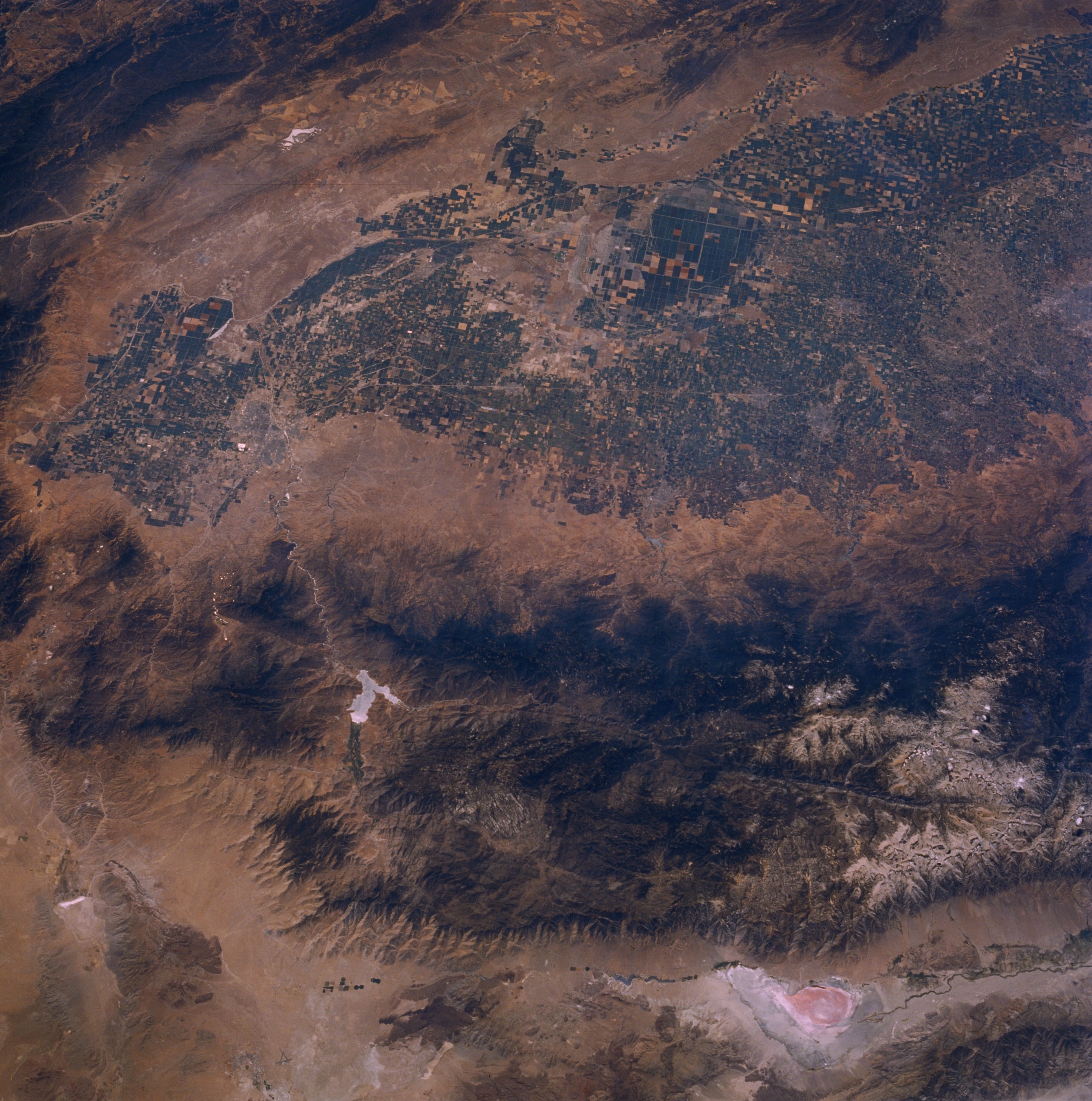
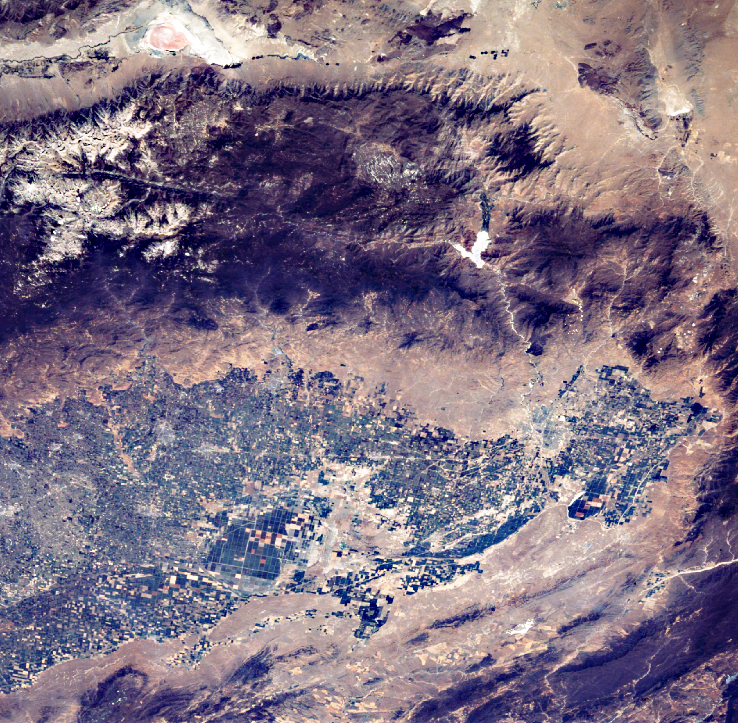
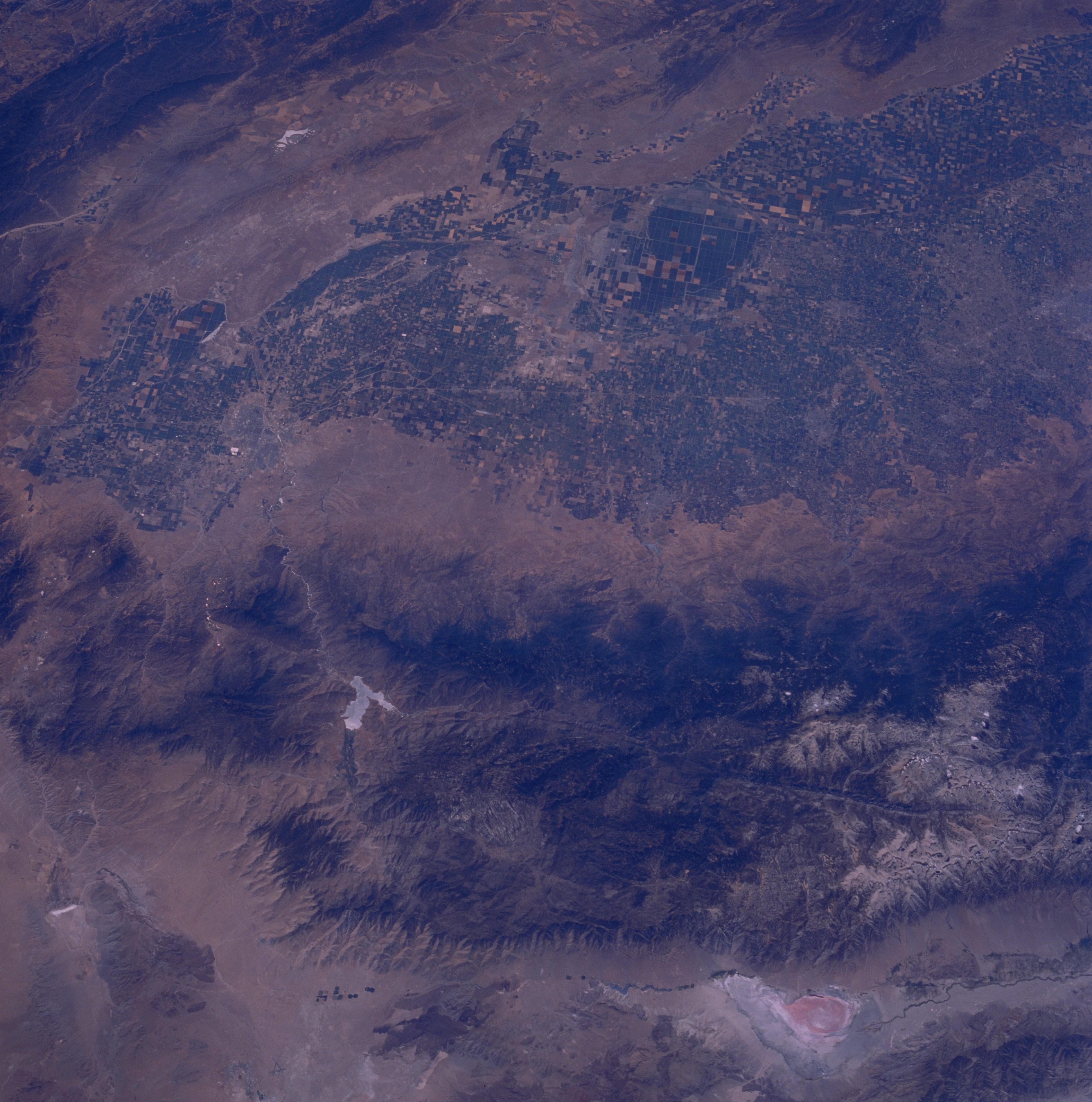
Image Caption: STS51F-042-0034 Sierra Nevada Mountains and San Joaquin Valley, California, U.S.A. August 1985
This photograph encompasses the Sierra Nevada Mountains, reddish Owens Lake, the southern San Joaquin Valley, and the faulted Owens River Valley. Traversing the Sierra Nevada Mountains westward from Owens Lake is the north-south-trending Kern River Valley. This deep valley can be traced from its source near snowcapped Mount Whitney [highest peak in the 48 contiguous states at 14 491 feet (4417 meters)] to Lake Isabella (Y-shaped reservoir with a highly reflective surface) and then southwest to Bakersfield. Immediately west of the forested Sierra Nevada Mountains is the broad expanse of the southern intensively agricultural San Joaquin Valley. Discernible are the vague outline of Bakersfield, several smaller rural cities, and the low mountains and hills to the west and southwest that eventually grade into the Coast Range.
This photograph encompasses the Sierra Nevada Mountains, reddish Owens Lake, the southern San Joaquin Valley, and the faulted Owens River Valley. Traversing the Sierra Nevada Mountains westward from Owens Lake is the north-south-trending Kern River Valley. This deep valley can be traced from its source near snowcapped Mount Whitney [highest peak in the 48 contiguous states at 14 491 feet (4417 meters)] to Lake Isabella (Y-shaped reservoir with a highly reflective surface) and then southwest to Bakersfield. Immediately west of the forested Sierra Nevada Mountains is the broad expanse of the southern intensively agricultural San Joaquin Valley. Discernible are the vague outline of Bakersfield, several smaller rural cities, and the low mountains and hills to the west and southwest that eventually grade into the Coast Range.
