STS51F-35-29
| NASA Photo ID | STS51F-35-29 |
| Focal Length | 250mm |
| Date taken | 1985.08.04 |
| Time taken | 05:48:04 GMT |


Cloud masks available for this image:
Spacecraft nadir point: 48.8° N, 170.1° W
Photo center point:
Photo center point by machine learning:
Photo center point:
Photo center point by machine learning:
Nadir to Photo Center:
Spacecraft Altitude: 178 nautical miles (330km)
Country or Geographic Name: | USA-ALASKA |
Features: | ALEUTIAN ISLANDS |
| Features Found Using Machine Learning: | |
Cloud Cover Percentage: | 90 (76-100)% |
Sun Elevation Angle: | 9° |
Sun Azimuth: | 285° |
Camera: | Hasselblad |
Focal Length: | 250mm |
Camera Tilt: | Low Oblique |
Format: | 5017: Kodak, natural color positive, Ektachrome, X Professional, ASA 64, standard base |
Film Exposure: | Normal |
| Additional Information | |
| Width | Height | Annotated | Cropped | Purpose | Links |
|---|---|---|---|---|---|
| 5700 pixels | 5900 pixels | No | No | Download Image | |
| 500 pixels | 518 pixels | No | No | Download Image | |
| 640 pixels | 480 pixels | No | No | Download Image |
Download Packaged File
Download a Google Earth KML for this Image
View photo footprint information
Download a GeoTIFF for this photo
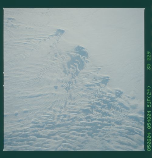
Image Caption: Cloud Wakes around the Aleutian Is.
Here we see how surface topography influences cloud
structure. As the clouds, moving in the direction of the wind, reach
the peaks of the Aleutian Is. chain they take the form of a
wake leeward of the islands. It looks as though the islands
are moving through the clouds like a ship in the water.
Here we see how surface topography influences cloud
structure. As the clouds, moving in the direction of the wind, reach
the peaks of the Aleutian Is. chain they take the form of a
wake leeward of the islands. It looks as though the islands
are moving through the clouds like a ship in the water.
