STS51B-53-11
| NASA Photo ID | STS51B-53-11 |
| Focal Length | 250mm |
| Date taken | 1985.__.__ |
| Time taken | GMT |
Resolutions offered for this image:
3904 x 3875 pixels 639 x 635 pixels 5700 x 5900 pixels 7334 x 7277 pixels 500 x 518 pixels 691 x 757 pixels
3904 x 3875 pixels 639 x 635 pixels 5700 x 5900 pixels 7334 x 7277 pixels 500 x 518 pixels 691 x 757 pixels


Cloud masks available for this image:
Spacecraft nadir point:
Photo center point: 29.5° N, 91.5° W
Photo center point by machine learning:
Photo center point: 29.5° N, 91.5° W
Photo center point by machine learning:
Nadir to Photo Center:
Spacecraft Altitude: nautical miles (0km)
Country or Geographic Name: | USA-LOUISIANA |
Features: | ATCHAFALAYA BAY |
| Features Found Using Machine Learning: | |
Cloud Cover Percentage: | 0 (no clouds present) |
Sun Elevation Angle: | ° |
Sun Azimuth: | ° |
Camera: | Hasselblad |
Focal Length: | 250mm |
Camera Tilt: | Near Vertical |
Format: | 5017: Kodak, natural color positive, Ektachrome, X Professional, ASA 64, standard base |
Film Exposure: | Normal |
| Additional Information | |
| Width | Height | Annotated | Cropped | Purpose | Links |
|---|---|---|---|---|---|
| 3904 pixels | 3875 pixels | No | No | Earth From Space collection | Download Image |
| 639 pixels | 635 pixels | No | No | Earth From Space collection | Download Image |
| 5700 pixels | 5900 pixels | No | No | Download Image | |
| 7334 pixels | 7277 pixels | No | No | Scientist Request | Download Image |
| 500 pixels | 518 pixels | No | No | Download Image | |
| 691 pixels | 757 pixels | Yes | No | Download Image |
Download Packaged File
Download a Google Earth KML for this Image
View photo footprint information
Download a GeoTIFF for this photo
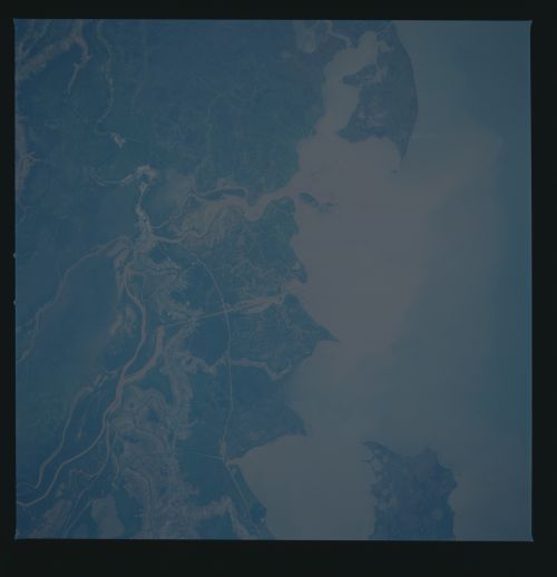
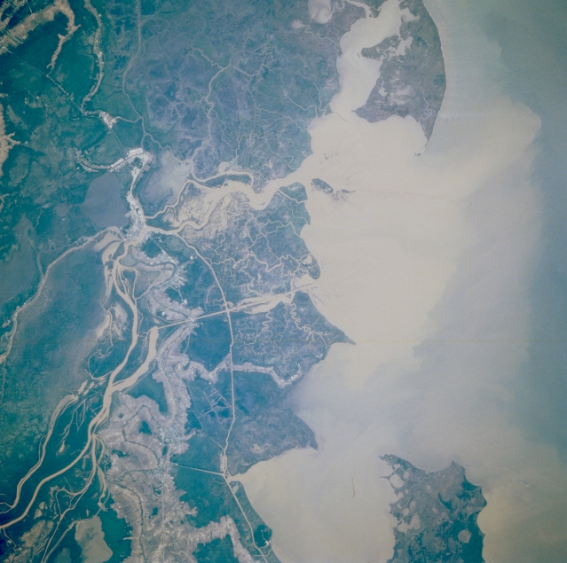
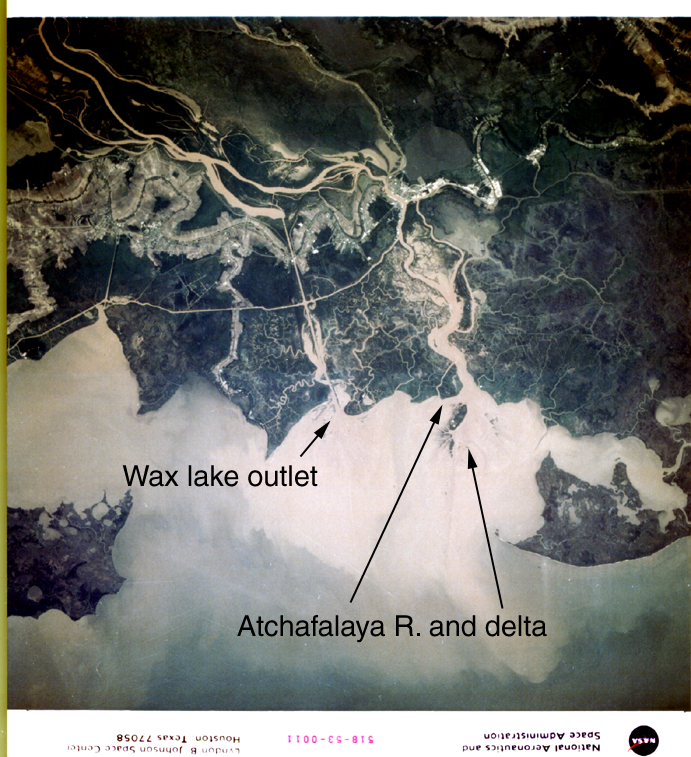
Image Caption: STS51B-053-0011 Atchafalaya River Delta, Louisiana, U.S.A. May 1985
The Atchafalaya River, showing an enormous sediment plume, is the main distributary of the Mississippi River and, as such, diverts large quantities of water from the Mississippi River to Atchafalaya Bay through the Atchafalaya drainage basin. The Atchafalaya's muddy delta at its mouth is the result of massive quantities of sediment being transported and deposited into the bay. Most of the Louisiana coastline is being diminished by the loss of wetlands; however, this part of the coastline is enlarging with wetlands encompassing cypress swamps, marshes, bayous, lakes, natural levees, and numerous distributaries of the Atchafalaya River. Visible is the thin Intracoastal Waterway that roughly parallels the coast.
The Atchafalaya River, showing an enormous sediment plume, is the main distributary of the Mississippi River and, as such, diverts large quantities of water from the Mississippi River to Atchafalaya Bay through the Atchafalaya drainage basin. The Atchafalaya's muddy delta at its mouth is the result of massive quantities of sediment being transported and deposited into the bay. Most of the Louisiana coastline is being diminished by the loss of wetlands; however, this part of the coastline is enlarging with wetlands encompassing cypress swamps, marshes, bayous, lakes, natural levees, and numerous distributaries of the Atchafalaya River. Visible is the thin Intracoastal Waterway that roughly parallels the coast.
