STS51B-35-94
| NASA Photo ID | STS51B-35-94 |
| Focal Length | 100mm |
| Date taken | 1985.05.01 |
| Time taken | 18:28:57 GMT |

Cloud masks available for this image:
Spacecraft nadir point: 31.8° N, 124.3° W
Photo center point: 28.5° N, 118.5° W
Photo center point by machine learning:
Photo center point: 28.5° N, 118.5° W
Photo center point by machine learning:
Nadir to Photo Center: Southeast
Spacecraft Altitude: 192 nautical miles (356km)
Country or Geographic Name: | MEXICO |
Features: | ISLA DE GUADALUPE |
| Features Found Using Machine Learning: | |
Cloud Cover Percentage: | 70 (51-75)% |
Sun Elevation Angle: | 60° |
Sun Azimuth: | 118° |
Camera: | Hasselblad |
Focal Length: | 100mm |
Camera Tilt: | High Oblique |
Format: | 5017: Kodak, natural color positive, Ektachrome, X Professional, ASA 64, standard base |
Film Exposure: | Normal |
| Additional Information | |
| Width | Height | Annotated | Cropped | Purpose | Links |
|---|---|---|---|---|---|
| 5700 pixels | 5900 pixels | No | No | Download Image | |
| 500 pixels | 518 pixels | No | No | Download Image |
Download Packaged File
Download a Google Earth KML for this Image
View photo footprint information
Download a GeoTIFF for this photo
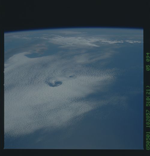
Image Caption: Von Karmen Vortices off Guadeloupe Is.
Seeing certain weather features tells us information as to
what the conditions were at the time the photo was taken.
For instance, formation of these Von Karman vortices
requires windspeeds of 5 and 13 meters per second and a
strong low level temperature inversion. If the winds were
higher the vortices would be pulled apart.
