STS51B-34-80

| NASA Photo ID | STS51B-34-80 |
| Focal Length | 250mm |
| Date taken | 1985.__.__ |
| Time taken | GMT |
Resolutions offered for this image:
5275 x 5222 pixels 639 x 633 pixels 5700 x 5900 pixels 500 x 518 pixels
5275 x 5222 pixels 639 x 633 pixels 5700 x 5900 pixels 500 x 518 pixels
Cloud masks available for this image:
Spacecraft nadir point:
Photo center point: 19.0° N, 98.5° W
Photo center point by machine learning:
Photo center point: 19.0° N, 98.5° W
Photo center point by machine learning:
Nadir to Photo Center:
Spacecraft Altitude: nautical miles (0km)
Country or Geographic Name: | MEXICO |
Features: | POPOCATEPETL, PUEBLA |
| Features Found Using Machine Learning: | |
Cloud Cover Percentage: | 2 (1-10)% |
Sun Elevation Angle: | ° |
Sun Azimuth: | ° |
Camera: | Hasselblad |
Focal Length: | 250mm |
Camera Tilt: | Near Vertical |
Format: | 5017: Kodak, natural color positive, Ektachrome, X Professional, ASA 64, standard base |
Film Exposure: | Normal |
| Additional Information | |
| Width | Height | Annotated | Cropped | Purpose | Links |
|---|---|---|---|---|---|
| 5275 pixels | 5222 pixels | No | No | Earth From Space collection | Download Image |
| 639 pixels | 633 pixels | No | No | Earth From Space collection | Download Image |
| 5700 pixels | 5900 pixels | No | No | Download Image | |
| 500 pixels | 518 pixels | No | No | Download Image |
Download Packaged File
Download a Google Earth KML for this Image
View photo footprint information
Download a GeoTIFF for this photo
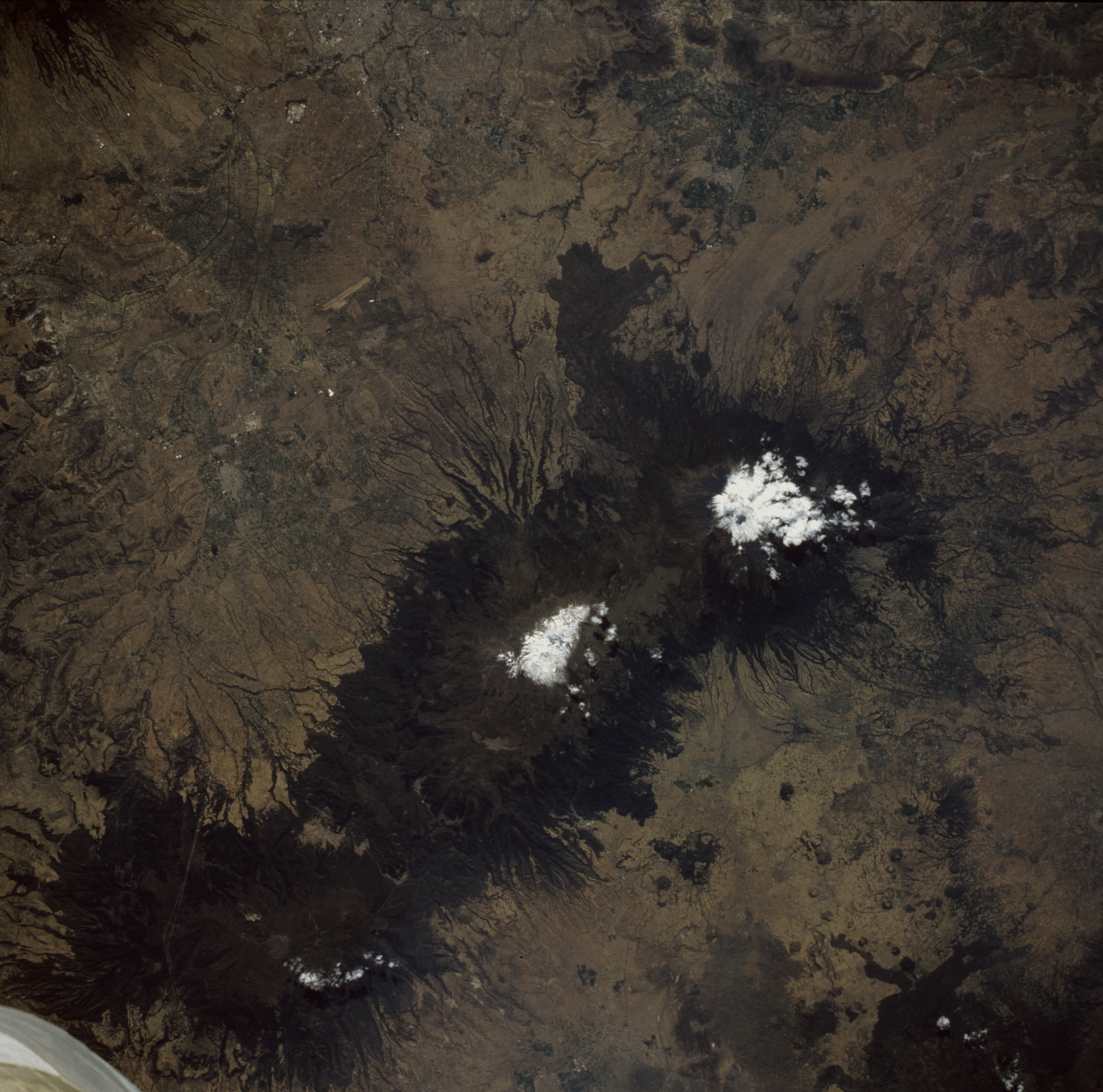
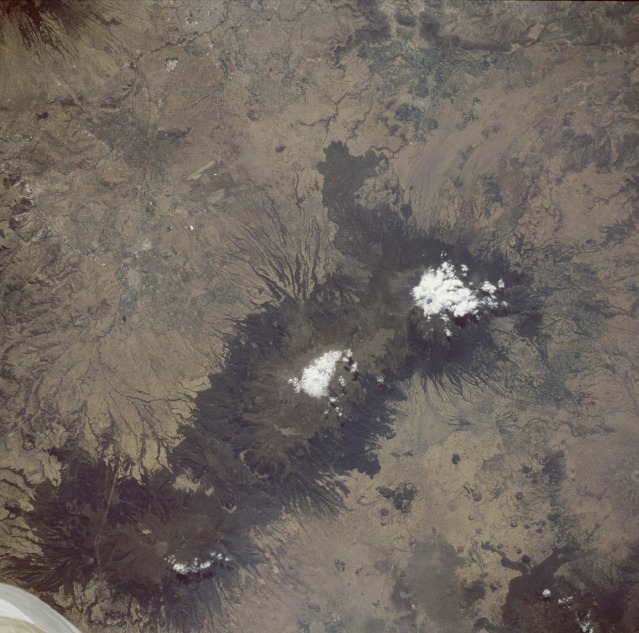
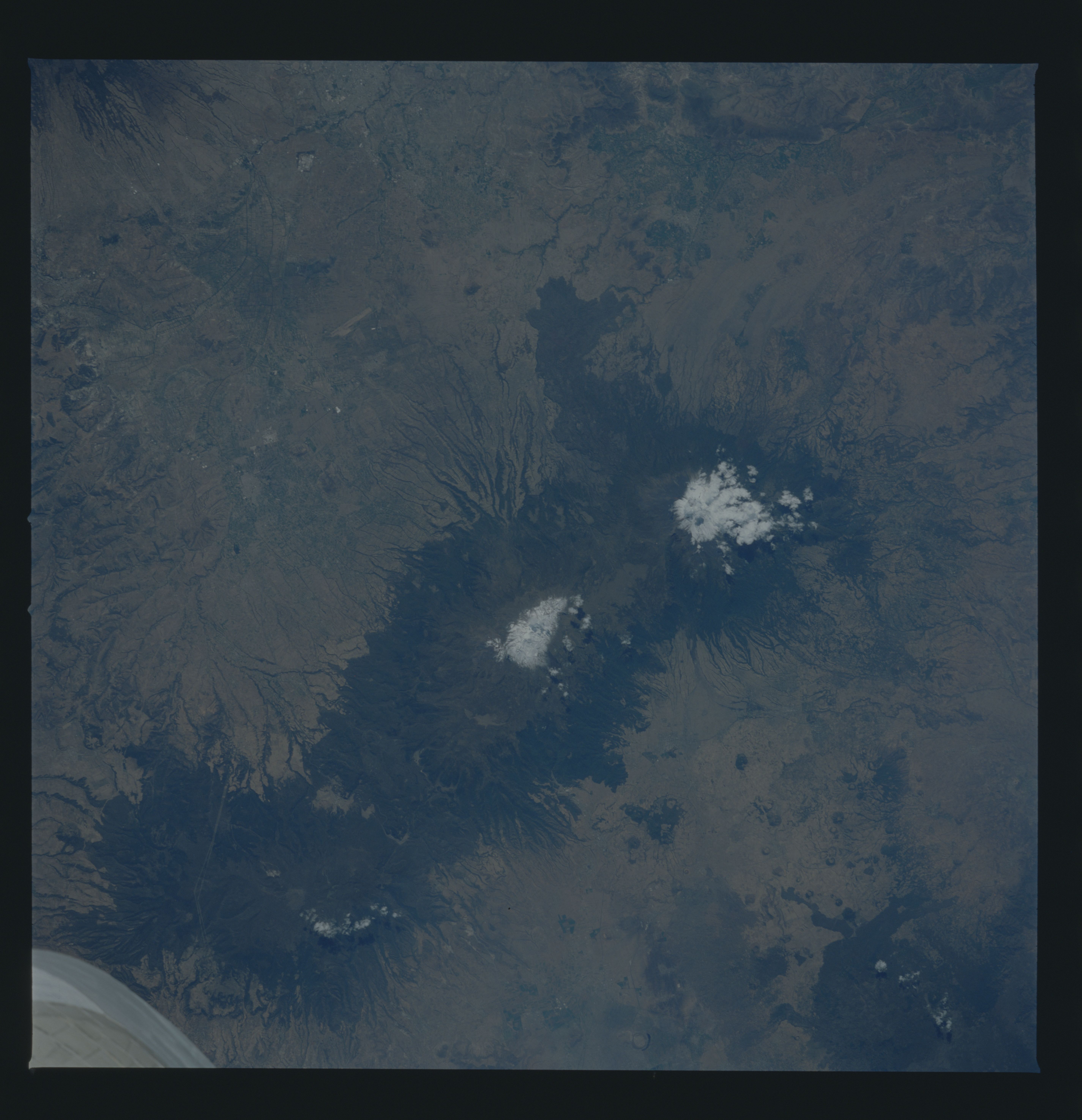
Image Caption: STS51B-034-0080 Popocatepetl and Ixtaccihuatl Volcanoes, Mexico April 1985
Three individual volcanoes, aligned in a general north-south direction and located about 45 miles (72 kilometers) southeast of Mexico City on the Mexican Plateau, are clearly visible in this near-vertical photograph. The classic radial erosion drainage pattern associated with most stratovolcanoes is very evident around the flanks of all these volcanoes. Upon close inspection, numerous cinder cones can be seen, especially on the plains west of the volcanoes. Two of the volcanoes, Ixtaccihuatl [17 343 feet (5285 meters)] and Popocatepetl [17 887 feet (5452 meters)] have snow-covered summits. Clouds partially obscure Popocatepetl's large oval crater that measures approximately 2000 feet (600 meters) in diameter and more than 500 feet (150 meters) in depth. Southernmost Popocatepetl is the most famous volcano in Mexico. Its name was derived from an ancient Aztec word meaning "the smoking mountain." Eruptions of the volcano in the mid 1990s put Mexico City and the surrounding communities on alert. The last known eruptions of Popocatepetl before the mid 1990s occurred in the 17th century. The linear feature east of volcano appears to be an airport runway.
Three individual volcanoes, aligned in a general north-south direction and located about 45 miles (72 kilometers) southeast of Mexico City on the Mexican Plateau, are clearly visible in this near-vertical photograph. The classic radial erosion drainage pattern associated with most stratovolcanoes is very evident around the flanks of all these volcanoes. Upon close inspection, numerous cinder cones can be seen, especially on the plains west of the volcanoes. Two of the volcanoes, Ixtaccihuatl [17 343 feet (5285 meters)] and Popocatepetl [17 887 feet (5452 meters)] have snow-covered summits. Clouds partially obscure Popocatepetl's large oval crater that measures approximately 2000 feet (600 meters) in diameter and more than 500 feet (150 meters) in depth. Southernmost Popocatepetl is the most famous volcano in Mexico. Its name was derived from an ancient Aztec word meaning "the smoking mountain." Eruptions of the volcano in the mid 1990s put Mexico City and the surrounding communities on alert. The last known eruptions of Popocatepetl before the mid 1990s occurred in the 17th century. The linear feature east of volcano appears to be an airport runway.
