STS51B-33-31
| NASA Photo ID | STS51B-33-31 |
| Focal Length | 100mm |
| Date taken | 1985.__.__ |
| Time taken | GMT |
Resolutions offered for this image:
3904 x 3904 pixels 639 x 639 pixels 5700 x 5900 pixels 500 x 518 pixels
3904 x 3904 pixels 639 x 639 pixels 5700 x 5900 pixels 500 x 518 pixels

Cloud masks available for this image:
Spacecraft nadir point:
Photo center point: 44.0° N, 75.5° W
Photo center point by machine learning:
Photo center point: 44.0° N, 75.5° W
Photo center point by machine learning:
Nadir to Photo Center:
Spacecraft Altitude: nautical miles (0km)
Country or Geographic Name: | USA-NEW YORK |
Features: | ST. LAWRENCE RIVER |
| Features Found Using Machine Learning: | |
Cloud Cover Percentage: | 0 (no clouds present) |
Sun Elevation Angle: | ° |
Sun Azimuth: | ° |
Camera: | Hasselblad |
Focal Length: | 100mm |
Camera Tilt: | Near Vertical |
Format: | 5017: Kodak, natural color positive, Ektachrome, X Professional, ASA 64, standard base |
Film Exposure: | Normal |
| Additional Information | |
| Width | Height | Annotated | Cropped | Purpose | Links |
|---|---|---|---|---|---|
| 3904 pixels | 3904 pixels | No | No | Earth From Space collection | Download Image |
| 639 pixels | 639 pixels | No | No | Earth From Space collection | Download Image |
| 5700 pixels | 5900 pixels | No | No | Download Image | |
| 500 pixels | 518 pixels | No | No | Download Image |
Download Packaged File
Download a Google Earth KML for this Image
View photo footprint information
Download a GeoTIFF for this photo
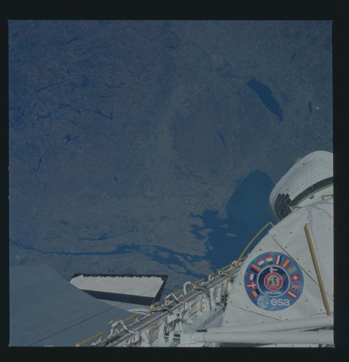
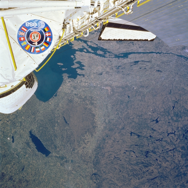
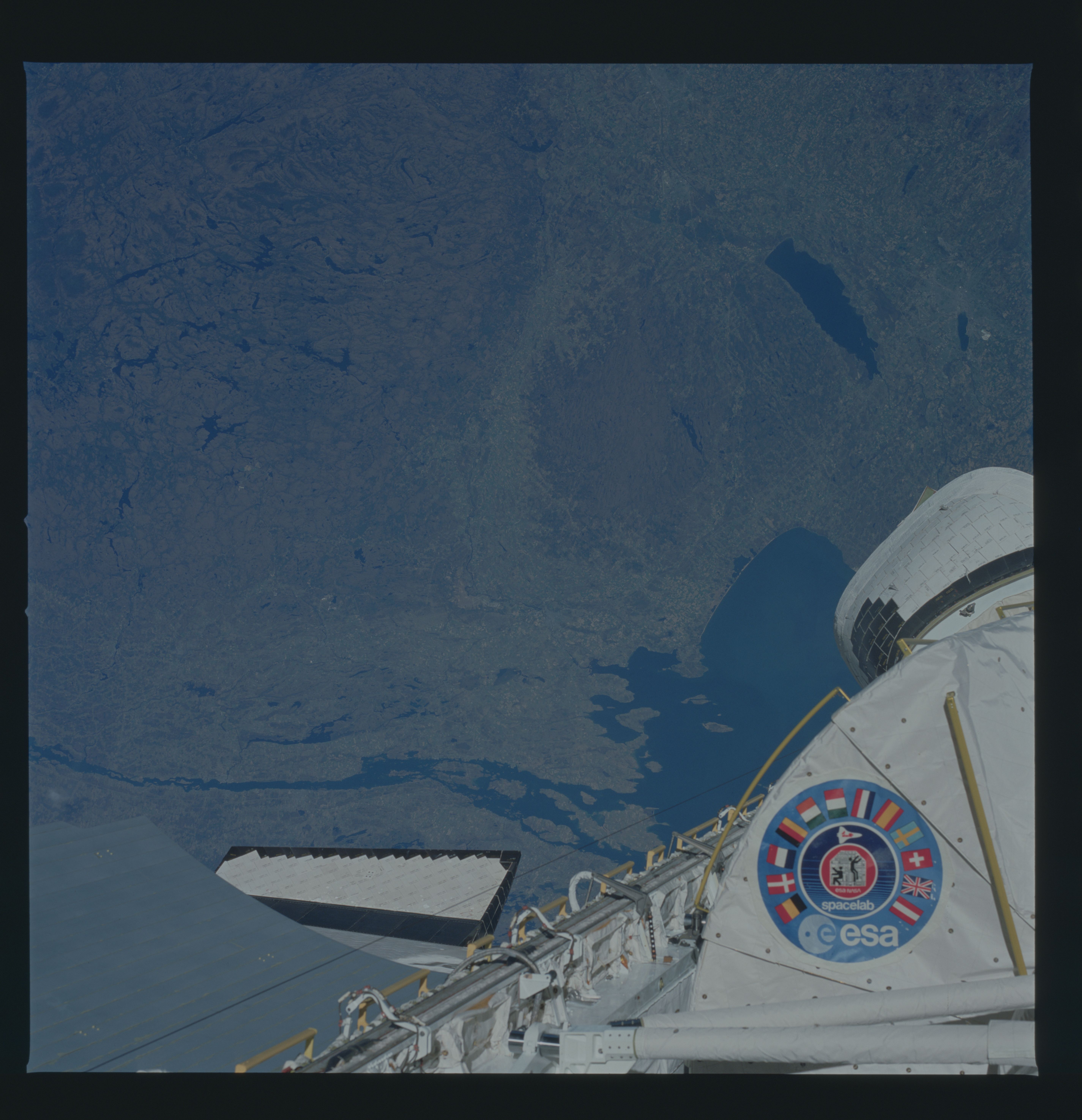
Image Caption: STS51B-33-0031 Oneida Lake, Tug Hill Plateau, Adirondacks, New York May 1985
The varied landscape of north-central New York can be seen in this northwest-looking view. The Space Shuttle covers the upper portion of this image. The Saint Lawrence River, with Lake Ontario to the west (left) is visible traversing the upper portion of the image. Oneida Lake, an arm of the former pre-glacial Lake Iroquois, is a shallow lake 22 miles (35 km) long and about 6 miles (10 km) wide. Lake Onieda is part of the New York Barge Canal System (former Erie Canal) and is visible in the lower left quadrant of the image. To the southwest (left) of Oneida Lake is the city of Syracuse with Onandaga Lake situated in the city's northwest sector. To the north and east of Oneida Lake is the barren and rugged Tug Hill Plateau. The Tug Hill Plateau is an outlying remnant of the Allegheny Plateau to the south. With the plateau's location east of Lake Ontario, the Tug Hill Plateau receives some of the highest yearly snowfall amounts of anywhere in the eastern United States. The Black River Valley separates the Tug Hill Plateau from the rugged, forested Adirondack Mountains (lower right). A circular mountain mass, the Adirondacks area is a southern extension of the Laurentian Plateau of eastern Canada. Composed chiefly of Metamorphic rock, the rising mountain mass is like a large dome that has been eroded by streams and carved by glaciers for over thousands of years, giving the Adirondacks its rugged appearance.
The varied landscape of north-central New York can be seen in this northwest-looking view. The Space Shuttle covers the upper portion of this image. The Saint Lawrence River, with Lake Ontario to the west (left) is visible traversing the upper portion of the image. Oneida Lake, an arm of the former pre-glacial Lake Iroquois, is a shallow lake 22 miles (35 km) long and about 6 miles (10 km) wide. Lake Onieda is part of the New York Barge Canal System (former Erie Canal) and is visible in the lower left quadrant of the image. To the southwest (left) of Oneida Lake is the city of Syracuse with Onandaga Lake situated in the city's northwest sector. To the north and east of Oneida Lake is the barren and rugged Tug Hill Plateau. The Tug Hill Plateau is an outlying remnant of the Allegheny Plateau to the south. With the plateau's location east of Lake Ontario, the Tug Hill Plateau receives some of the highest yearly snowfall amounts of anywhere in the eastern United States. The Black River Valley separates the Tug Hill Plateau from the rugged, forested Adirondack Mountains (lower right). A circular mountain mass, the Adirondacks area is a southern extension of the Laurentian Plateau of eastern Canada. Composed chiefly of Metamorphic rock, the rising mountain mass is like a large dome that has been eroded by streams and carved by glaciers for over thousands of years, giving the Adirondacks its rugged appearance.
