STS51B-146-118
| NASA Photo ID | STS51B-146-118 |
| Focal Length | 250mm |
| Date taken | 1985.__.__ |
| Time taken | GMT |


Cloud masks available for this image:
Spacecraft nadir point:
Photo center point: 40.7° N, 113.6° W
Photo center point by machine learning:
Photo center point: 40.7° N, 113.6° W
Photo center point by machine learning:
Nadir to Photo Center:
Spacecraft Altitude: nautical miles (0km)
Country or Geographic Name: | USA-UTAH |
Features: | GREAT SALT LAKE DESERT |
| Features Found Using Machine Learning: | |
Cloud Cover Percentage: | 0 (no clouds present) |
Sun Elevation Angle: | ° |
Sun Azimuth: | ° |
Camera: | Linhof |
Focal Length: | 250mm |
Camera Tilt: | Low Oblique |
Format: | 5017: Kodak, natural color positive, Ektachrome, X Professional, ASA 64, standard base |
Film Exposure: | Normal |
| Additional Information | |
| Width | Height | Annotated | Cropped | Purpose | Links |
|---|---|---|---|---|---|
| 5184 pixels | 4096 pixels | No | No | Earth From Space collection | Download Image |
| 640 pixels | 505 pixels | No | No | Earth From Space collection | Download Image |
| 640 pixels | 480 pixels | No | No | ISD 1 | Download Image |
Download Packaged File
Download a Google Earth KML for this Image
View photo footprint information
Download a GeoTIFF for this photo
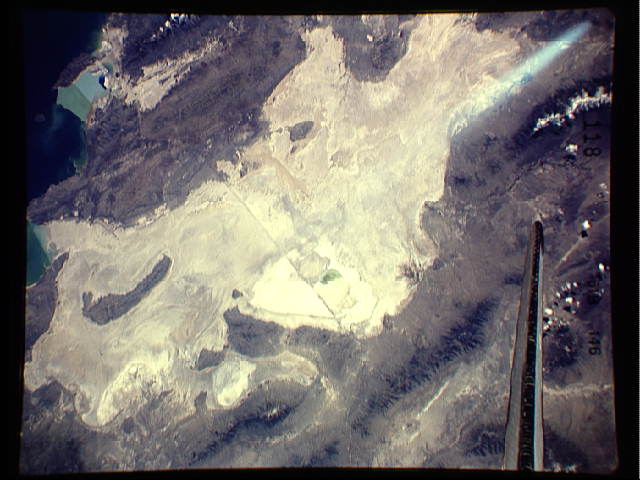
Image Caption: STS51B-146-0118 Great Salt Lake Desert, Utah and Nevada, U.S.A. May 1985
The dry, salt-encrusted bed of prehistoric Lake Bonneville is apparent in this south-southeast-looking, low-oblique photograph. The Great Salt Lake Desert is a small remnant of the prehistoric lake that covered portions of present-day Idaho, Nevada, and Utah during the last ice age 12 000 years ago. Parts of the Great Salt Lake Desert are sometimes covered with shallow ponds as a result of above-normal precipitation. When these small ponds dry up, the thick, salt-encrusted desert floor is increased. The extreme western portion of Great Salt Lake is visible in the upper left of the photograph.
The dry, salt-encrusted bed of prehistoric Lake Bonneville is apparent in this south-southeast-looking, low-oblique photograph. The Great Salt Lake Desert is a small remnant of the prehistoric lake that covered portions of present-day Idaho, Nevada, and Utah during the last ice age 12 000 years ago. Parts of the Great Salt Lake Desert are sometimes covered with shallow ponds as a result of above-normal precipitation. When these small ponds dry up, the thick, salt-encrusted desert floor is increased. The extreme western portion of Great Salt Lake is visible in the upper left of the photograph.
