STS105-714-28
| NASA Photo ID | STS105-714-28 |
| Focal Length | 50mm |
| Date taken | 2001.08.20 |
| Time taken | GMT |
Resolutions offered for this image:
1029 x 1024 pixels 2063 x 2048 pixels 4127 x 4096 pixels 515 x 512 pixels 4000 x 4000 pixels 639 x 639 pixels 1245 x 1177 pixels 400 x 400 pixels
1029 x 1024 pixels 2063 x 2048 pixels 4127 x 4096 pixels 515 x 512 pixels 4000 x 4000 pixels 639 x 639 pixels 1245 x 1177 pixels 400 x 400 pixels


Cloud masks available for this image:
Spacecraft nadir point:
Photo center point: 40.5° N, 88.0° W
Photo center point by machine learning:
Photo center point: 40.5° N, 88.0° W
Photo center point by machine learning:
Nadir to Photo Center:
Spacecraft Altitude: nautical miles (0km)
Country or Geographic Name: | USA-ILLINOIS |
Features: | PAN-LAKE MICHIGAN |
| Features Found Using Machine Learning: | |
Cloud Cover Percentage: | 75 (51-75)% |
Sun Elevation Angle: | ° |
Sun Azimuth: | ° |
Camera: | Hasselblad |
Focal Length: | 50mm |
Camera Tilt: | |
Format: | 5069: Kodak Elite 100S, E6 Reversal, Replaces Lumiere, Warmer in tone vs. Lumiere |
Film Exposure: | |
| Additional Information | |
| Width | Height | Annotated | Cropped | Purpose | Links |
|---|---|---|---|---|---|
| 1029 pixels | 1024 pixels | No | No | Download Image | |
| 2063 pixels | 2048 pixels | No | No | Download Image | |
| 4127 pixels | 4096 pixels | No | No | Download Image | |
| 515 pixels | 512 pixels | No | No | Download Image | |
| 4000 pixels | 4000 pixels | No | No | Public Affairs Office (PAO) | Download Image |
| 639 pixels | 639 pixels | No | No | Public Affairs Office (PAO) | Download Image |
| 1245 pixels | 1177 pixels | No | No | Download Image | |
| 400 pixels | 400 pixels | No | No | Photographic Highlights | Download Image |
Download Packaged File
Download a Google Earth KML for this Image
View photo footprint information
Download a GeoTIFF for this photo
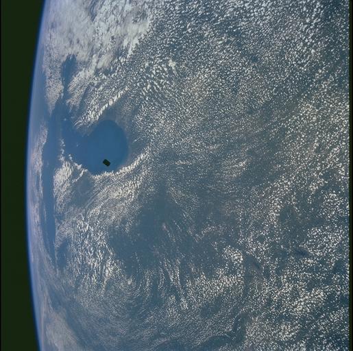
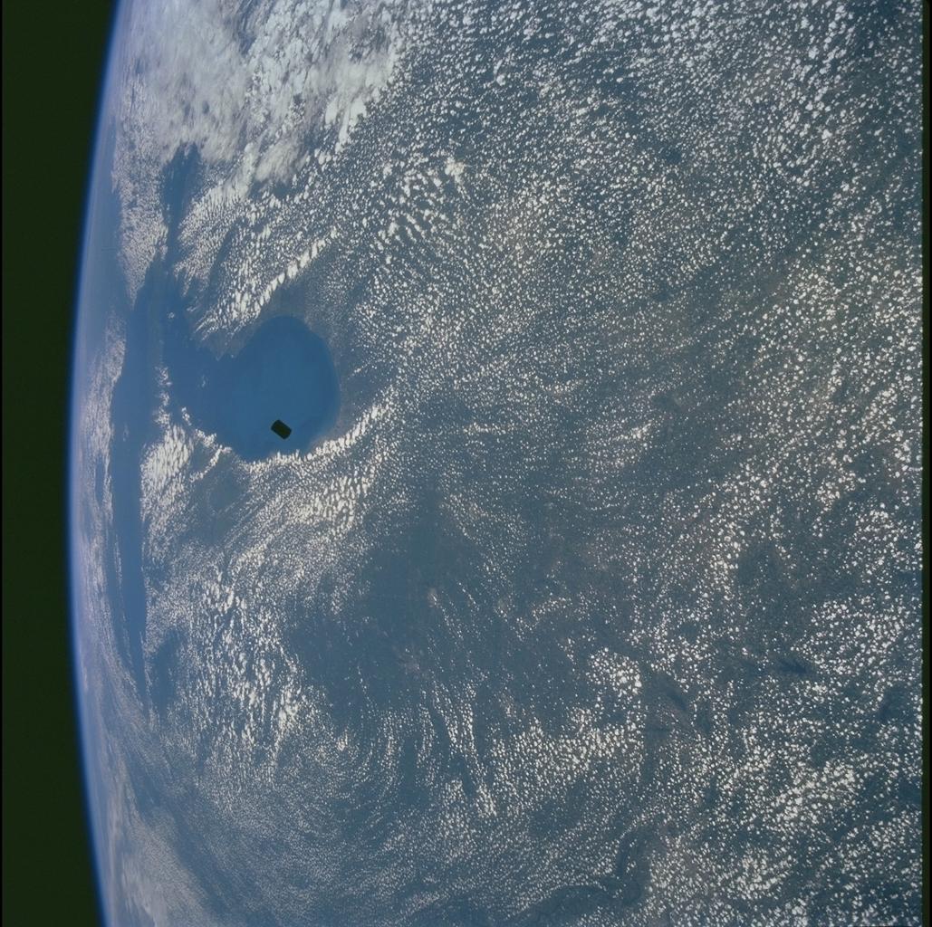
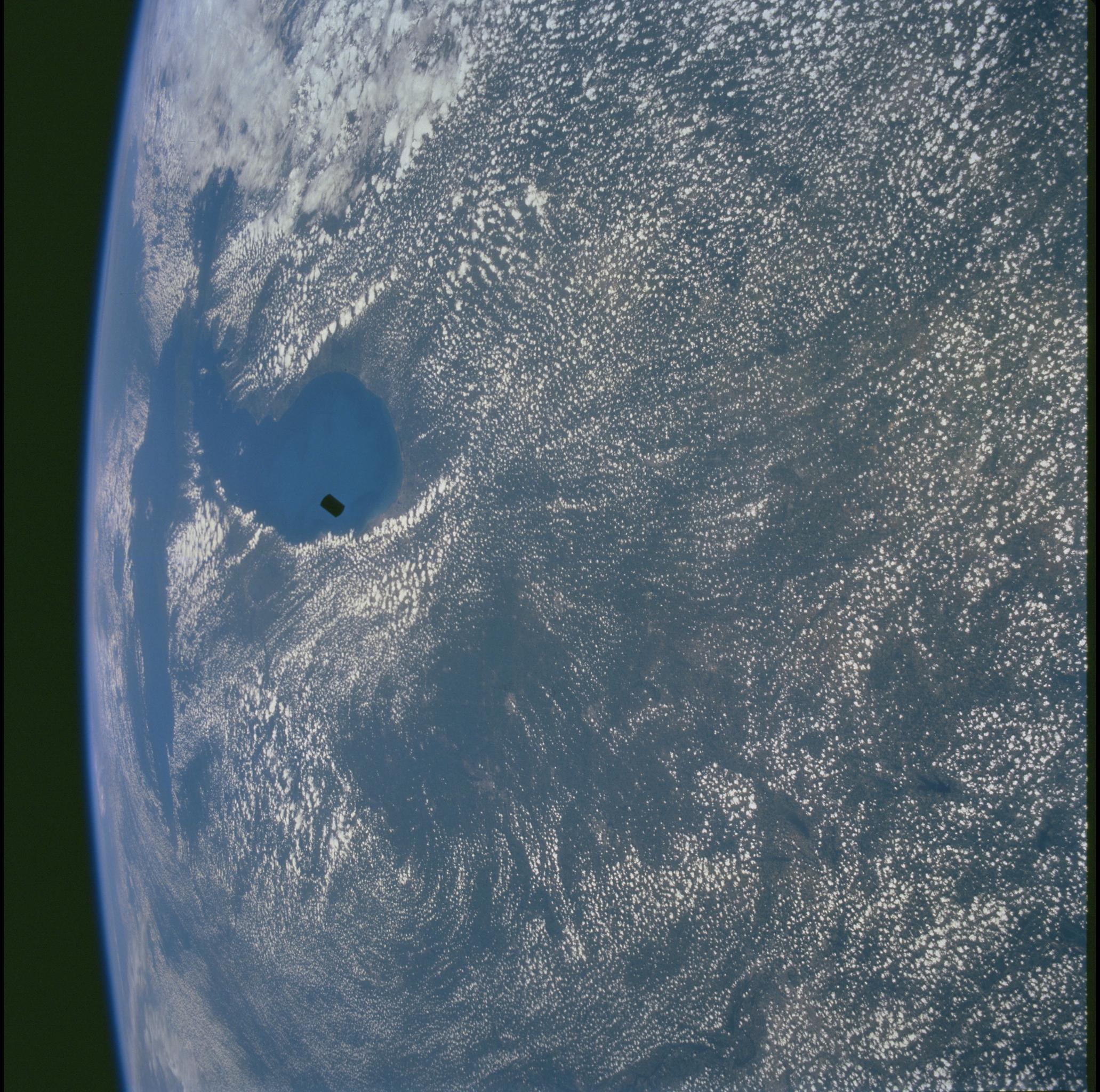
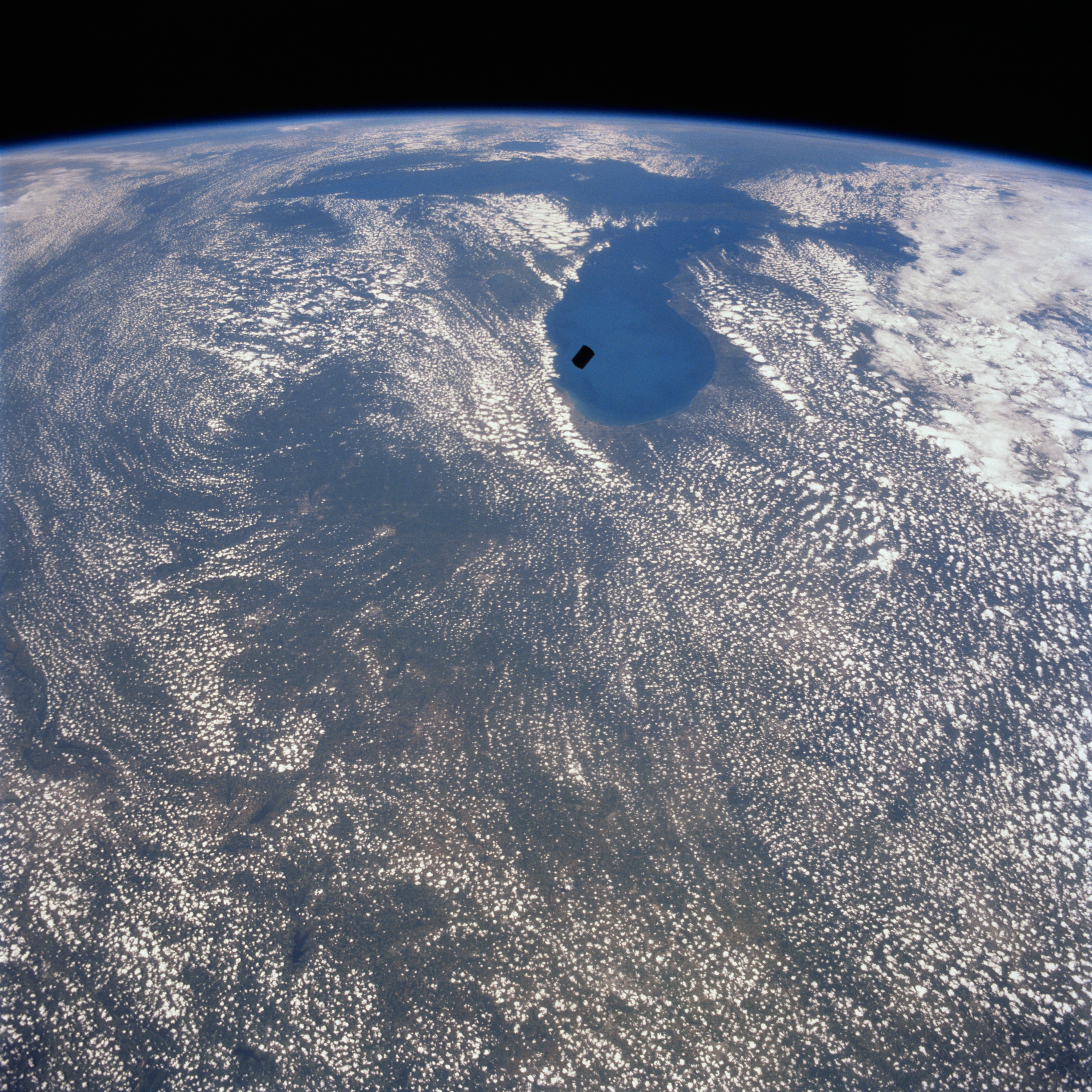
Image Caption: Simplesat over Lake Michigan
With Lake Michigan as a backdrop, this north-looking view shows the recently deployed small sciences satellite called Simplesat (dark rectangular object near the center of the image). Simplesat is an engineering satellite designed to evaluate the use of inexpensive commercial hardware for spacecraft. The satellite was spring-ejected from a canister at the rear of the Shuttle's cargo bay. Lake Michigan is the second deepest and third largest of the five Great Lakes. Lake Michigan is 307 miles (494 km) long and is the only Great Lake wholly within the United States. Cloud free Lake Superior, the largest and deepest of the Great Lakes, is discernible just below the horizon at the top center of the image.
With Lake Michigan as a backdrop, this north-looking view shows the recently deployed small sciences satellite called Simplesat (dark rectangular object near the center of the image). Simplesat is an engineering satellite designed to evaluate the use of inexpensive commercial hardware for spacecraft. The satellite was spring-ejected from a canister at the rear of the Shuttle's cargo bay. Lake Michigan is the second deepest and third largest of the five Great Lakes. Lake Michigan is 307 miles (494 km) long and is the only Great Lake wholly within the United States. Cloud free Lake Superior, the largest and deepest of the Great Lakes, is discernible just below the horizon at the top center of the image.
