STS104-717-96
| NASA Photo ID | STS104-717-96 |
| Focal Length | 350mm |
| Date taken | 2001.07.__ |
| Time taken | GMT |
Resolutions offered for this image:
4049 x 4049 pixels 1031 x 1024 pixels 2063 x 2048 pixels 4127 x 4096 pixels 515 x 512 pixels 640 x 640 pixels 400 x 400 pixels
4049 x 4049 pixels 1031 x 1024 pixels 2063 x 2048 pixels 4127 x 4096 pixels 515 x 512 pixels 640 x 640 pixels 400 x 400 pixels


Cloud masks available for this image:
Spacecraft nadir point:
Photo center point: 15.5° S, 46.5° E
Photo center point by machine learning:
Photo center point: 15.5° S, 46.5° E
Photo center point by machine learning:
Nadir to Photo Center:
Spacecraft Altitude: nautical miles (0km)
Country or Geographic Name: | MADAGASCAR |
Features: | BETSIBOKA ESTUARY |
| Features Found Using Machine Learning: | |
Cloud Cover Percentage: | 10 (1-10)% |
Sun Elevation Angle: | ° |
Sun Azimuth: | ° |
Camera: | Hasselblad |
Focal Length: | 350mm |
Camera Tilt: | |
Format: | 5069: Kodak Elite 100S, E6 Reversal, Replaces Lumiere, Warmer in tone vs. Lumiere |
Film Exposure: | |
| Additional Information | |
| Width | Height | Annotated | Cropped | Purpose | Links |
|---|---|---|---|---|---|
| 4049 pixels | 4049 pixels | No | No | Download Image | |
| 1031 pixels | 1024 pixels | No | No | Download Image | |
| 2063 pixels | 2048 pixels | No | No | Download Image | |
| 4127 pixels | 4096 pixels | No | No | Download Image | |
| 515 pixels | 512 pixels | No | No | Download Image | |
| 640 pixels | 640 pixels | No | No | Public Affairs Office (PAO) | Download Image |
| 400 pixels | 400 pixels | No | No | Photographic Highlights | Download Image |
Download Packaged File
Download a Google Earth KML for this Image
View photo footprint information
Download a GeoTIFF for this photo
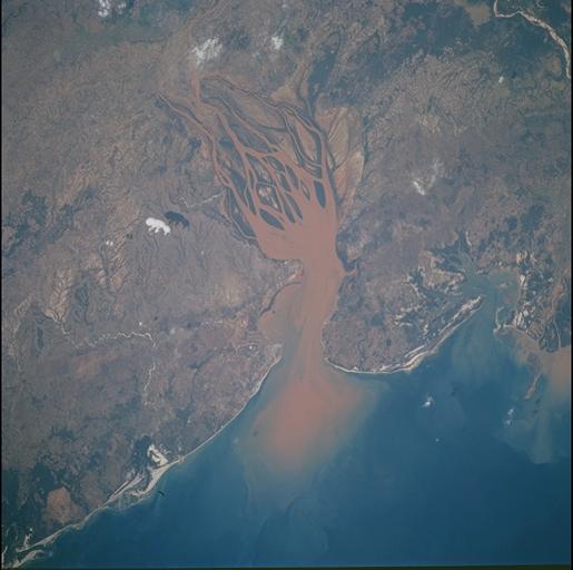
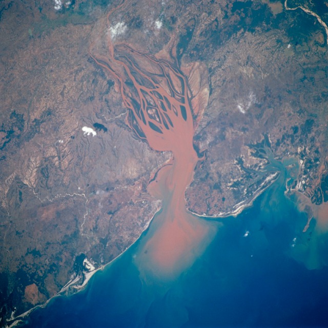
Image Caption: Betsiboka Estuary, Madagascar
During the 20th Century Madagascar, the world's fourth largest island, experienced a tremendous reversal in the quantity of vegetative cover throughout the entire island. From an estimated 80 to 90 percent vegetation cover in 1900 to less than an estimated 10 percent by the year 2000, the rate of deforestation has been dramatic. This image, along with many other space-acquired images, documents the massive annual soil losses that have occurred during the last 30 years. Note the orange-brown sediment that is almost always being transported by the Betsiboka River and being deposited in the delta region. The sequence of images astronauts have taken over time, shows the sediment accumulating and forming islands in the estuary mouth.
During the 20th Century Madagascar, the world's fourth largest island, experienced a tremendous reversal in the quantity of vegetative cover throughout the entire island. From an estimated 80 to 90 percent vegetation cover in 1900 to less than an estimated 10 percent by the year 2000, the rate of deforestation has been dramatic. This image, along with many other space-acquired images, documents the massive annual soil losses that have occurred during the last 30 years. Note the orange-brown sediment that is almost always being transported by the Betsiboka River and being deposited in the delta region. The sequence of images astronauts have taken over time, shows the sediment accumulating and forming islands in the estuary mouth.
