STS102-336-35
| NASA Photo ID | STS102-336-35 |
| Focal Length | mm |
| Date taken | 2001.03.16 |
| Time taken | 15:35:12 GMT |
Cloud masks available for this image:
Spacecraft nadir point: 36.8° N, 69.0° W
Photo center point: 41.0° N, 72.5° W
Photo center point by machine learning:
Photo center point: 41.0° N, 72.5° W
Photo center point by machine learning:
Nadir to Photo Center: Northwest
Spacecraft Altitude: 203 nautical miles (376km)
Country or Geographic Name: | USA-NEW YORK |
Features: | LONG ISLAND, COAST |
| Features Found Using Machine Learning: | |
Cloud Cover Percentage: | 10 (1-10)% |
Sun Elevation Angle: | 49° |
Sun Azimuth: | 153° |
Camera: | Nikon 35mm film camera |
Focal Length: | mm |
Camera Tilt: | High Oblique |
Format: | 5755: Portra 160NC, color negative, 35mm, ASA 160 |
Film Exposure: | |
| Additional Information | |
| Width | Height | Annotated | Cropped | Purpose | Links |
|---|---|---|---|---|---|
| 400 pixels | 264 pixels | No | No | Photographic Highlights | Download Image |
| 640 pixels | 426 pixels | No | No | Download Image |
Download Packaged File
Download a Google Earth KML for this Image
View photo footprint information
Download a GeoTIFF for this photo
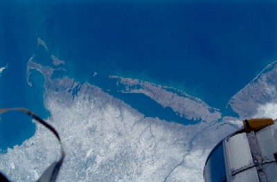
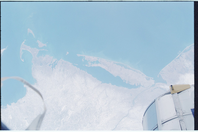
Image Caption: New England Area
The moderating influence of the Atlantic Ocean is visible along the coastline in this synoptic, southeast view of several New England states. The southern limit of the snow covered landscape can be traced from southeast Massachusetts (left center) westward along the northern shore of Long Island Sound and includes the northern end of New Jersey (right center). In addition to Long Island (center), other prominent features on this image includes: Cape Cod; Martha's Vineyard, Nantucket, and Block Islands; and the Hudson River (bottom center). Several southerly draining river systems are discernible in Connecticut and extensive wetlands are observed along New York and New Jersey coastal areas.
The moderating influence of the Atlantic Ocean is visible along the coastline in this synoptic, southeast view of several New England states. The southern limit of the snow covered landscape can be traced from southeast Massachusetts (left center) westward along the northern shore of Long Island Sound and includes the northern end of New Jersey (right center). In addition to Long Island (center), other prominent features on this image includes: Cape Cod; Martha's Vineyard, Nantucket, and Block Islands; and the Hudson River (bottom center). Several southerly draining river systems are discernible in Connecticut and extensive wetlands are observed along New York and New Jersey coastal areas.
