STS102-331-12
| NASA Photo ID | STS102-331-12 |
| Focal Length | mm |
| Date taken | 2001.03.14 |
| Time taken | 17:42:05 GMT |
Cloud masks available for this image:
Spacecraft nadir point: 8.1° N, 59.5° W
Photo center point: 9.0° N, 61.0° W
Photo center point by machine learning:
Photo center point: 9.0° N, 61.0° W
Photo center point by machine learning:
Nadir to Photo Center: Northwest
Spacecraft Altitude: 201 nautical miles (372km)
Country or Geographic Name: | VENEZUELA |
Features: | DELTA, ORINOCO RIVER |
| Features Found Using Machine Learning: | |
Cloud Cover Percentage: | 25 (11-25)% |
Sun Elevation Angle: | 64° |
Sun Azimuth: | 247° |
Camera: | Nikon 35mm film camera |
Focal Length: | mm |
Camera Tilt: | 28 degrees |
Format: | 5755: Portra 160NC, color negative, 35mm, ASA 160 |
Film Exposure: | |
| Additional Information | |
| Width | Height | Annotated | Cropped | Purpose | Links |
|---|---|---|---|---|---|
| 400 pixels | 264 pixels | No | No | Photographic Highlights | Download Image |
| 640 pixels | 426 pixels | No | No | Download Image |
Download Packaged File
Download a Google Earth KML for this Image
View photo footprint information
Download a GeoTIFF for this photo
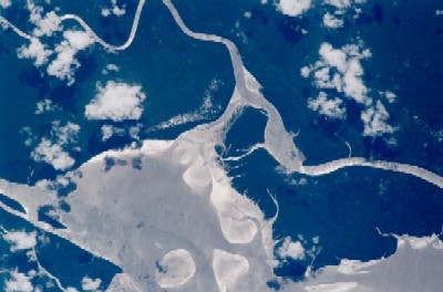
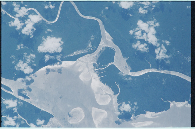
Image Caption: Distributary Channels of the Orinoco River
Several meandering distributary channels of the Orinoco River are seen draining northward into the south side of the Gulf of Paria in eastern Venezuela. These sediment-laden channels carry a tremendous quantity of fluvial material that constantly changes the size and shapes of the shoreline and adjacent islands. An assortment of mud flats and sand bars, seen here as lighter colored features in the water, are affected both by stream flow and tidal forces. Although some sunglint (the sun's reflection off of the water surface) is evident in the image, there may also be some evidence of a sheen on the surface of the water that is caused by the oil drilling operations in the gulf. The extensive dark landscape identifies the flat, swampy coastal plains of northeast Venezuela that is covered by dense stands of vegetation.
Several meandering distributary channels of the Orinoco River are seen draining northward into the south side of the Gulf of Paria in eastern Venezuela. These sediment-laden channels carry a tremendous quantity of fluvial material that constantly changes the size and shapes of the shoreline and adjacent islands. An assortment of mud flats and sand bars, seen here as lighter colored features in the water, are affected both by stream flow and tidal forces. Although some sunglint (the sun's reflection off of the water surface) is evident in the image, there may also be some evidence of a sheen on the surface of the water that is caused by the oil drilling operations in the gulf. The extensive dark landscape identifies the flat, swampy coastal plains of northeast Venezuela that is covered by dense stands of vegetation.
