STS101-721-64

| NASA Photo ID | STS101-721-64 |
| Focal Length | 100mm |
| Date taken | 2000.05.24 |
| Time taken | 07:08:39 GMT |
Resolutions offered for this image:
1035 x 1024 pixels 2071 x 2048 pixels 4143 x 4096 pixels 517 x 512 pixels 2144 x 2140 pixels 400 x 399 pixels
1035 x 1024 pixels 2071 x 2048 pixels 4143 x 4096 pixels 517 x 512 pixels 2144 x 2140 pixels 400 x 399 pixels


Cloud masks available for this image:
Spacecraft nadir point: 40.8° N, 48.1° E
Photo center point: 39.0° N, 49.0° E
Photo center point by machine learning:
Photo center point: 39.0° N, 49.0° E
Photo center point by machine learning:
Nadir to Photo Center: South
Spacecraft Altitude: 187 nautical miles (346km)
Country or Geographic Name: | CASPIAN SEA |
Features: | GRAVITY WAVES, KIROVA B. |
| Features Found Using Machine Learning: | |
Cloud Cover Percentage: | 10 (1-10)% |
Sun Elevation Angle: | 62° |
Sun Azimuth: | 127° |
Camera: | Hasselblad |
Focal Length: | 100mm |
Camera Tilt: | 33 degrees |
Format: | 5069: Kodak Elite 100S, E6 Reversal, Replaces Lumiere, Warmer in tone vs. Lumiere |
Film Exposure: | |
| Additional Information | |
| Width | Height | Annotated | Cropped | Purpose | Links |
|---|---|---|---|---|---|
| 1035 pixels | 1024 pixels | No | No | Download Image | |
| 2071 pixels | 2048 pixels | No | No | Download Image | |
| 4143 pixels | 4096 pixels | No | No | Download Image | |
| 517 pixels | 512 pixels | No | No | Download Image | |
| 2144 pixels | 2140 pixels | No | Photographic Highlights | Download Image | |
| 400 pixels | 399 pixels | No | Photographic Highlights | Download Image |
Download Packaged File
Download a Google Earth KML for this Image
View photo footprint information
Download a GeoTIFF for this photo
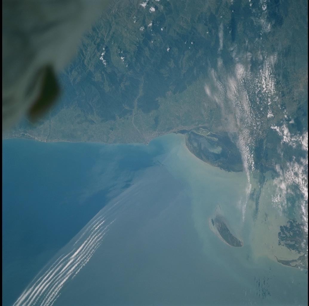
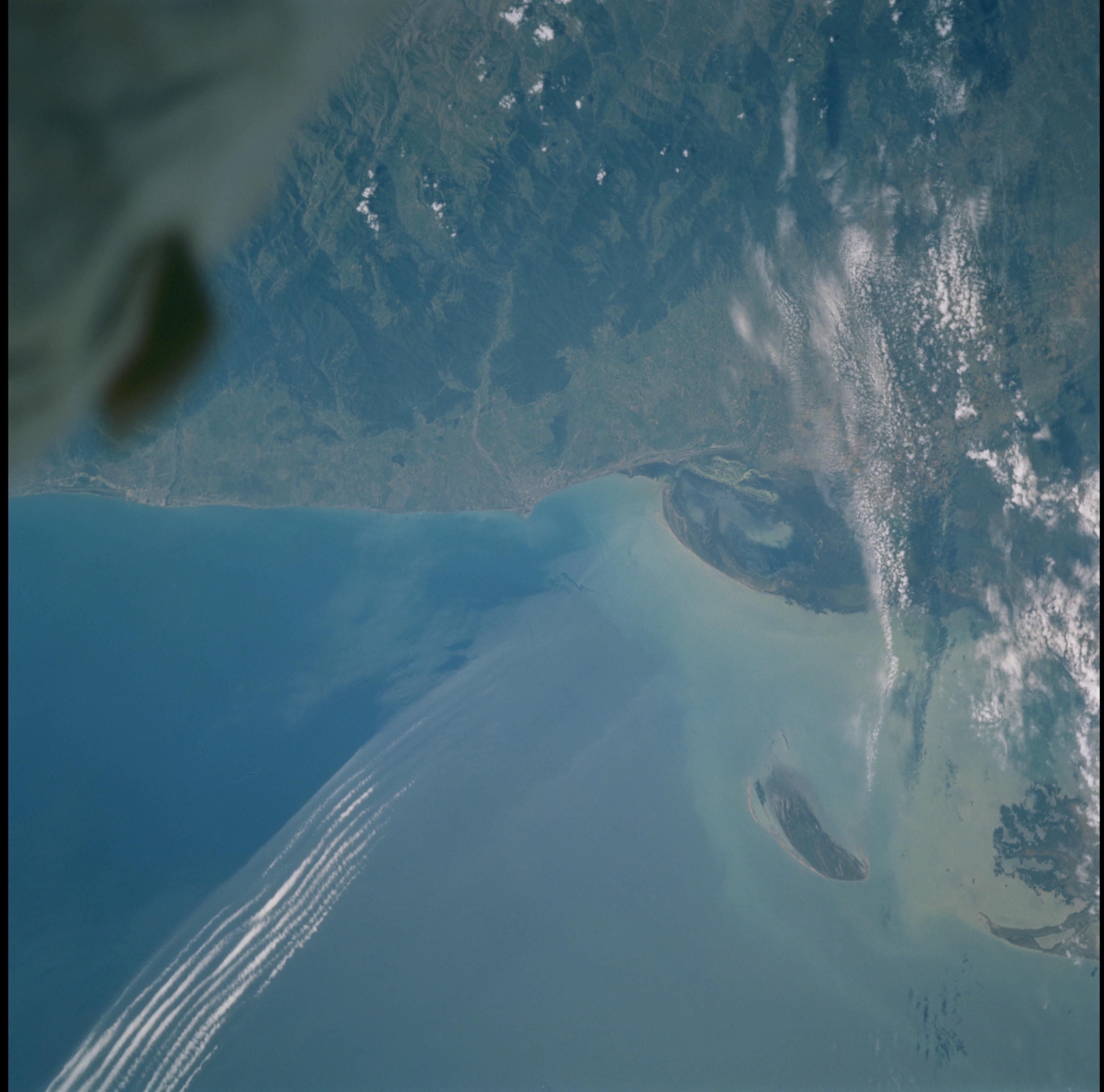
Image Caption: Kura Spit & Frontal Boundary, SW Caspian Sea
The Caspian Sea coast has changed dramatically over time, and in the
past twenty years sea level has risen 2.6 m. The effects of relative
fall and rise are most easily seen where topographic relief is subdued,
as along the coast south of Apsheron Peninsula, Azerbaijan. Comparison
of this photograph of the Kura Spit with STS036-89-51 conveys the magnitude
of change. In 1980 the large island was part of the spit. When STS036 flew in March,
1990 the spit extended ~15 km farther south toward the island. The
STS101 photo reveals further erosion of the central spit, isolation of
the island, and retreat of the shoreline. This area is discussed by E.
I. Ignatov and G. D. Solovieva in one of eleven articles on the Caspian
Sea in Dynamic Earth Environments - Remote Sensing Observations from
Shuttle-Mir Missions, a volume produced by the Office of Earth Sciences
and published by John Wiley & Sons (June, 2000). The light parallel
bands are gravity waves in clouds along an atmospheric frontal boundary.
