STS098-714A-20
| NASA Photo ID | STS098-714A-20 |
| Focal Length | 100mm |
| Date taken | 2001.02.16 |
| Time taken | 22:46:18 GMT |
Resolutions offered for this image:
1031 x 1024 pixels 2063 x 2048 pixels 4127 x 4096 pixels 640 x 640 pixels 515 x 512 pixels 4096 x 4096 pixels
1031 x 1024 pixels 2063 x 2048 pixels 4127 x 4096 pixels 640 x 640 pixels 515 x 512 pixels 4096 x 4096 pixels

Cloud masks available for this image:
Spacecraft nadir point: 32.3° N, 123.3° W
Photo center point: 34.5° N, 119.0° W
Photo center point by machine learning:
Photo center point: 34.5° N, 119.0° W
Photo center point by machine learning:
Nadir to Photo Center: Northeast
Spacecraft Altitude: 202 nautical miles (374km)
Country or Geographic Name: | USA-CALIFORNIA |
Features: | SANTA MONICA MTS., SNOW |
| Features Found Using Machine Learning: | |
Cloud Cover Percentage: | 10 (1-10)% |
Sun Elevation Angle: | 35° |
Sun Azimuth: | 223° |
Camera: | Hasselblad |
Focal Length: | 100mm |
Camera Tilt: | High Oblique |
Format: | 5069: Kodak Elite 100S, E6 Reversal, Replaces Lumiere, Warmer in tone vs. Lumiere |
Film Exposure: | |
| Additional Information | |
| Width | Height | Annotated | Cropped | Purpose | Links |
|---|---|---|---|---|---|
| 1031 pixels | 1024 pixels | No | No | Download Image | |
| 2063 pixels | 2048 pixels | No | No | Download Image | |
| 4127 pixels | 4096 pixels | No | No | Download Image | |
| 640 pixels | 640 pixels | No | No | Photographic Highlights | Download Image |
| 515 pixels | 512 pixels | No | No | Download Image | |
| 4096 pixels | 4096 pixels | No | No | Public Affairs Office (PAO) | Download Image |
Download Packaged File
Download a Google Earth KML for this Image
View photo footprint information
Download a GeoTIFF for this photo
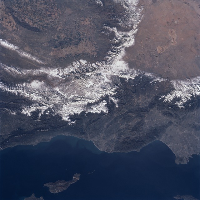
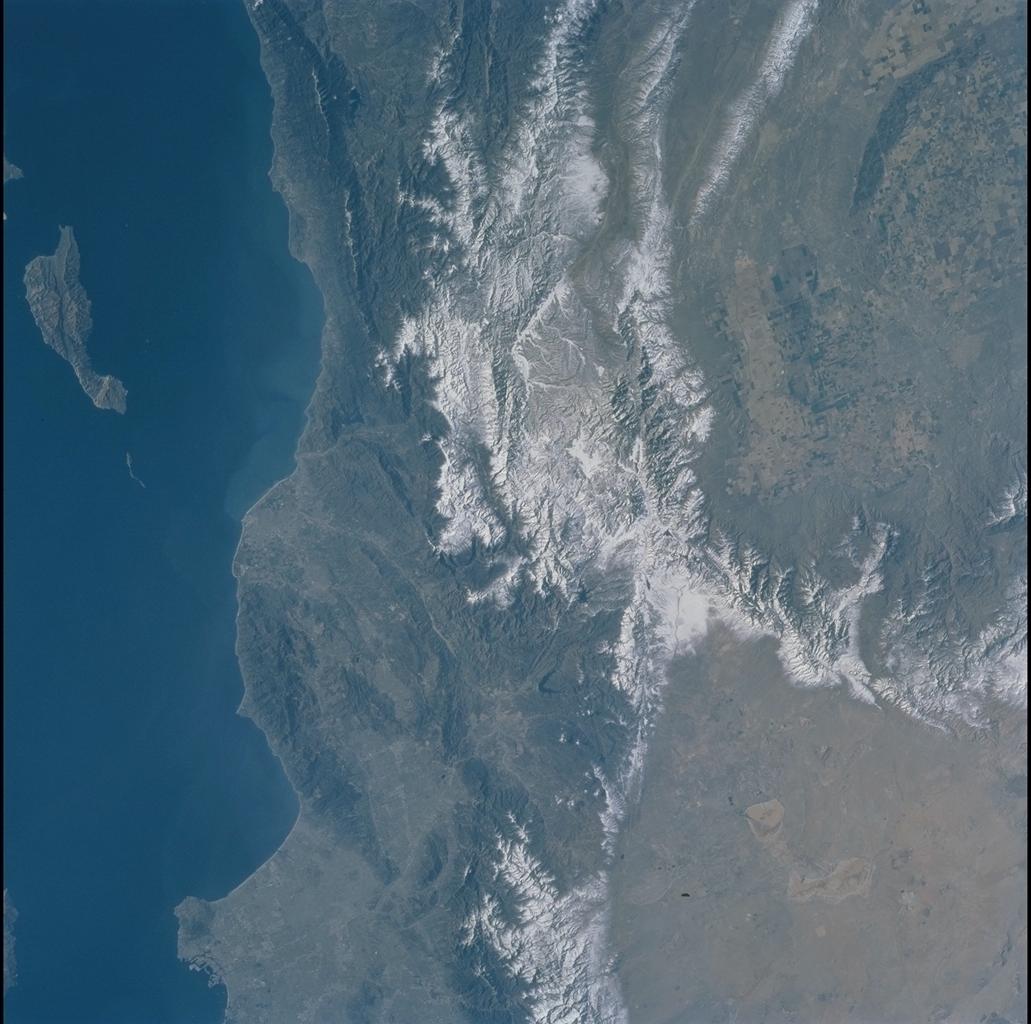
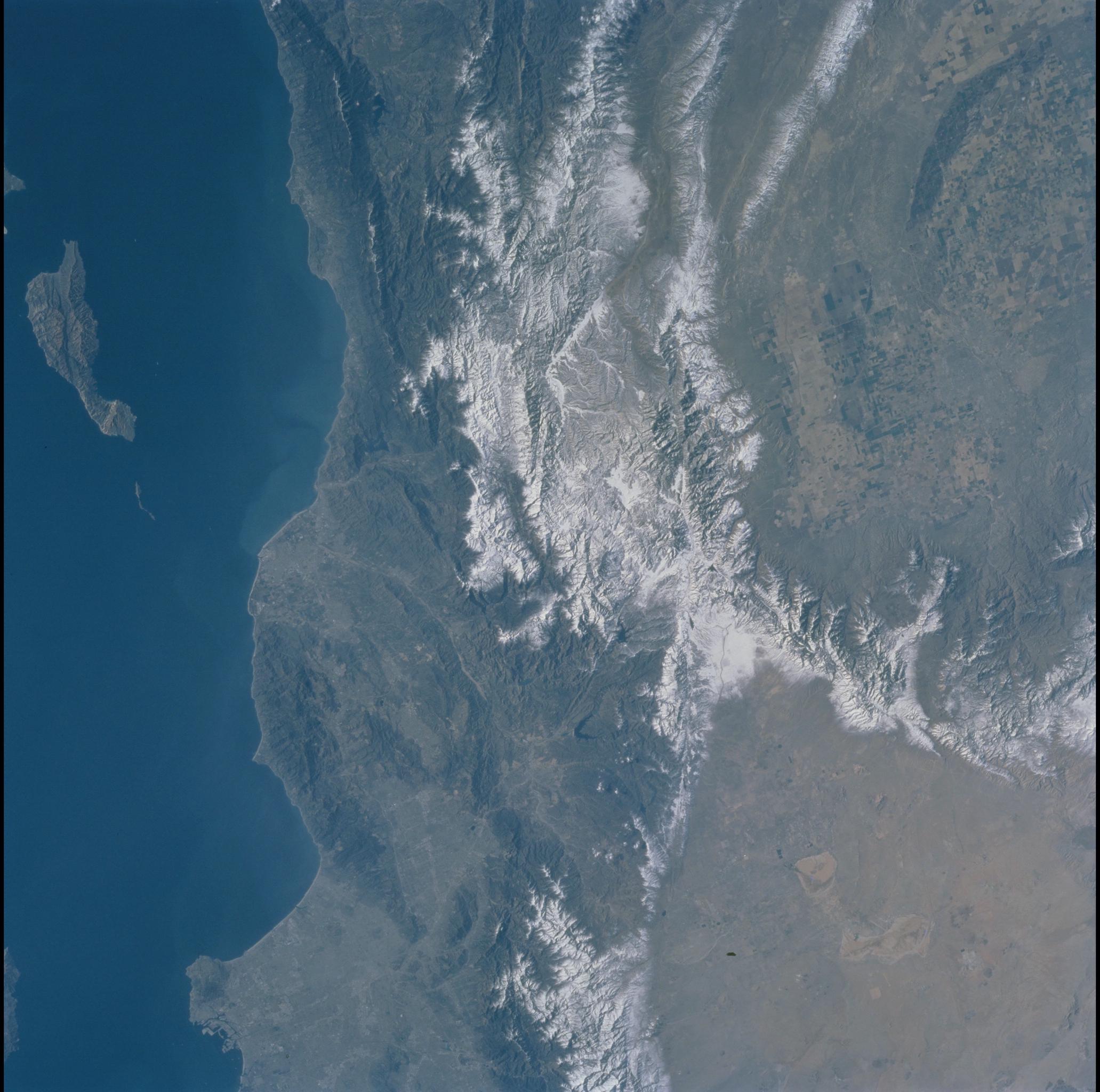
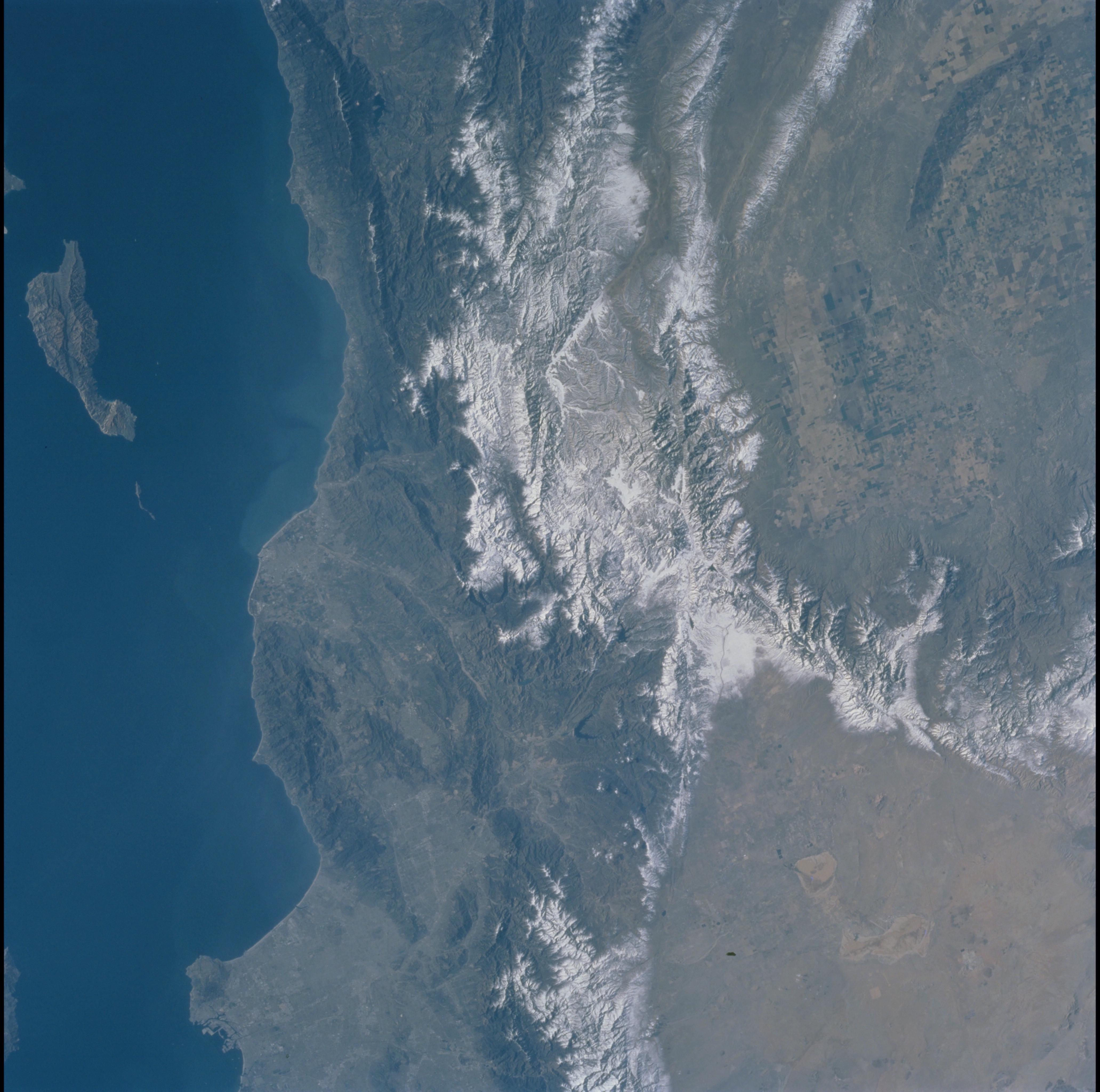
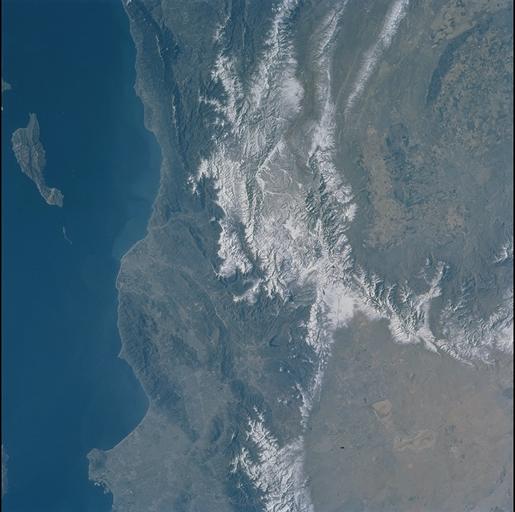
Image Caption: Southern California
Snow blanketing the higher elevations in the Los Padres National Forest (center of the image) and Angeles National Forest (right middle) helps to accentuate and separate three major landform regions in southern California. The northern Los Angeles Basin that includes the San Fernando Valley and the Santa Monica Mountains is visible in the lower right quadrant of the image. The western end of the Mojave Desert (upper right) shows the two distinctive mountain boundaries along the southwest and northwest edge of the desert. The San Andreas Fault and the Garlock Fault converge (snow covered in this scene) at the western end of the desert. The intensively irrigated and cultivated southern end of the San Joaquin Valley that includes Bakersfield is visible (upper left) north of the snow-covered, northeast-southwest trending Tehachapi Mountains. The island off of the California coast (bottom left) is Santa Cruz Island.
Snow blanketing the higher elevations in the Los Padres National Forest (center of the image) and Angeles National Forest (right middle) helps to accentuate and separate three major landform regions in southern California. The northern Los Angeles Basin that includes the San Fernando Valley and the Santa Monica Mountains is visible in the lower right quadrant of the image. The western end of the Mojave Desert (upper right) shows the two distinctive mountain boundaries along the southwest and northwest edge of the desert. The San Andreas Fault and the Garlock Fault converge (snow covered in this scene) at the western end of the desert. The intensively irrigated and cultivated southern end of the San Joaquin Valley that includes Bakersfield is visible (upper left) north of the snow-covered, northeast-southwest trending Tehachapi Mountains. The island off of the California coast (bottom left) is Santa Cruz Island.
