STS097-715-61
| NASA Photo ID | STS097-715-61 |
| Focal Length | 40mm |
| Date taken | 2000.12.10 |
| Time taken | 19:02:23 GMT |
Resolutions offered for this image:
1031 x 1024 pixels 2063 x 2048 pixels 4127 x 4096 pixels 640 x 640 pixels 515 x 512 pixels 4096 x 4096 pixels
1031 x 1024 pixels 2063 x 2048 pixels 4127 x 4096 pixels 640 x 640 pixels 515 x 512 pixels 4096 x 4096 pixels


Cloud masks available for this image:
Spacecraft nadir point: 29.2° S, 68.9° W
Photo center point: 29.5° S, 68.5° W
Photo center point by machine learning:
Photo center point: 29.5° S, 68.5° W
Photo center point by machine learning:
Nadir to Photo Center: Southeast
Spacecraft Altitude: 192 nautical miles (356km)
Country or Geographic Name: | ARGENTINA |
Features: | ANDES MOUNTAINS |
| Features Found Using Machine Learning: | |
Cloud Cover Percentage: | 25 (11-25)% |
Sun Elevation Angle: | 55° |
Sun Azimuth: | 271° |
Camera: | Hasselblad |
Focal Length: | 40mm |
Camera Tilt: | 9 degrees |
Format: | 5069: Kodak Elite 100S, E6 Reversal, Replaces Lumiere, Warmer in tone vs. Lumiere |
Film Exposure: | |
| Additional Information | |
| Width | Height | Annotated | Cropped | Purpose | Links |
|---|---|---|---|---|---|
| 1031 pixels | 1024 pixels | No | No | Download Image | |
| 2063 pixels | 2048 pixels | No | No | Download Image | |
| 4127 pixels | 4096 pixels | No | No | Download Image | |
| 640 pixels | 640 pixels | No | No | Photographic Highlights | Download Image |
| 515 pixels | 512 pixels | No | No | Download Image | |
| 4096 pixels | 4096 pixels | No | No | Public Affairs Office (PAO) | Download Image |
Download Packaged File
Download a Google Earth KML for this Image
View photo footprint information
Download a GeoTIFF for this photo
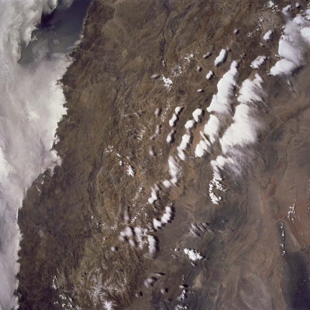
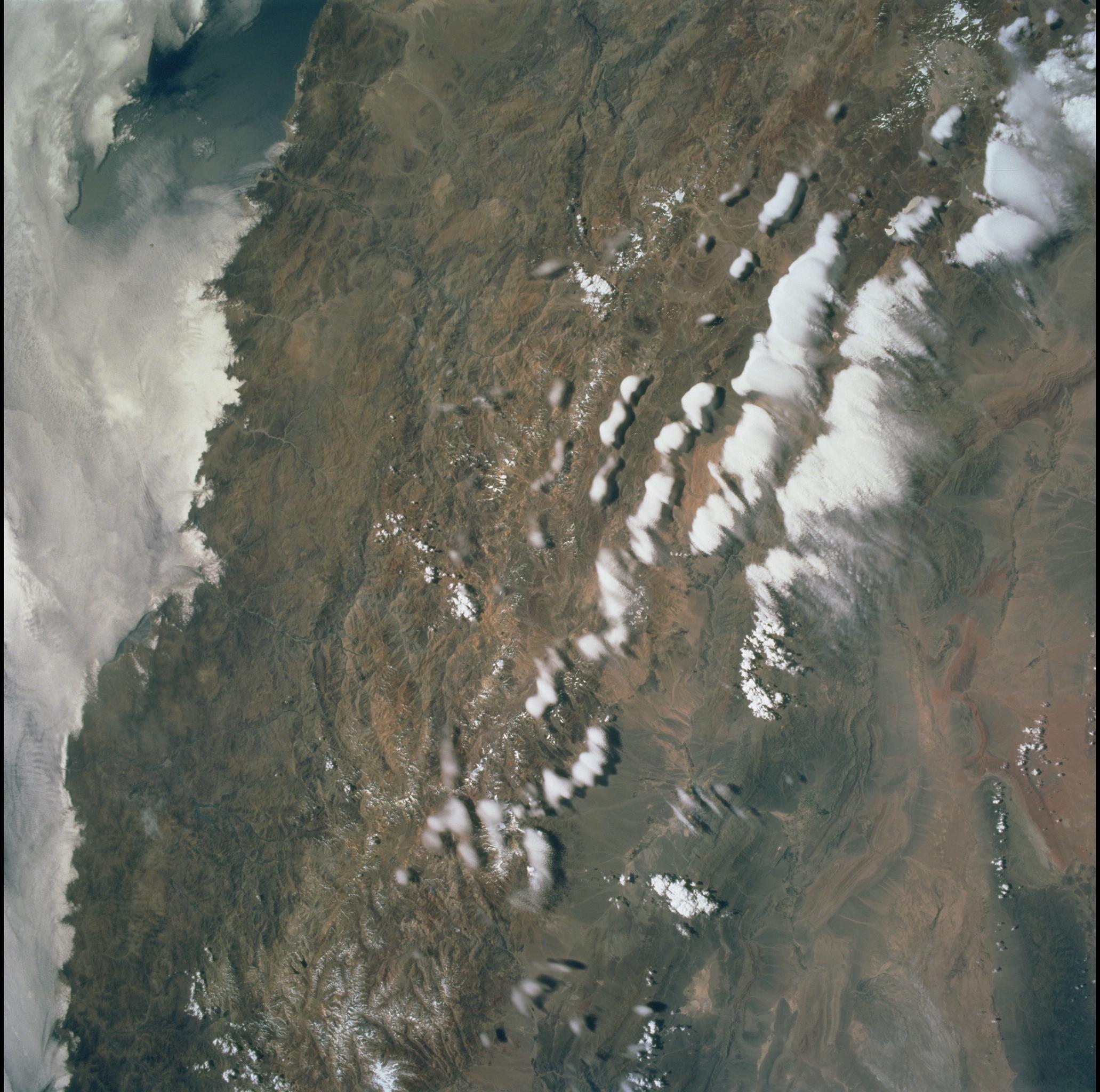
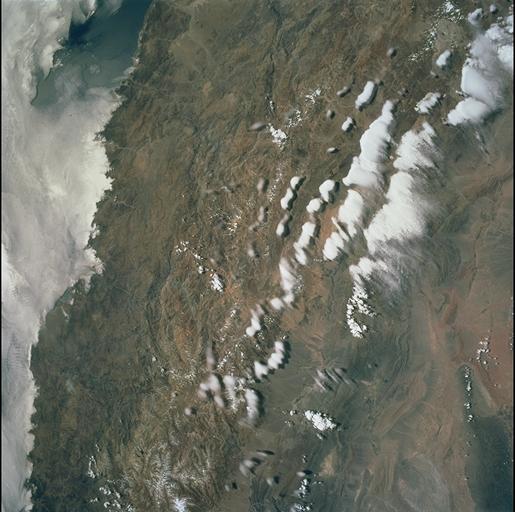
Image Caption: Central Andes Mountains, Argentina/Chile December 10, 2000
Extending 5500 miles (8850 km) along the western coast of South America from northern Colombia to Cape Horn in southern Chile, the Andes are the longest mountain range, above sea level, and the second highest range in the world. This immense system came into existence nearly 70 million years ago. With numerous active volcanoes and a slow uplift, the building of the Andes Mountains continues today rising 4 inches (10 cm) per century. In this north-looking view, snow covers the higher peaks of the range, some of which rise to over 20000 feet (6100 meters) above sea level. Along the left or western portion of the view, clouds can be seen along coastal areas of Chile. In the bottom left quadrant of the scene, the blue waters of the Paloma Reservoir, a recreational lake, are visible. The folded Tontal Range (bottom center) and the Valle Fertil Range (upper right quadrant and partially cloud covered) of western Argentina can be seen. The rocks of these ranges are ancient compared to the younger volcanic peaks and ranges of the Andes. The city of San Juan, Argentina is visible on the eastern (right) base of the Tontal Range in the lower right quadrant of the view.
Extending 5500 miles (8850 km) along the western coast of South America from northern Colombia to Cape Horn in southern Chile, the Andes are the longest mountain range, above sea level, and the second highest range in the world. This immense system came into existence nearly 70 million years ago. With numerous active volcanoes and a slow uplift, the building of the Andes Mountains continues today rising 4 inches (10 cm) per century. In this north-looking view, snow covers the higher peaks of the range, some of which rise to over 20000 feet (6100 meters) above sea level. Along the left or western portion of the view, clouds can be seen along coastal areas of Chile. In the bottom left quadrant of the scene, the blue waters of the Paloma Reservoir, a recreational lake, are visible. The folded Tontal Range (bottom center) and the Valle Fertil Range (upper right quadrant and partially cloud covered) of western Argentina can be seen. The rocks of these ranges are ancient compared to the younger volcanic peaks and ranges of the Andes. The city of San Juan, Argentina is visible on the eastern (right) base of the Tontal Range in the lower right quadrant of the view.
