STS096-715-14
| NASA Photo ID | STS096-715-14 |
| Focal Length | 40mm |
| Date taken | 1999.06.04 |
| Time taken | 00:18:58 GMT |
Resolutions offered for this image:
1034 x 1024 pixels 2069 x 2048 pixels 4139 x 4096 pixels 517 x 512 pixels
1034 x 1024 pixels 2069 x 2048 pixels 4139 x 4096 pixels 517 x 512 pixels


Cloud masks available for this image:
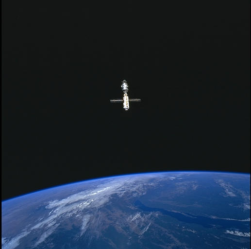
Spacecraft nadir point: 50.1° N, 116.8° E
Photo center point: 50.0° N, 105.0° E
Photo center point by machine learning:
Photo center point: 50.0° N, 105.0° E
Photo center point by machine learning:
Nadir to Photo Center: West
Spacecraft Altitude: 212 nautical miles (393km)
Country or Geographic Name: | MONGOLIA |
Features: | PAN-EARTH LIMB, ISS |
| Features Found Using Machine Learning: | |
Cloud Cover Percentage: | 15 (11-25)% |
Sun Elevation Angle: | 37° |
Sun Azimuth: | 99° |
Camera: | Hasselblad |
Focal Length: | 40mm |
Camera Tilt: | High Oblique |
Format: | 5069: Kodak Elite 100S, E6 Reversal, Replaces Lumiere, Warmer in tone vs. Lumiere |
Film Exposure: | Normal |
| Additional Information | |
| Width | Height | Annotated | Cropped | Purpose | Links |
|---|---|---|---|---|---|
| 1034 pixels | 1024 pixels | No | No | Download Image | |
| 2069 pixels | 2048 pixels | No | No | Download Image | |
| 4139 pixels | 4096 pixels | No | No | Download Image | |
| 517 pixels | 512 pixels | No | No | Download Image |
Download Packaged File
Download a Google Earth KML for this Image
View photo footprint information
Download a GeoTIFF for this photo
Image Caption: Lake Baykal, the largest freshwater lake in the world (30,500 sq km in
area; 1741 m deep), stretches beneath the International Space Station
in this westward view. At the southwest end of the lake, the
university city of Irkutsk occupies the end of a narrow bay on the
northern coast. Academician Ridge extends northeastward into the
lake.
The lake fills most of the Baykal rift which, like the Rio
Grande rift of southwestern North America, began opening about 28
million years ago; some segments are still active. Hot springs rise
and enter the lake along the faults that bound Academician Ridge, and
million-year-old volcanic vents (Tunka, Khamar Daban) have constructed
the highlands at the southwest end of the rift.
