STS094-753-55
| NASA Photo ID | STS094-753-55 |
| Focal Length | 250mm |
| Date taken | 1997.07.12 |
| Time taken | 13:10:38 GMT |
Resolutions offered for this image:
4072 x 4072 pixels 639 x 639 pixels 505 x 510 pixels 479 x 479 pixels
4072 x 4072 pixels 639 x 639 pixels 505 x 510 pixels 479 x 479 pixels


Cloud masks available for this image:
Spacecraft nadir point: 27.5° N, 80.4° W
Photo center point: 25.5° N, 80.0° W
Photo center point by machine learning:
Photo center point: 25.5° N, 80.0° W
Photo center point by machine learning:
Nadir to Photo Center: South
Spacecraft Altitude: 157 nautical miles (291km)
Country or Geographic Name: | USA-FLORIDA |
Features: | MIAMI |
| Features Found Using Machine Learning: | |
Cloud Cover Percentage: | 5 (1-10)% |
Sun Elevation Angle: | 32° |
Sun Azimuth: | 80° |
Camera: | Hasselblad |
Focal Length: | 250mm |
Camera Tilt: | 38 degrees |
Format: | 5069: Kodak Elite 100S, E6 Reversal, Replaces Lumiere, Warmer in tone vs. Lumiere |
Film Exposure: | Normal |
| Additional Information | |
| Width | Height | Annotated | Cropped | Purpose | Links |
|---|---|---|---|---|---|
| 4072 pixels | 4072 pixels | No | No | Earth From Space collection | Download Image |
| 639 pixels | 639 pixels | No | No | Earth From Space collection | Download Image |
| 505 pixels | 510 pixels | No | No | Download Image | |
| 479 pixels | 479 pixels | Download Image |
Download Packaged File
Download a Google Earth KML for this Image
View photo footprint information
Download a GeoTIFF for this photo
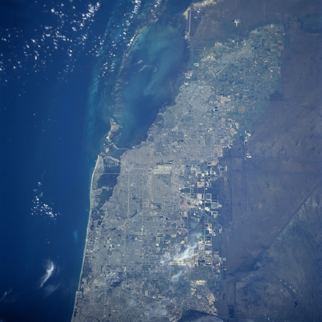
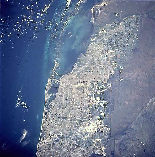
Image Caption: STS094-753-055 Miami, Florida July 1997
The Greater Miami area can be seen in this spectacular south-looking view. Near the center of the image, the runways of Miami International Airport are discernible. East of the airport across Biscayne Bay, the city of Miami Beach is visible. Directly south of Miami Beach is the island of Key Biscayne. The far eastern portions of the Everglades are discernible to the west of Miami. The Miami area is one of the most popular and famous resort regions in the United States. Near the upper right portion of the image, the city of Homestead can be seen. In 1992 Hurricane Andrew, a category 4 hurricane, destroyed most homes and other structures while passing directly over Homestead. Hurricane Andrew is one of the most destructive hurricanes ever to make landfall in the United States.
The Greater Miami area can be seen in this spectacular south-looking view. Near the center of the image, the runways of Miami International Airport are discernible. East of the airport across Biscayne Bay, the city of Miami Beach is visible. Directly south of Miami Beach is the island of Key Biscayne. The far eastern portions of the Everglades are discernible to the west of Miami. The Miami area is one of the most popular and famous resort regions in the United States. Near the upper right portion of the image, the city of Homestead can be seen. In 1992 Hurricane Andrew, a category 4 hurricane, destroyed most homes and other structures while passing directly over Homestead. Hurricane Andrew is one of the most destructive hurricanes ever to make landfall in the United States.
