STS094-750-37
| NASA Photo ID | STS094-750-37 |
| Focal Length | 250mm |
| Date taken | 1997.07.15 |
| Time taken | 18:00:56 GMT |
Resolutions offered for this image:
4000 x 4000 pixels 639 x 639 pixels 506 x 504 pixels 479 x 479 pixels
4000 x 4000 pixels 639 x 639 pixels 506 x 504 pixels 479 x 479 pixels

Cloud masks available for this image:
Spacecraft nadir point: 23.1° N, 159.1° W
Photo center point: 22.0° N, 159.5° W
Photo center point by machine learning:
Photo center point: 22.0° N, 159.5° W
Photo center point by machine learning:
Nadir to Photo Center: South
Spacecraft Altitude: 157 nautical miles (291km)
Country or Geographic Name: | USA-HAWAII |
Features: | KAUAI |
| Features Found Using Machine Learning: | |
Cloud Cover Percentage: | 20 (11-25)% |
Sun Elevation Angle: | 26° |
Sun Azimuth: | 76° |
Camera: | Hasselblad |
Focal Length: | 250mm |
Camera Tilt: | 24 degrees |
Format: | 5069: Kodak Elite 100S, E6 Reversal, Replaces Lumiere, Warmer in tone vs. Lumiere |
Film Exposure: | Under Exposed |
| Additional Information | |
| Width | Height | Annotated | Cropped | Purpose | Links |
|---|---|---|---|---|---|
| 4000 pixels | 4000 pixels | No | No | Earth From Space collection | Download Image |
| 639 pixels | 639 pixels | No | No | Earth From Space collection | Download Image |
| 506 pixels | 504 pixels | No | No | Download Image | |
| 479 pixels | 479 pixels | Download Image |
Download Packaged File
Download a Google Earth KML for this Image
View photo footprint information
Download a GeoTIFF for this photo
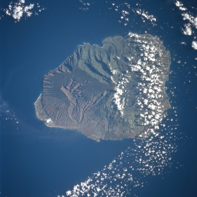
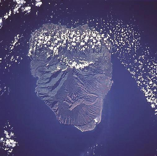
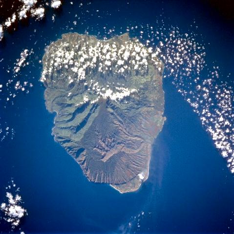
Image Caption: STS094-750-037 Kauai, Hawaiian Islands July 1997
The oldest of the Hawaiian chain of islands, the Garden Island of Kauai covers an area of 549 sq. miles (1422 sq. km) and was formed by now-extinct volcanoes. High annual rainfall has eroded deep valleys in the central mountain mass. Kauai has several short streams, being the only island of the Hawaiian group that may be said to have rivers. Waimea Canyon, 10 miles (16 km) long and over 3000 feet (915 meters) deep is the westernmost of the several deep valleys cut into the surface of the island (prominent S-shaped valley across the thinner end of the island) and has been called the 'Grand Canyon of the Pacific'. The famous Pali Coast is visible near the bottom left of the island. Besides tourism, Kauai's other major industry is sugarcane.
The oldest of the Hawaiian chain of islands, the Garden Island of Kauai covers an area of 549 sq. miles (1422 sq. km) and was formed by now-extinct volcanoes. High annual rainfall has eroded deep valleys in the central mountain mass. Kauai has several short streams, being the only island of the Hawaiian group that may be said to have rivers. Waimea Canyon, 10 miles (16 km) long and over 3000 feet (915 meters) deep is the westernmost of the several deep valleys cut into the surface of the island (prominent S-shaped valley across the thinner end of the island) and has been called the 'Grand Canyon of the Pacific'. The famous Pali Coast is visible near the bottom left of the island. Besides tourism, Kauai's other major industry is sugarcane.
